An interesting turn of events has occured this past two months concerning the I-49 Lafayette Connector freeway studies.
The Lafayette Independent recently obtained via the Freedom of Information Act inquiry a copy of a new Supplemental Agreement that was signed by both the Louisiana Department of Transportation and Development and the lead consultant agency Stantec for the project. This new agreement extends the existing contract for engineering and environmental study and the Conceptual Design and Context Sensitive Solutions (CSS) processes from its current termination of June 2017 to October 2019.
A copy of the Supplemental Agreement and its associated appendices is below (via Scribd.com):
The 28 month extension is essentially to allow for a full process of initializing, developing, and completing a Supplemental Environmental Impact Statement (SEIS), which the Federal Highway Administration (FHWA) had deemed to be necessary due to the substantial changes in the environment in Lafayette surrounding the project, as well as the design modifications sought by local Lafayette stakeholders and the public.
According to the terms of the Supplemental Agreement, LADOTD, FHWA, the Connector consulting crew (organized under the label Lafayette Connector Partners (LCP)), and the Lafayette City-Parish Consolidated Government (LCG), will coordinate and organize new studies, analysis, and public interaction using the same 3-tier evaluation approach as used under the current Concept Refinement Process (CRP). That process was launched in January of 2016 due to the desire of stakeholders in Lafayette to modify the design of the alternative approved in the original 2003 Final EIS/Record of Decision in order to mitigate the footprint along the neighborhoods directly affected.
Originally, the CRP had produced an initial group of 19 Conceptual Design Alternatives (CDAs) utilizing 6 design concepts for the central section of the Connector freeway between Pinhook Road and the Louisiana & Delta Railroad spur rail line; complemented by 25 spot Potential Design Modifications (PDMs) along the entire length of the corridor from just south of Lafayette Regional Airport to just south of the I-49/I-10 interchange. This was analyzed under the Tier I evaluations, and reduced to 4 concept alternatives (2 “Series 4” elevated; 2 “Series 6” partially depressed), which along with the PDMs were further vetted through the Tier II analysis.
Under the newly refined process under this extended agreement, the remaining Tier II analysis would be finalized and six “hybrid” or “End-to-End” alternatives would be produced to advance into the Tier III more detailed environmental evaluation and to begin the SEIS process. This would result in two finalist Supplemental Alternatives which would undergo the full SEIS process vetting for environmental impacts. The original approved 2003 ROD alternative would also be included, but only as a control for comparison purposes.
A Supplemental Preferred Alternative would then be produced which would be sent first to LCG (via the City-Parish Council) and the Acadiana Metropolitan Planning Organization (Acadiana MPO) for review and ratification, and then presented in the Draft SEIS for review by the FHWA, relevant federal, state, and local agencies, and ultimately public comment via an official Public Hearing. Based on the feedback, a Final SEIS presenting the Selected Supplemental Alternative would be produced and reviewed, leading to a Supplemental ROD stating final approval. Then the original CSS/Conceptual Study scope would kick back in for detailed design features and developing the Complete Functional Plan for elements within and surrounding the corridor.
There are some very interesting aspects to be found in this modified process, and the agreement does reveal some new information not made public before.
The recent induction of the Freetown-Port Rico neighborhood as a Historical District has forced some minor alteration of design for a segment of the freeway near Pinhook Road, where the southbound Evangeline Thruway roadway serves as the boundary for the newly formed district. Some homes facing the southbound Thruway from Fifteenth to Pinhook along the FTPRHD would possibly be adversely impacted by the proximity of the elevated structure or control of access requirements, which would prompt a flag under Section 4(f) protocols.
Another more major conflict occurs at the proposed interchange with University Avenue and Surrey Street near the Lafayette Regional Airport (LFT). The original interchange design for the 2003 ROD approved alternative was based on a 350 foot displacement of a runway at LFT in order for the glide path approach to successfully clear the vertical height for the elevated overpass over University/Surrey. However, in 2016, the Federal Aviation Administration imposed new rules for airports requiring additional runway extension space for incorporating EMAS (Engineered Materials Arrest Systems) to prevent runway overruns. This added an additional 300 feet to the proposed 350 foot extension, which would cause a much more serious impact to wetland areas and Bayou Tortue. Therefore, new alternatives for the University interchange that would not require the runway displacement had to be developed, creating new issues and opportunities. A new proposal that would realign the University/Surrey interchange slightly northward to avoid impacting the glide path introduces 4(f) takings of Beaver Park near Beaver Lake, and could potentially flag 6(f) takings of a boat access ramp serving Beaver Lake. A University/Surrey overpass of a partially depressed I-49 mainline is also under consideration.
A third conflict that has developed involves the Kaliste Saloom Road interchange just south of the airport; a hotel was built on Hugh Wallis Road near the Walls Estate property that would affect the geometry of the on-ramp from the Connector southbound to Kaliste Saloom Road, as well as a local connector road that would replace the at-grade connection betweet Kaliste Saloom and Hugh Wallis. Adjustments to the ramps would have to be made; and possibly even alterations to the design of the directional interchange.
The most significant issue to date, however, is the Connector’s crossing of the site that was formerly the old classification and maintenance yard for Southern Pacific Railroad. That site has been the target of litigation for allegedly being a hazardous waste producer that has contaminated both the soil and potentially the drinking water supply through the Chicot Aquifer, which runs nearly 40 to 60 feet under the city. Environmental Assessments have been done for the rail yard site, and further evaluation for remediation and cleanup will be done as part of the SEIS; nevertheless, it has become the main flash point for those who oppose the project in its entirity. On the other side of the debate, the Evangeline Corridor Initiative (ECI) has also targeted the site for future development upon cleanup as a means of reconnecting the Freetown-Port Rico and McComb-Veazey neighborhoods, through additional cross streets underneath the Connector freeway. That would also require shifting the south connection ramps linking the Connector mainline to the Thruway, currently proposed at Eleventh Street, to be shifted further southward or eliminated altogether.
The original issue of how the Connector would impact the adjacent Sterling Grove Historical District as it crosses just near downtown is still very much involved. The most recent proposals would shift the northbound Evangeline Thruway roadway further west away from the perimeter of Sterling Grove and St. Genevieve Catholic Church/School, but would also sever Mudd Avenue east of the Thruway and Simcoe Street by diverting its traffic onto the Second/Third Streets couplet and Chestnut Street. (The latter would allow for connection slip ramps to be built to link the Connector mainline to the Thruway frontage system at Second Street.) The ECI and locals would prefer to keep Simcoe and Mudd open and continuous, and shift the north connection ramps to just north of Mudd Avenue.
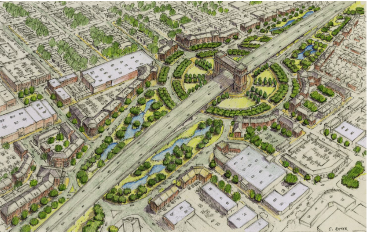
Finally, there is the north section from the L&DRR to I-10, where the ECI has developed an ambitious and striking plan to convert the corridor into a “gateway” for travelers coming into Lafayette. The original plan under the 2003 ROD was for the Thruway to evolve into a parallel frontage road system, with slip ramps connecting the mainline with the frontage roads making up the Willow Street interchange for local access. The ECI’s proposal, however, would replace that with a large traffic circle interchange, where Willow Street, the frontage roads, and the freeway ramps would integrate with each other using the super “roundabout”. (The image at the top of the home page of this blog illustrates the ECI’s “North Gateway” proposal.) Smaller circles tying into the Willow Circle would be developed at the intersection where the frontage roads meet Martin Luther King Drive/Castille Avenue and the intersection of the frontage roads with Donlon Avenue/the access road to the Lafayette Northside Walmart Supercenter store (“Walmart Drive”). For its worth, the LADOTD has proposed its own counter design for the Willow interchange, based on their “dogbone roundabout” design. Analysis and a final decision on design will be part of the SEIS/CFP process.
Other processes that would have to be resolved and finalized under the new SEIS process are as follows: Updating the Section 106 Historical Resources analysis and issuing a revised Memorandum of Agreement for mitigation plans for Sterling Grove and Freetown-Port Rico; revised and updated geometry to reflect increases in traffic counts; updated traffic modeling to compute traffic data for existing conditions, 2040 design year conditions both with and without the Connector built, and determining the scope of traffic modeling for the Thruway section downtown whether it remains a coupled or is converted into a “grand boulevard”; and adding additional public feedback, including two new SEIS Public Meetings and the official Draft SEIS Public Hearing.
The original three committee CSS approach (Community Work Group, Technical Advisory, and Executive) for vetting and approving elements of the process would continue under this new agreement.
All in all, everything has been basically pushed forward to hopefully streamline and improve the process. Let’s see what happens.