Well..after three months of what seemed to be inaction, the I-49 Connector Concept Refinement Process/Supplemental Environmental Impact Statement/CSS Design processes seem to be back in action now.
On Wednesday and Thursday, two of the Connector CSS Committees – Community Work Group on Wednesday and Technical Advisory Committee on Thursday – had their first meetings in three months to get an update from the Lafayette Connector Partners consultant team on progress with the project. In case you have missed it, the LCP team recently got their contract extended for another 2-1/2 years in order to complete the Supplemental EIS and produce a new revised alternative to the freeway design approved in 2003.
The main points that came across from the meetings can be summarized below.
First, some major design tweaking was finalized on the southern section near Lafayette Regional Airport, in response to some major issues that had to be resolved.
The original concept passed by the 2003 ROD assumed that one of the LFT runways (Runway 11-29) would have to be displaced by 350 feet to allow for a regulation design for the University Avenue/Surrey Street overpass of the Connector mainline to avoid violating that runway’s flight path. In October of last year, however, the Federal Aviation Administration (FAA) imposed new rules requiring airports to install Emergency Materials Arrestor Systems (EMAS) runway extensions to prevent overruns of aircraft; this would have potentially added an additional 300 feet of runway extension to the already planned 350 feet displacement that would have been required for the Connector freeway.
Given that such an addition would have required taking far more wetlands than would have been proposed, the FHWA and the LCP was forced to reassess the design for the University/Surrey interchange and develop alternatives that would not require the runway displacement. This is required because Section 404 regulations are pretty tough on displacing wetlands.
The alternatives discussed included:
— Lowering the profile of the Connector freeway overpass over University/Surrey so that the existing flight path (without the 350′ runway displacement) would be retained. This would be accompanied by lowering the grade of University/Surrey to allow standard vertical clearance below the underpass.
— Shifting the design of the University/Surrey interchange so that University/Surrey would pass over the Connector freeway on a partially elevated structure, while the Connector mainline would be partially depressed to cross underneath University/Surrey.
— Shifting the alignment of University/Surrey sightly to the north to move the interchange further away from the glide path of Runway 11-29. This would, however, come with some major issues of taking land from Beaver Park, which is a Section 4(f) property, and potentially taking access from a boat launching facility for Beaver Lake, which would be a potential Section 6(f) violation. Both 4(f) and 6(f) regulations require that alternatives be taken to prevent taking of protected resources.
Ultimately, it was decided that the best and most cost efficient course was Option #1: reduce the profile of the Connector overpass and lower University/Surrey. This effectively removes the risk to Runway 11-29’s glide path and allows for the EMAS extensions to be implemented.
Another significant change was the revision of the design for the proposed Kaliste Saloom Road interchange. The original design approved by the 2003 ROD called for a 3-way fully directional interchange with flyover ramps over the Connector mainline and BNSF/UP railroad mainline. The highest ramp (from northbound Kaliste Saloom to the northbound frontage road and northbound Connector mainline) would be up to 40 feet high. Here’s an illustration graphic of the original proposal (from the presentation given at the latest meetings, via the Lafayette Connector website):

Also notice how the original design had the southbound frontage road wrap around the back of the Acadiana Dodge car dealership, and how the original ramps and access road connecting Kaliste Saloom Road and Hugh Wallis Road conflict with a hotel establishment that was recently built.
In its place, the LCP design team created an interesting alternative design which reduced both the ROW required and the height of the interchange. The flyover ramps are replaced by a single structure where the left turning movements (from east bound Kaliste Saloom Road to northbound Evangeline Thruway/I-49 and from northbound I-49 frontage road to westbound Kaliste Saloom) meet and cross each other at grade, similar to a Single Point interchange. In addition, the connecting access road between Kaliste Saloom and Hugh Wallis is shifted south to parallel the new Kaliste Saloom overpass structure, and split into two roadways which connect to Kaliste Saloom Rd. via RIRO (Right-In-Right-Out) connections just east of the Episcopal School of Acadiana entrance.

The new design also shifts the southbound frontage road to flank the Connector mainline, passing in front of Acadiana Dodge rather than behind it. There was some concern that such a design would require taking the showroom of the dealership, but apparently that has been resolved.
In addition to these changes, the LCP team also addressed which Potential Design Modifications (PDMs) would advance into the Tier III process. The page below lists all the PDMs considered. The ones highlighted in black are the ones that advanced into Tier III and will be incorporated into the End-to-End Alternatives to be studied in the SEIS; the red highlighted ones are those that were totally rejected; and the blue highlighted ones were to be further negotiated and discussed.

The most striking aspect about this list is that the blue highlighted PDMs that remain to be resolved all have to do with enhancements desired by Lafayette Consolidated Government to mitigate the impact of the Connector through the central core of Lafayette, but which by law the Federal and state government couldn’t fund directly as part of the project. This means that if LCG wants to have a signature bridge or pedestrian walkways or a higher clearance for the elevated structures, they would have to find the revenue to pay for it. That may be a significant sticking point, considering the paucity of funding and the general attitude against taxation.
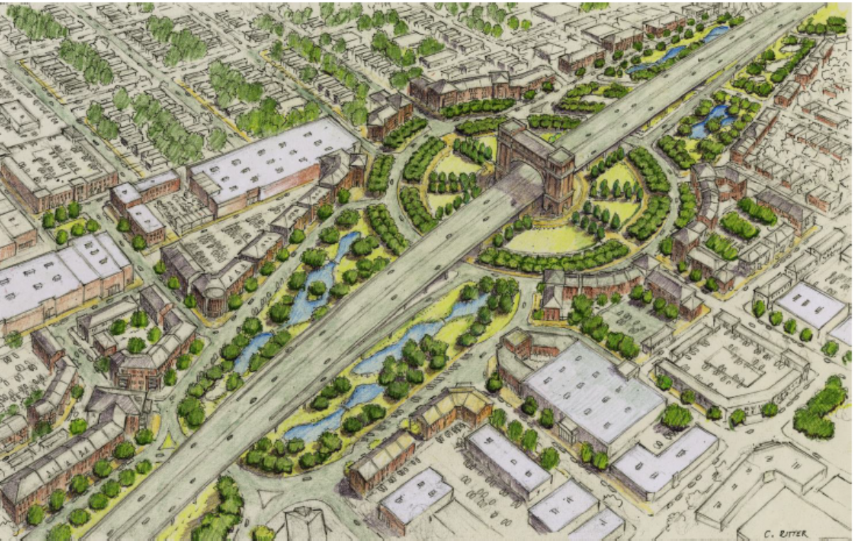
Another real sticking point comes around the rejection of PDM #23-7, a proposed “dogbone roundabout” design for the Willow Street interchange. The Evangeline Corridor Initiative, a project of the Evangeline Thruway Redevelopment Team that was paid for by a Federal TIGER Grant, had proposed a different interchange design for Willow: a large rotary circle interchange in which an arch-like structure would straddle the elevated mainline to serve as a gateway for North Lafayette.

The LCP design team, though, had blown off the ECI’s proposal in favor of studying the “dogbone roundabout” design, which they have developed and implemented in other areas. Their traffic studies found that such a design would not work for Willow Street due to heavy turning volumes between Willow Street and the Evangeline Thruway/Connector, and pretty much recommended the original “slip ramp” diamond interchange design approved by the 2003 ROD.
Obviously, representatives of the ECI were not too happy, as seen in this snippage of coverage of the meetings from the Lafayette Advertiser:
Kevin Blanchard, who sits on the Evangeline Thruway Redevelopment Team working for the city to improve the Evangeline Thruway area in conjunction with the I-49 project, was surprised to learn the ETRT’s plan for a rotary circle with signature feature at Willow Street has been scrapped by the I-49 planners.
The I-49 Connector will be elevated as it crosses Willow Street, a gateway into the city. Blanchard said the ETRT team proposed a large rotary circle with a gateway feature such as an arch that would add value to the urban space.
Blanchard asked for a comparison of traffic volumes expected in a roundabout versus a rotary circle.
“We’re talked in this process about partnering with locals,” he said. “Let’s look at what was proposed locally, which was not a roundabout. It is one of the priorities of the ETRT.”
This isn’t the first time that the ETRT has clashed directly with the Connector planners; it took the ECI to force the LCP and LADOTD to even consider the Partially Depressed/Cut and Cover options for Tier II, only to have it removed from further consideration with great consternation in Feburary.
The next steps for the LCP will be to finalize and introduce to the public the End-to-End Alternatives, that will then be refined and reduced to two finalist Supplemental Alternatives, which will then be fully vetted through the Supplemental EIS process. The original 2003 EIS/ROD Selected Alternative will also be included, but only as a control for comparison to the others. It’s assumed that a Supplemental Preferred Alternative would be presented prior to the release of the Draft SEIS, probably by spring of next year, with a Final SEIS/Supplemental ROD approved by fall of 2018, and the remainder of the Corridor Functional Plan process involving finalization of the CSS design elements finished by October of 2019.
Unless, of course, the Sierra Club and Citizens for Good Government decide to intervene with their inevitable lawsuit challenging the SEIS/SROD for threatening the Chicot Aquifer and pushing for their favored Teche Ridge Bypass.
As always, I’ll break in this space here with any further developments.