After nearly 2 months of analysis and tweaking of design, the I-49 Lafayette Connector freeway project is beginning to finally take its ultimate form. But, not without the usual controversies.
Last week, two of the I-49 Connector CSS committees (Community Work Group and Technical Advisory Committee) held meetings where the consultant group overseeing the design of the project (Lafayette Connector Partners) in conjunction with the LADOTD and FHWA) revealed some revisions they made to the original design approved in 2003. Earlier in July, they had revealed a major tweak to the proposed interchange between the Connector and Kaliste Saloom Road; this time, they covered the remaining segments of the project all the way to just short of Interstate 10.
The design changes are meant to move towards analysis of two finalist “End-to-End Alternatives” that will undergo the final evaluation of a Supplemental Environmental Impact Statement (SEIS) study in order to produce a Supplemental Selected Alternative for final approval by FHWA and LADOTD. The original approved alternative from the 2003 Record of Decision generated from the October 2002 Final EIS will also be analyzed, but only as a control for comparison purposes with the other two alternatives.
The tweaks for the Kaliste Saloom Road interchange were already covered in my previous post; we’ll start from there northward.
University Avenue/Surrey Street/Pinhook Road
In the original concept approved in the 2003 ROD, the mainline Connector freeway would have a direct interchange with University Avenue/Surrey Street in order to provide access to Lafayette Regional Airport. A conflict with the overpass over University/Surrey cutting into the flight path of Runway 11-29 would be resolved by displacing the runway 350 further down, through extending it at its eastern end; thus allowing the overpass to be built to normal vertical clearances. Frontage roads paralleling the existing mainline Evangeline Thuway south of Pinhook Road would provide local access, while the mainline would be converted to freeway standards. The frontage roads would then transition to the existing Evangeline Thruway one-way couplet. No interchange would be built at Pinhook due to the proximity of University/Surrey nearby.

You will notice how the southbound Thruway frontage road brushes through the periphery of the newly created Freetown-Port Rico Historic District, which was established after the initial ROD was finalized. Also, this concept assumed a full interchange at Johnston Street (just beyond the scope of this segment).
Because of the desires of the local community to eliminate the Johnston Street interchange and open up more connectivity for both the Freetown and the neighboring McComb-Veazey neighborhoods, the initial Tier I and II studies focused on switching access between the Connector and downtown Lafayette to “connection ramps” using the existing Evangeline Thruway. In the proposed concept that came out of the Tier II studies, the connection ramps from/to the south would hook up with the Thruway at Eleventh Street, and the southbound frontage road would be realigned to remove any direct impacts on homes in the FTPR District.

Apparently, though, that still created too much of an issue with the houses fronting the Thruway within Freetown, because what the consultants ended up with for their ultimate revision became radically different from what came before.

The “interchange” with Pinhook Road is created by shifting the south connection ramps to/from the Evangeline Thruway to south of Pinhook as “slip ramps”, and moving the north off/on ramps that would have served University/Surrey north of Pinhook and over Taft Street.
The other radical revision is that the Pinhook intersection with the Thruway is converted to a “reduced phase” intersection, where the left turn movement from northbound/westbound Pinhook to southbound Evangeline Thruway/I-49 is segregated further out from the actual intersection. Because of that, some side streets that connected to Pinhook would have to be revised or even cut off, and access to some businesses fronting the Pinhook/Evangeline Thruway intersection would be constrained or have to be revised. Chag Street, for example, would have to end in a cul-de-sac rather than intersecting with Pinhook; and other streets would have to have their access to Pinhook altered.
The other major change shown here is that University Avenue/Surrey Street is now depressed in order to lower the profile of the Connector overpass located therein; this removes the conflict with LFT’s Runway 11-29. (The displacement that would have been used for the Connector freeway was overridden by a mandate from the Federal Aviation Administration for Emergency Materials Arrestor Systems (EMAS) extensions for runways to protect aircraft from overruns.)
Another minor adjustment is the addition of a local extension of Drain Street paralleling the southbound Thruway roadway to serve houses in Freetown fronting the Thruway. This is neccessary due to control of access standards caused by the ramp serving the new Pinhook “interchange”, and mitigating the impacts to the FTPRHD.
Downtown Core Area (Taft Street to L&DRR Rail Spur)
This is the segment that has generated the most controversy and debate, and has effected the greatest design variations.
First, the original concept from 2003:

Two standalone direct interchanges (with adjacent railroad underpasses) with Johnston Street and the Second Street/Third Street couplet to serve downtown; the Thruway remaining in its present couplet form; Simcoe Street and Jefferson Boulevard depressed to maintain connectivity underneath the elevated freeway, and the northbound Thruway realigned from Jefferson northward away from the Sterling Grove Historic District. A decent and acceptable concept, right?
Not for the locals in Lafayette, it wasn’t. They didn’t like the loss of possible property from the two interchanges for development, nor the lost opportunities for reconnecting downtown with the surrounding neighborhoods. The section of at-grade mainline between the elevated segments didn’t satisfy them, either.
It was these objections that motivated the Evangeline Thruway Redevelopment Team — the organization launched by local city government to mitigate the overall impacts of the Connector — to promote their alternative designs. In the end, their Evangeline Corridor Initiative group produced two concepts: an Elevated Mainline with a Signature Bridge, and a Partially Depressed and Covered Mainline featuring a “cut-and-cover” section paralleling the Thruway and the BNSF/Union Pacific main rail line. The latter option was studied and refined by the LCP, but ultimately was rejected due to costs and drainage issues.


The most significant alterations were done near Sterling Grove and the St. Genevieve Catholic Church; where proposals for severing access to the Sterling Grove Historical district from the Evangeline Thruway/frontage road system, as well as shift access from Simcoe Street to the Second/Third couplet were met with strong opposition due to disconnecting Sterling Grove from the west. The north “connection ramps” to the Thruway also had a potential visual impact to the St. Genevieve Church. Shifting the north connection ramps to north of Mudd Avenue was an option, but that got opposition from Sterling Grove HD residents fearing that that would send heavy traffic through their district.
In the end, apparently, LADOTD threw their hands up and said, OK…you get what you want, here’s nothing. This is what they came up with finally.

Essentially, the Connector just floats over the existing status quo downtown. No exits or entrances until you get to the Pinhook/University/Surrey southbound or the Willow Street interchange northbound. No adjustments to the existing Thruway (the Grand Boulevard option notwithstanding, although there is another option not shown here where the Thruway uses the existing couplet, with a realignment to the west from Jefferson Street northward on the northbound roadway to get some distance away from Sterling Grove).
So, with all that, how does traffic entering southbound access the Thruway and downtown? Don’t worry….they planned for that.
Rail Spur to I-10 (Including Donlon Avenue/Northside Walmart Connection, Willow Street Interchange, and Castille Avenue/MLK Drive Connection)
First, let’s take a look at the 2003 ROD schematics:

Under the original design, the elevated mainline would be extended above Donlon Avenue, Willow Street, and the crossovers at Castille Avenue/Martin Luther King Drive and Chalmette Drive before finally lowering at-grade to terminate just before the I-10/I-49 interchange. Full intersections would be built to replace the 3/4th intersections at Donlon Avenue/Walmart Drive, Castille/MLK, and Chalmette; the latter would be where the one-way frontage road network would end an transition into the existing two-way local frontage road network. Slip ramps would provide access between the freeway and the one-way frontage roads/Thruway couplet at Willow Street.
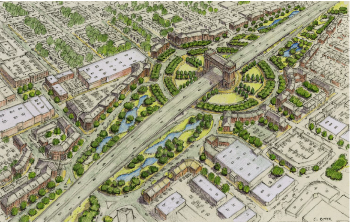
The ETRT, however, had far different plans for this segment. In May of 2016, using the resources of the ECI, they came out with a far-reaching and radical plan for transforming this segment into an attractive “gateway” entrance for Lafayette. The keystone of their proposal was a “grand circle” interchange for Willow Street where the Connector off/on ramps and the frontage roads would all come forth to a large circular roadway, with an arch-type building straddling the Connector mainline in the center of the circle. Smaller circle intersections would have been used for the Donlon/Walmart and Castille/MLK crossovers. A prototype design of what the ETRT/ECI proposed is below.


Alas, their forward thinking design was ultimately rejected by LADOTD, again citing both costs and traffic design criteria. (This would create more of the friction that always seemed to exist between the ETRT and the consultants, as we will explore in a future post.)
During the Tier II analysis, some of the LADOTD engineers did float the idea of using a “dogbone roundabout” design for Willow Street. Basically, a dogbone roundabout connects two circles together with the cross streets in the shape of a dog’s bone, so that traffic between the ramps and the cross streets can mesh together without the need for signalization. The heavy amount of traffic using Willow Street and the Thruway, though, mitigated against that design.
In the end, the consultants reverted back to the original design of a regulation slip-ramp diamond interchange for Willow Street. However, that didn’t mean they weren’t capable of thinking outside the box. Behold, the result:

Right away, you can see the radical changes they did:
1) The Castille Avenue/MLK Drive crossover is now a dogbone roundabout, with transitions to the one-way frontage road network and the existing two-way frontage roads along the Thruway, which are now retained for local access.
2) A new roundabout structure is now built just south of the Donlon Avenue/Walmart Drive crossover, allowing for direct access to the “Northside” Walmart store parking lot and Donlon via a connecting road. The existing Donlon/Walmart connection is converted into a RIRO (Right In Right Out Only) intersection with the Thruway frontage road.
3) The two-way frontage road on the east side of the Thruway is now directly connected to Chappius Street, but not to the northbound frontage road.
4) New north connection ramps are now introduced for access to the Thruway/Connector between Willow and the rail spur; braided with the south Willow exits, and meeting the south roundabout. This replaces the north connection ramps originally planned for Mudd Avenue/Second Street in the Tier II analysis, and effectively replaces the Second/Third and Johnston interchanges for downtown access in the 2003 ROD.
5) Finally, the Chalmette Drive crossover is eliminated, since the MLK/Castille roundabout will serve as the crossing to the other side of the freeway. This shortens the elevated section, saving money and also adding a longer lag for the I-10 exits/entrances.
Overall Impressions of Revisions
For the most parts, these revisions reflect LADOTD’s goals of getting the Connector built at the least cost, while balancing local concerns with the basic need to get this project designed as soon as possible. It certainly won’t flip any of the Teche Ridge Bypass advocates, who’d oppose any design going through downtown for any reason; and the frustration from some local groups and the ETRT from many of their ideas being rejected is palpable, but in a project as huge as this, you can’t please everyone.
The next milestone for the project should take place next month, when the End-to-End Alternative finalists will be introduced; first to the CSS Committees, and then to the public though a Public Meeting. They will then be vetted through public comment, revised for a Second Public Meeting, vetted again, and then the final three alternatives (2 Supplemental Alternatives and the 2003 ROD Alternative) will get a final vetting under the SEIS for selection of a Locally Preferred Supplemental Alternative by Lafayette Consolidated Government and the Acadiana MPO. Then, the Draft SEIS will be prepared and distributed for appropriate comments by the proper authoritiess; an official SEIS Public Hearing will be held for public comments on the Draft SEIS; and the Supplemental Selected Alternative will be finalized and approved through the Final SEIS and Supplemantal Record of Decision. After that, the SSA will be used to determine the final CSS design concepts; and, pending funding sources are found, the Connector will finally be built.
That is, pending the second round of lawsuits to negotiate through…