Dear Secretary Wilson:
I am someone who has followed intimately the progress of the I-49 Lafayette Connector freeway project since its inception; and I understand all of the controversy and battles that have ensued in the development of this project. Therefore, I can totally understand the frustration you must be feeling over the criticism that your agency and the consultants that you paid to direct the Conceptual Design/CSS/Supplemental EIS processes for this vital and important freeway project for Lafayette.
Nevertheless, I must take some bit of exception to your latest article that was posted at the Lafayette Connector website (and cross-posted to the Lafayette Advertiser), where you defend the current process against criticism from both Lafayette Consolidated Government officials and some in the public who question the depth of the current process.
I will use the text of your article as a foundation for my friendly rebuttal.
I will note from the beginning that I am and have been a strong and unswerving supporter of the Connector project alignment as approved through Lafayette, and am not a supporter of using any bypass alternative around the city, such as the Teche Ridge Bypass. In my view the Connector alignment is the most cost-efficient, most effective, and most balanced alignment for getting I-49 through Lafayette and completing the ultimate extension to New Orleans.
Nevertheless, even as a supporter of the current alignment, I find myself agreeing with the friendly yet critical editorial posted by the Advertiser that prompted your reply. There are several issues that I have with the current process and the implication that LADOTD and Lafayette Connector Partners are ignoring and dismissing the legitimate efforts of local groups and LCG agencies to improve upon the approved design concepts.
Here’s how your editorial rebuttal to the Advertiser began (The link to the original Advertiser editorial has been added by me; since it was added to the paper’s repost of your followup):
I was disappointed after reading an Editorial published by The Advertiser on Dec. 22, 2016, as the hard work of citizens and DOTD was dismissed by a failure to present facts and instead peddled misrepresentations.
It suggested “…a lack of interest from state officials about what local people have to say…”
FACT: We’ve held 30 Stakeholder Interviews, 29 Community, Technical, and Executive Meetings, 5 Public Meetings, and 24 structured interactions with various groups. As of today, 1,164 Public Comments are recorded with 6,360 recorded participant responses from the Vision and Values Workshop.
We’ve responded in earnest to the community’s feedback, altering schedules, designs and concepts to better reflect the desires and concerns shared with us. Questions regarding how community input is being used strike me as odd; the design concepts now under consideration are based on community feedback. These are Lafayette’s ideas, not DOTD’s.
This came at a cost, in both time and money, and was a necessary step to advance the project. If we were not interested, would we have undertaken such an effort just to reject all ideas? Absolutely not.
The “misrepresentations” you decry, Secretary Wilson, are actually legitimate concerns by Lafayette citizens and Lafayette Consolidated Government agencies that have been given less than an open chance to offer their alternatives to the design alternatives that have emerged from the Tier II analysis. The four proposed Concept Alternatives that your consultants produced do represent a response to feedback and critique from local officials…but, some can legitimately question whether these alternatives really address the objections and issues raised.
The biggest issue, in my view, is the dismissive attitude that the LCP consultants seem to have towards the Evangeline Thruway Redevelopment Team, the agency that was endowed by LCG with the goals of incorporating the Connector freeway within its environment and the neighborhoods that would be directly impacted by its footprint. Through the Evangeline Corridor Initiative program that was funded in large part through a US Department of Transportation TIGER grant, they have come up with their own proposals for designing the Connector to fully integrate with the central core of Lafayette. The ECI has the full endorsement and support of the LCG, and is fully empowered through the original Joint Cooperative Agreement that was endorsed by all agencies (DOTD, FHWA, and LCG) involved in the design of the project as part of the conditions of the 2003 Record of Decision approving this project.
And yet, in countless venues, the ECI’s proposals for improving and mitigating the footprint of the Connector freeway have been treated with at best a flippant “We’ll think about it” attitude, and at worst totally dismissed as irrelevant to the process.
The recent statement by new LADOTD Project Director Tim Nickel that the ETRT was not considered an “equal partner” in the Conceptual Design process, in spite of it being empowered by LCG, who is very much an equal partner, is testimony to the prevailing attitude of the consultants. It’s as if they are so offended that people like Kevin Blanchard, Robert Guercio, and the other members of the ETRT would dare to “invade their turf” in order to impose their idea on engineers…even if those ideas would have legitimate merit.
And, the alternatives for the central core produced by the consultants do indeed raise issues of how seriously LADOTD and LCP really do take legitimate friendly criticism.
It also suggested DOTD has already made up its mind about what I-49 will look like.
FACT: Since inserting significant time in the process, in response to the community’s request, significant changes have occurred that will change the outcome. The original plan now has 19 core area concepts with 25 potential design modifications being investigated for inclusion, many of which work well, add great value, and ALL of which have come from the public in this process. Some changes include eliminating interchanges and ramps, removing embankments, elevating structures, incorporating additional bike/pedestrian friendly elements, and enhanced protection of historic areas.
Based on the public response and technical evaluations, we narrowed the list of possible concepts down to two viable series: one based on an elevated structure and another based on a depressed/semi-depressed structure (proposed by a local advisory group).
As Secretary of DOTD, I assure you, we have not made decisions beyond what was originally approved in the original Record of Decision. We are trusting the process to determine which of those decisions will change and what they will become. However, no one should perceive that their participation guarantees their preferred outcome.
You are correct, Secretary Wilson, in saying that no decision has been officially made on what final design for the central core section of the Connector will be implemented. However, how else can we conclude that the evidence is a bit loaded towards a bare-bones Elevated option with the way that the alternatives that have been proposed are presented?
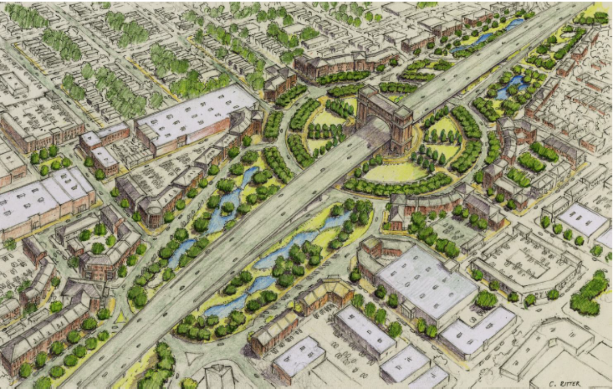
The Concept 4 alternatives, which are two variations of the Elevated option of a mainline Connector freeway on structure, use initial cost estimates that do NOT include any consideration of any of the following: (1) building a “signature bridge” design that has strong support locally; (2) raising the height of the elevated Connector mainline further than the standard 22 feet to 30 feet, if not the desired maximum of 40 feet; (3) any consideration of provisions for Complete Streets conversion of cross streets for alternative vehicular/bicycle/pedestrian accessibility and neighborhood connectivity; (4) consideration for additional grade-separated underpasses of the BNSF/UP railroad mainline that parallels the Connector other than the existing Jefferson Street underpass; and/or (5) consideration of retaining cross-street vehicular access near St. Genevieve Church and School and the Sterling Grove Historical District.
But, this pales in comparison to the Concept 6 semi-depressed alternatives (one open, the other a “cut-and-cover” full tunnel between Taft and Second Streets). This proposal is a magnitude different than the Partially Depressed and Covered Mainline proposal that the ETRT/ECI unveiled in August in response to LCP opening up the process for further “concept modifications”. That proposal called for a much less broad embankment than the Concept 6-2 “Cut-and-Cover” alternative; shifted the surface-level Evangeline Thruway frontage road system west to directly over the mainline as an avenue-type boulevard, and allowed for increased development on both sides of the boulevard as well as increased connectivity between the Freetown-Port Rico and McComb-Veazey neighborhoods through extending some streets over the mainline. It also was flexible enough to call for intermittent park decks to cover the freeway mainline at strategic places rather than a full tunnel.
It would be more acceptable that LCP ultimately rejected the ETRT’s proposed designs if adequate reasons and justifications were made transparent and public. Problem is, no logistics for justifying either LCP’s design for the Cut-and-Cover or the rejection of the ECI’s design are given; it is simply “assumed” that the LCP alternative is the final say for any depressed design.
This begs the question of whether LCP is even open to revising the Cut-and-Cover design to better integrate and give a proper vetting to alterations proposed by the ETRT/ECI. Considering the prevailing chilling attitudes thus far from the consultants, I have little hope. Given the heated response that Mr. Nickel had at the last CSS Community Workgroup Committee hearing last December to locals merely asking questions, that last bit of hope is sinking fast.
The public involvement process of the Connector study thus far has been pretty fair and inclusive…but also feels very top-down and enforced from LCP rather than truly interactive. People have complained about not being able to ask questions to CSS meeting presenters; and the format of the meetings not allowing for even written comments is a bit stifling. Unless this is changed, it will begin to feel like LCP and DOTD is imposing their choice on Lafayette rather than engaging in a true study; which not only dissolves trust in this project when it needs it most, but is an absolute gift to those who are fundamentally opposed to this project and would much prefer I-49 diverted around the city through the Teche Ridge Bypass.
There is also the issue of the former Southern Pacific Railroad railyard site, which was recently found to be a source of contamination of Lafayette’s drinking water. Federal and state laws would require a full remediation of that site before construction of the Connector would ensue; but the level of contamination and the impact of construction on the site is still to be determined. Is there any consideration, Secretary Wilson, for the need to initiate proper analysis and, if necessary, cleanup of that site to the benefit of protecting Lafayette’s drinking water supply? That is one of the main issues that could permanently block the Connector; it probably should be addressed soon, if not now.
It was suggested that “Too few people attend meetings, too little is known about how the information working group members provide to the DOTD is used.”
When compared to other communities with similar projects, public participation here is better than par, but par is never enough. Like many other public decision processes, such as city councils and elections, we all struggle with participation, which is why we use volunteer, appointed, and elected leaders.
As we are now nearing the end of the Tier II phase of the project, the information we get is validated and considered by technical experts and professionals based on public safety, engineering standards, constructability, and its alignment with previous decisions. The results of the technical analysis, both positive and negative, have all been shared with members of the CSS working groups, the bottom line being that semi- or fully depressed concepts are far more complex, expensive and problematic than an elevated mainline structure. This should not have come as a surprise, but it seems for those who preferred those designs, it has been a disappointment.
The problem with that assessment, Secretary Wilson, is that there is a distinct impression that the LCP consultants are rigging the game in favor of a bare-bones Elevated option, while not even considering either the ECI Partially Depressed-Covered Mainline proposal as they originally proposed, or not considering even alterations to the LCP proposal that could reduce the heavy costs included therein. What about shifting the Evangeline Thruway surface streets to directly above the covered mainline? What about a significantly reduced embankment on the east side of the mainline that would not require the entire current Thruway couplet ROW to be taken? What about shifting the connection ramps to allow for more connectivity and extending more streets over the freeway mainline? What about splitting the Johnston Street and Louisiana Avenue connection into two distinct streets rather than one connection in order to remove horozontal clearance issues? How about only capping the freeway at designated locations with park decks, leaving the majority of the faciity uncovered, resolving ventilation/light/emergency situations? For that matter, how about considering raising the railroad on structure at the same height of the cap of the freeway mainline, allowing cross streets to pass underneath the railroad unabated and removing both a major blockage and penetration of the Freetown-Port Rico Historical District?
I would think that given the strong support for the Partially Depressed-Covered Mainline alternative locally, DOTD and LCP would have a bit more respect for the local community and at least give these proposals a much fairer vetting before dismissing them outright.
I should note that I would have no objection to an Elevated Connector freeway, provided that as many, if not all, of the enhancements for CSS and connectivity proposed by the ETRT/ECI were fully incorporated into the final design and construction. I probably would be disappointed if a depressed freeway design couldn’t be implemented, but the need for building this project the right way supersedes any disappointment I’d have. I would be far more upset if the Connector wasn’t built at all or diverted.
As for meeting attendance….it probably appears to me that those who are against this project have simply made up their minds and are boycotting the process entirely. But, that doesn’t mean that there isn’t a real problem when friendly critics aren’t given a proper voice to speak their mind and give suggestions.
It stated, “…DOTD Secretary Shawn Wilson should step in and show leadership…”
FACT: Nearly one year ago, I agreed and authorized this process to become more open in its efforts. We expanded the process with the support of our federal partners. A characteristic of leadership is sharing decision-making responsibility and not dictating an individual opinion. Leadership is responsibly integrating data, best practices, and public opinion in a smart way to make a decision that is in the best interest for ALL involved. The Community, Technical, and Executive committees are part of a leadership structure that is working. With Lafayette’s Parish President and APC CEO, we have jointly led a public engagement process that is unprecedented for Louisiana, one that is changing the trajectory of this project in a good way.
I do think that in this case, Secretary Wilson, you should be given full credit for developing the process. The structure of the process is working fine; it’s the communication between the consultants and the locals that is needing repair. Yes, FHWA and DOTD is paying most of the freight for this freeway, but it will be Lafayette that will feel the full benefits and issues for this massive footprint; they have to feel they have a say in the final design.
It’s also stated, “DOTD is building mistrust here.”
After a nearly three hour CWG meeting, the facilitator ended the meeting, as the agenda had been exhausted. His closing of the meeting was not a rejection of ideas, just the end of a meeting that night. If that offended you, we apologize. Processes like these are not easy. They are frustrating and difficult, very complex. A perfect public process where everyone is happy and satisfied is a unicorn standing next to the pot of gold at the end of the rainbow, yet to be found. I will make judgment of DOTD’s effort and the process after all decisions are made. I trust the process and I trust the people that are at the table.
FACT: Trust in people and this process has already made this project better than when we started.
The problem with this is, Secretary Wilson, that Mr. Nickel’s abrupt cancellation of the CWG meeting last December was not the first time that LCP consultants have had to clean up some controversy. Remember when the first Project Director, Toby Picard, posted a letter challenging some members of the CWG to resign because they had suggested building a boulevard in lieu of the Connector freeway? I supported that action because it looked like Connector opponents were infiltrating the process to deliberately sabotage it with their “boulevard only” option, and only screamed about “censorship” when they were caught and called out. In addition, it was local reaction to the ETRT’s initial ideas not being included in the original 19 Refinement Alternatives that prompted Picard, after first initially dismissing ETRT as “irrelevant”, to modify the process to the current evolution today.
Certainly, in the design and evolution of a project as massive as the I-49 Lafayette Connector freeway, everyone will not get their way. It is still necessary for those who are developing this project to at the very least be transparent in their intentions, and give solid, understandable, and accurate analysis in ultimately designing and constructing this vital project. Anything else gives rocket fuel to the Sierra Club/Y-49/TecheRidgePlusBoulevard lobby who is more than itching for a legal rematch to stop this project and get their way. If you support this project as I do — and I am sure, Secretary Wilson, that you do — there needs to be a lot more listening on everyone’s part. We have one shot only to make the Connector work, so let’s do it right.
Yours sincerely,
Anthony Kennerson
