A New Connector Update: Revised Designs Released For Proposed Tier III/SEIS Alternatives; Final End-to-End Alternatives Forthcoming

After nearly 2 months of analysis and tweaking of design, the I-49 Lafayette Connector freeway project is beginning to finally take its ultimate form. But, not without the usual controversies.

Last week, two of the I-49 Connector CSS committees (Community Work Group and Technical Advisory Committee) held meetings where the consultant group overseeing the design of the project (Lafayette Connector Partners) in conjunction with the LADOTD and FHWA) revealed some revisions they made to the original design approved in 2003. Earlier in July, they had revealed a major tweak to the proposed interchange between the Connector and Kaliste Saloom Road; this time, they covered the remaining segments of the project all the way to just short of Interstate 10.

The design changes are meant to move towards analysis of two finalist “End-to-End Alternatives” that will undergo the final evaluation of a Supplemental Environmental Impact Statement (SEIS) study in order to produce a Supplemental Selected Alternative for final approval by FHWA and LADOTD. The original approved alternative from the 2003 Record of Decision generated from the October 2002 Final EIS will also be analyzed, but only as a control for comparison purposes with the other two alternatives.

The tweaks for the Kaliste Saloom Road interchange were already covered in my previous post; we’ll start from there northward.


University Avenue/Surrey Street/Pinhook Road

In the original concept approved in the 2003 ROD, the mainline Connector freeway would have a direct interchange with University Avenue/Surrey Street in order to provide access to Lafayette Regional Airport. A conflict with the overpass over University/Surrey cutting into the flight path of Runway 11-29 would be resolved by displacing the runway 350 further down, through extending it at its eastern end; thus allowing the overpass to be built to normal vertical clearances. Frontage roads paralleling the existing mainline Evangeline Thuway south of Pinhook Road would provide local access, while the mainline would be converted to freeway standards. The frontage roads would then transition to the existing Evangeline Thruway one-way couplet. No interchange would be built at Pinhook due to the proximity of University/Surrey nearby.

Original 2003 ROD concept of I-49 Connector freeway in Lafayette from University Avenue/Surrey Street to north of Fourteenth Street/Taft Street. (via Lafayette Connector website)

You will notice how the southbound Thruway frontage road brushes through the periphery of the newly created Freetown-Port Rico Historic District, which was established after the initial ROD was finalized. Also, this concept assumed a full interchange at Johnston Street (just beyond the scope of this segment).

Because of the desires of the local community to eliminate the Johnston Street interchange and open up more connectivity for both the Freetown and the neighboring McComb-Veazey neighborhoods, the initial Tier I and II studies focused on switching access between the Connector and downtown Lafayette to “connection ramps” using the existing Evangeline Thruway. In the proposed concept that came out of the Tier II studies, the connection ramps from/to the south would hook up with the Thruway at Eleventh Street, and the southbound frontage road would be realigned to remove any direct impacts on homes in the FTPR District.

Concept 4.2 from Tier II Study, with emphasis on south connection ramps between mainline Connector and Evangeline Thruway at Eleventh Street. (via Lafayette Connector website)

Apparently, though, that still created too much of an issue with the houses fronting the Thruway within Freetown, because what the consultants ended up with for their ultimate revision became radically different from what came before.


Revised design for I-49 Lafayette Connector freeway between University/Surrey and Taft, featuring new interchange with Pinhook Road.

The “interchange” with Pinhook Road is created by shifting the south connection ramps to/from the Evangeline Thruway to south of Pinhook as “slip ramps”, and moving the north off/on ramps that would have served University/Surrey north of Pinhook and over Taft Street.

The other radical revision is that the Pinhook intersection with the Thruway is converted to a “reduced phase” intersection, where the left turn movement from northbound/westbound Pinhook to southbound Evangeline Thruway/I-49 is segregated further out from the actual intersection. Because of that, some side streets that connected to Pinhook would have to be revised or even cut off, and access to some businesses fronting the Pinhook/Evangeline Thruway intersection would be constrained or have to be revised. Chag Street, for example, would have to end in a cul-de-sac rather than intersecting with Pinhook; and other streets would have to have their access to Pinhook altered.

The other major change shown here is that University Avenue/Surrey Street is now depressed in order to lower the profile of the Connector overpass located therein; this removes the conflict with LFT’s Runway 11-29. (The displacement that would have been used for the Connector freeway was overridden by a mandate from the Federal Aviation Administration for Emergency Materials Arrestor Systems (EMAS) extensions for runways to protect aircraft from overruns.)

Another minor adjustment is the addition of a local extension of Drain Street paralleling the southbound Thruway roadway to serve houses in Freetown fronting the Thruway. This is neccessary due to control of access standards caused by the ramp serving the new Pinhook “interchange”, and mitigating the impacts to the FTPRHD.


Downtown Core Area (Taft Street to L&DRR Rail Spur)

This is the segment that has generated the most controversy and debate, and has effected the greatest design variations.

First, the original concept from 2003:


Original 2003 ROD design of Connector freeway in central downtown Lafayette.

Two standalone direct interchanges (with adjacent railroad underpasses) with Johnston Street and the Second Street/Third Street couplet to serve downtown; the Thruway remaining in its present couplet form; Simcoe Street and Jefferson Boulevard depressed to maintain connectivity underneath the elevated freeway, and the northbound Thruway realigned from Jefferson northward away from the Sterling Grove Historic District. A decent and acceptable concept, right?

Not for the locals in Lafayette, it wasn’t. They didn’t like the loss of possible property from the two interchanges for development, nor the lost opportunities for reconnecting downtown with the surrounding neighborhoods. The section of at-grade mainline between the elevated segments didn’t satisfy them, either.

It was these objections that motivated the Evangeline Thruway Redevelopment Team — the organization launched by local city government to mitigate the overall impacts of the Connector — to promote their alternative designs. In the end, their Evangeline Corridor Initiative group produced two concepts: an Elevated Mainline with a Signature Bridge, and a Partially Depressed and Covered Mainline featuring a “cut-and-cover” section paralleling the Thruway and the BNSF/Union Pacific main rail line. The latter option was studied and refined by the LCP, but ultimately was rejected due to costs and drainage issues.

Partially Depressed and Covered Mainline concept for I-49 Connector as proposed by the Evangeline Thruway Redevelopment Team (ETRT) via their Evangeline Corridor Initiative (ECI).
Elevated with Signature Bridge concept proposed by ETRT/ECI.
Elevated with Evangeline Thruway Couplet (Concept 4.1) proposed by LADOTD/LCP via Tier II Process.
Elevated with Evangeline Thruway as Grand Boulevard (Concept 4.2) introduced by LADOTD/LCP after Tier II analysis.

The most significant alterations were done near Sterling Grove and the St. Genevieve Catholic Church; where proposals for severing access to the Sterling Grove Historical district from the Evangeline Thruway/frontage road system, as well as shift access from Simcoe Street to the Second/Third couplet were met with strong opposition due to disconnecting Sterling Grove from the west. The north “connection ramps” to the Thruway also had a potential visual impact to the St. Genevieve Church. Shifting the north connection ramps to north of Mudd Avenue was an option, but that got opposition from Sterling Grove HD residents fearing that that would send heavy traffic through their district.

In the end, apparently, LADOTD threw their hands up and said, OK…you get what you want, here’s nothing. This is what they came up with finally.


Revised design for Connector freeway in downtown Lafayette core, circa September 2017.

Essentially, the Connector just floats over the existing status quo downtown. No exits or entrances until you get to the Pinhook/University/Surrey southbound or the Willow Street interchange northbound. No adjustments to the existing Thruway (the Grand Boulevard option notwithstanding, although there is another option not shown here where the Thruway uses the existing couplet, with a realignment to the west from Jefferson Street northward on the northbound roadway to get some distance away from Sterling Grove).

So, with all that, how does traffic entering southbound access the Thruway and downtown? Don’t worry….they planned for that.


Rail Spur to I-10 (Including Donlon Avenue/Northside Walmart Connection, Willow Street Interchange, and Castille Avenue/MLK Drive Connection)

First, let’s take a look at the 2003 ROD schematics:


Original 2003 ROD design for I-49 Connector from the rail spur to I-10, including the Willow Street Interchange.

Under the original design, the elevated mainline would be extended above Donlon Avenue, Willow Street, and the crossovers at Castille Avenue/Martin Luther King Drive and Chalmette Drive before finally lowering at-grade to terminate just before the I-10/I-49 interchange. Full intersections would be built to replace the 3/4th intersections at Donlon Avenue/Walmart Drive, Castille/MLK, and Chalmette; the latter would be where the one-way frontage road network would end an transition into the existing two-way local frontage road network. Slip ramps would provide access between the freeway and the one-way frontage roads/Thruway couplet at Willow Street.

The ETRT, however, had far different plans for this segment. In May of 2016, using the resources of the ECI, they came out with a far-reaching and radical plan for transforming this segment into an attractive “gateway” entrance for Lafayette. The keystone of their proposal was a “grand circle” interchange for Willow Street where the Connector off/on ramps and the frontage roads would all come forth to a large circular roadway, with an arch-type building straddling the Connector mainline in the center of the circle. Smaller circle intersections would have been used for the Donlon/Walmart and Castille/MLK crossovers. A prototype design of what the ETRT/ECI proposed is below.

North Lafayette Gateway utilizing a Willow Street Circle Interchange, proposed by Evangeline Corridor Initiative.
Another view of the North Lafayette Gateway Arch design for the Willow Street Interchange, as proposed by the ECI.

Alas, their forward thinking design was ultimately rejected by LADOTD, again citing both costs and traffic design criteria. (This would create more of the friction that always seemed to exist between the ETRT and the consultants, as we will explore in a future post.)

During the Tier II analysis, some of the LADOTD engineers did float the idea of using a “dogbone roundabout” design for Willow Street. Basically, a dogbone roundabout connects two circles together with the cross streets in the shape of a dog’s bone, so that traffic between the ramps and the cross streets can mesh together without the need for signalization. The heavy amount of traffic using Willow Street and the Thruway, though, mitigated against that design.

In the end, the consultants reverted back to the original design of a regulation slip-ramp diamond interchange for Willow Street. However, that didn’t mean they weren’t capable of thinking outside the box. Behold, the result:

Revised design for the I-49 Connector freeway from the L&DRR rail spur to I-10.

Right away, you can see the radical changes they did:

1)  The Castille Avenue/MLK Drive crossover is now a dogbone roundabout, with transitions to the one-way frontage road network and the existing two-way frontage roads along the Thruway, which are now retained for local access.

2) A new roundabout structure is now built just south of the Donlon Avenue/Walmart Drive crossover, allowing for direct access to the “Northside” Walmart store parking lot and Donlon via a connecting road. The existing Donlon/Walmart connection is converted into a RIRO (Right In Right Out Only) intersection with the Thruway frontage road.

3) The two-way frontage road on the east side of the Thruway is now directly connected to Chappius Street, but not to the northbound frontage road.

4) New north connection ramps are now introduced for access to the Thruway/Connector between Willow and the rail spur; braided with the south Willow exits, and meeting the south roundabout. This replaces the north connection ramps originally planned for Mudd Avenue/Second Street in the Tier II analysis, and effectively replaces the Second/Third and Johnston interchanges for downtown access in the 2003 ROD.

5) Finally, the Chalmette Drive crossover is eliminated, since the MLK/Castille roundabout will serve as the crossing to the other side of the freeway. This shortens the elevated section, saving money and also adding a longer lag for the I-10 exits/entrances.

Overall Impressions of Revisions

For the most parts, these revisions reflect LADOTD’s goals of getting the Connector built at the least cost, while balancing local concerns with the basic need to get this project designed as soon as possible. It certainly won’t flip any of the Teche Ridge Bypass advocates, who’d oppose any design going through downtown for any reason; and the frustration from some local groups and the ETRT from many of their ideas being rejected is palpable, but in a project as huge as this, you can’t please everyone.

The next milestone for the project should take place next month, when the End-to-End Alternative finalists will be introduced; first to the CSS Committees, and then to the public though a Public Meeting. They will then be vetted through public comment, revised for a Second Public Meeting, vetted again, and then the final three alternatives (2 Supplemental Alternatives and the 2003 ROD Alternative) will get a final vetting under the SEIS for selection of a Locally Preferred Supplemental Alternative by Lafayette Consolidated Government and the Acadiana MPO. Then, the Draft SEIS will be prepared and distributed for appropriate comments by the proper authoritiess; an official SEIS Public Hearing will be held for public comments on the Draft SEIS; and the Supplemental Selected Alternative will be finalized and approved through the Final SEIS and Supplemantal Record of Decision. After that, the SSA will be used to determine the final CSS design concepts; and, pending funding sources are found, the Connector will finally be built.

That is, pending the second round of lawsuits to negotiate through…

Finally, A Fresh Connector Update: Tier III Studies Now Underway; LFT Airport Runway Issues Resolved; New Design For University/Surrey & Kaliste Saloom Interchanges, And More

Well..after three months of what seemed to be inaction, the I-49 Connector Concept Refinement Process/Supplemental Environmental Impact Statement/CSS Design processes seem to be back in action now.

On Wednesday and Thursday, two of the Connector CSS Committees – Community Work Group on Wednesday and Technical Advisory Committee on Thursday – had their first meetings in three months to get an update from the Lafayette Connector Partners consultant team on progress with the project. In case you have missed it, the LCP team recently got their contract extended for another 2-1/2 years in order to complete the Supplemental EIS and produce a new revised alternative to the freeway design approved in 2003.

The main points that came across from the meetings can be summarized below.

First, some major design tweaking was finalized on the southern section near Lafayette Regional Airport, in response to some major issues that had to be resolved.

The original concept passed by the 2003 ROD assumed that one of the LFT runways (Runway 11-29) would have to be displaced by 350 feet to allow for a regulation design for the University Avenue/Surrey Street overpass of the Connector mainline to avoid violating that runway’s flight path. In October of last year, however, the Federal Aviation Administration (FAA) imposed new rules requiring airports to install Emergency Materials Arrestor Systems (EMAS) runway extensions to prevent overruns of aircraft; this would have potentially added an additional 300 feet of runway extension to the already planned 350 feet displacement that would have been required for the Connector freeway.

Given that such an addition would have required taking far more wetlands than would have been proposed, the FHWA and the LCP was forced to reassess the design for the University/Surrey interchange and develop alternatives that would not require the runway displacement. This is required because Section 404 regulations are pretty tough on displacing wetlands.

The alternatives discussed included:

— Lowering the profile of the Connector freeway overpass over University/Surrey so that the existing flight path (without the 350′ runway displacement) would be retained. This would be accompanied by lowering the grade of University/Surrey to allow standard vertical clearance below the underpass.

— Shifting the design of the University/Surrey interchange so that University/Surrey would pass over the Connector freeway on a partially elevated structure, while the Connector mainline would be partially depressed to cross underneath University/Surrey.

— Shifting the alignment of University/Surrey sightly to the north to move the interchange further away from the glide path of Runway 11-29. This would, however, come with some major issues of taking land from Beaver Park, which is a Section 4(f) property, and potentially taking access from a boat launching facility for Beaver Lake, which would be a potential Section 6(f) violation. Both 4(f) and 6(f) regulations require that alternatives be taken to prevent taking of protected resources.

Ultimately, it was decided that the best and most cost efficient course was Option #1: reduce the profile of the Connector overpass and lower University/Surrey. This effectively removes the risk to Runway 11-29’s glide path and allows for the EMAS extensions to be implemented.

Another significant change was the revision of the design for the proposed Kaliste Saloom Road interchange. The original design approved by the 2003 ROD called for a 3-way fully directional interchange with flyover ramps over the Connector mainline and BNSF/UP railroad mainline. The highest ramp (from northbound Kaliste Saloom to the northbound frontage road and northbound Connector mainline) would be up to 40 feet high. Here’s an illustration graphic of the original proposal (from the presentation given at the latest meetings, via the Lafayette Connector website):

Also notice how the original design had the southbound frontage road wrap around the back of the Acadiana Dodge car dealership, and how the original ramps and access road connecting Kaliste Saloom Road and Hugh Wallis Road conflict with a hotel establishment that was recently built.

In its place, the LCP design team created an interesting alternative design which reduced both the ROW required and the height of the interchange. The flyover ramps are replaced by a single structure where the left turning movements (from east bound Kaliste Saloom Road to northbound Evangeline Thruway/I-49 and from northbound I-49 frontage road to westbound Kaliste Saloom) meet and cross each other at grade, similar to a Single Point interchange. In addition, the connecting access road between Kaliste Saloom and Hugh Wallis is shifted south to parallel the new Kaliste Saloom overpass structure, and split into two roadways which connect to Kaliste Saloom Rd. via RIRO (Right-In-Right-Out) connections just east of the Episcopal School of Acadiana entrance.

The new design also shifts the southbound frontage road to flank the Connector mainline, passing in front of Acadiana Dodge rather than behind it. There was some concern that such a design would require taking the showroom of the dealership, but apparently that has been resolved.

In addition to these changes, the LCP team also addressed which Potential Design Modifications (PDMs) would advance into the Tier III process. The page below lists all the PDMs considered. The ones highlighted in black are the ones that advanced into Tier III and will be incorporated into the End-to-End Alternatives to be studied in the SEIS; the red highlighted ones are those that were totally rejected; and the blue highlighted ones were to be further negotiated and discussed.

The most striking aspect about this list is that the blue highlighted PDMs that remain to be resolved all have to do with enhancements desired by Lafayette Consolidated Government to mitigate the impact of the Connector through the central core of Lafayette, but which by law the Federal and state government couldn’t fund directly as part of the project. This means that if LCG wants to have a signature bridge or pedestrian walkways or a higher clearance for the elevated structures, they would have to find the revenue to pay for it. That may be a significant sticking point, considering the paucity of funding and the general attitude against taxation.

Another real sticking point comes around the rejection of PDM #23-7, a proposed “dogbone roundabout” design for the Willow Street interchange.  The Evangeline Corridor Initiative, a project of the Evangeline Thruway Redevelopment Team that was paid for by a Federal TIGER Grant, had proposed a different interchange design for Willow: a large rotary circle interchange in which an arch-like structure would straddle the elevated mainline to serve as a gateway for North Lafayette.

The LCP design team, though, had blown off the ECI’s proposal in favor of studying the “dogbone roundabout” design, which they have developed and implemented in other areas. Their traffic studies found that such a design would not work for Willow Street due to heavy turning volumes between Willow Street and the Evangeline Thruway/Connector, and pretty much recommended the original “slip ramp” diamond interchange design approved by the 2003 ROD.

Obviously, representatives of the ECI were not too happy, as seen in this snippage of coverage of the meetings from the Lafayette Advertiser:

Kevin Blanchard, who sits on the Evangeline Thruway Redevelopment Team working for the city to improve the Evangeline Thruway area in conjunction with the I-49 project, was surprised to learn the ETRT’s plan for a rotary circle with signature feature at Willow Street has been scrapped by the I-49 planners.

The I-49 Connector will be elevated as it crosses Willow Street, a gateway into the city. Blanchard said the ETRT team proposed a large rotary circle with a gateway feature such as an arch that would add value to the urban space.

Blanchard asked for a comparison of traffic volumes expected in a roundabout versus a rotary circle.

“We’re talked in this process about partnering with locals,” he said. “Let’s look at what was proposed locally, which was not a roundabout. It is one of the priorities of the ETRT.”

This isn’t the first time that the ETRT has clashed directly with the Connector planners; it took the ECI to force the LCP and LADOTD to even consider the Partially Depressed/Cut and Cover options for Tier II, only to have it removed from further consideration with great consternation in Feburary.

The next steps for the LCP will be to finalize and introduce to the public the End-to-End Alternatives, that will then be refined and reduced to two finalist Supplemental Alternatives, which will then be fully vetted through the Supplemental EIS process. The original 2003 EIS/ROD Selected Alternative will also be included, but only as a control for comparison to the others. It’s assumed that a Supplemental Preferred Alternative would be presented prior to the release of the Draft SEIS, probably by spring of next year, with a Final SEIS/Supplemental ROD approved by fall of 2018, and the remainder of the Corridor Functional Plan process involving finalization of the CSS design elements finished by October of 2019.

Unless, of course, the Sierra Club and Citizens for Good Government decide to intervene with their inevitable lawsuit challenging the SEIS/SROD for threatening the Chicot Aquifer and pushing for their favored Teche Ridge Bypass.

As always, I’ll break in this space here with any further developments.

May 2017 Update: Contract For Connector Studies Extended Until October 2019 To Complete Supplemental EIS, Select New Alternative

An interesting turn of events has occured this past two months concerning the I-49 Lafayette Connector freeway studies.

The Lafayette Independent recently obtained via the Freedom of Information Act inquiry a copy of a new Supplemental Agreement that was signed by both the Louisiana Department of Transportation and Development and the lead consultant agency Stantec for the project. This new agreement extends the existing contract for engineering and environmental study and the Conceptual Design and Context Sensitive Solutions (CSS) processes from its current termination of June 2017 to October 2019.

A copy of the Supplemental Agreement and its associated appendices is below (via Scribd.com):

The 28 month extension is essentially to allow for a full process of initializing, developing, and completing a Supplemental Environmental Impact Statement (SEIS), which the Federal Highway Administration (FHWA) had deemed to be necessary due to the substantial changes in the environment in Lafayette surrounding the project, as well as the design modifications sought by local Lafayette stakeholders and the public.

According to the terms of the Supplemental Agreement, LADOTD, FHWA, the Connector consulting crew (organized under the label Lafayette Connector Partners (LCP)), and the Lafayette City-Parish Consolidated Government (LCG), will coordinate and organize new studies, analysis, and public interaction using the same 3-tier evaluation approach as used under the current Concept Refinement Process (CRP). That process was launched in January of 2016 due to the desire of stakeholders in Lafayette to modify the design of the alternative approved in the original 2003 Final EIS/Record of Decision in order to mitigate the footprint along the neighborhoods directly affected.

Originally, the CRP had produced an initial group of 19 Conceptual Design Alternatives (CDAs) utilizing 6 design concepts for the central section of the Connector freeway between Pinhook Road and the Louisiana & Delta Railroad spur rail line; complemented by 25 spot Potential Design Modifications (PDMs) along the entire length of the corridor from just south of Lafayette Regional Airport to just south of the I-49/I-10 interchange. This was analyzed under the Tier I evaluations, and reduced to 4 concept alternatives (2 “Series 4” elevated;  2 “Series 6” partially depressed), which along with the PDMs were further vetted through the Tier II analysis.

Under the newly refined process under this extended agreement, the remaining Tier II analysis would be finalized and six “hybrid” or “End-to-End” alternatives would be produced to advance into the Tier III more detailed environmental evaluation and to begin the SEIS process. This would result in two finalist Supplemental Alternatives which would undergo the full SEIS process vetting for environmental impacts. The original approved 2003 ROD alternative would also be included, but only as a control for comparison purposes.

A Supplemental Preferred Alternative would then be produced which would be sent first to LCG (via the City-Parish Council) and the Acadiana Metropolitan Planning Organization (Acadiana MPO) for review and ratification, and then presented in the Draft SEIS for review by the FHWA, relevant federal, state, and local agencies, and ultimately public comment via an official Public Hearing. Based on the feedback, a Final SEIS presenting the Selected Supplemental Alternative would be produced and reviewed, leading to a Supplemental ROD stating final approval. Then the original CSS/Conceptual Study scope would kick back in for detailed design features and developing the Complete Functional Plan for elements within and surrounding the corridor.

There are some very interesting aspects to be found in this modified process, and the agreement does reveal some new information not made public before.

The recent induction of the Freetown-Port Rico neighborhood as a Historical District has forced some minor alteration of design for a segment of the freeway near Pinhook Road, where the southbound Evangeline Thruway roadway serves as the boundary for the newly formed district. Some homes facing the southbound Thruway from Fifteenth to Pinhook along the FTPRHD would possibly be adversely impacted by the proximity of the elevated structure or control of access requirements, which would prompt a flag under Section 4(f) protocols.

Another more major conflict occurs at the proposed interchange with University Avenue and Surrey Street near the Lafayette Regional Airport (LFT). The original interchange design for the 2003 ROD approved alternative was based on a 350 foot displacement of a runway at LFT in order for the glide path approach to successfully clear the vertical height for the elevated overpass over University/Surrey. However, in 2016, the Federal Aviation Administration imposed new rules for airports requiring additional runway extension space for incorporating EMAS (Engineered Materials Arrest Systems) to prevent runway overruns. This added an additional 300 feet to the proposed 350 foot extension, which would cause a much more serious impact to wetland areas and Bayou Tortue. Therefore, new alternatives for the University interchange that would not require the runway displacement had to be developed, creating new issues and opportunities. A new proposal that would realign the University/Surrey interchange slightly northward to avoid impacting the glide path introduces 4(f) takings of Beaver Park near Beaver Lake, and could potentially flag 6(f) takings of a boat access ramp serving Beaver Lake. A University/Surrey overpass of a partially depressed I-49 mainline is also under consideration.

A third conflict that has developed involves the Kaliste Saloom Road interchange just south of the airport; a hotel was built on Hugh Wallis Road near the Walls Estate property that would affect the geometry of the on-ramp from the Connector southbound to Kaliste Saloom Road, as well as a local connector road that would replace the at-grade connection betweet Kaliste Saloom and Hugh Wallis.  Adjustments to the ramps would have to be made; and possibly even alterations to the design of the directional interchange.

The most significant issue to date, however, is the Connector’s crossing of the site that was formerly the old classification and maintenance yard for Southern Pacific Railroad. That site has been the target of litigation for allegedly being a hazardous waste producer that has contaminated both the soil and potentially the drinking water supply through the Chicot Aquifer, which runs nearly 40 to 60 feet under the city. Environmental Assessments have been done for the rail yard site, and further evaluation for remediation and cleanup will be done as part of the SEIS; nevertheless, it has become the main flash point for those who oppose the project in its entirity. On the other side of the debate, the Evangeline Corridor Initiative (ECI) has also targeted the site for future development upon cleanup as a means of reconnecting the Freetown-Port Rico and McComb-Veazey neighborhoods, through additional cross streets underneath the Connector freeway. That would also require shifting the south connection ramps linking the Connector mainline to the Thruway, currently proposed at Eleventh Street, to be shifted further southward or eliminated altogether.

The original issue of how the Connector would impact the adjacent Sterling Grove Historical District as it crosses just near downtown is still very much involved. The most recent proposals would shift the northbound Evangeline Thruway roadway further west away from the perimeter of Sterling Grove and St. Genevieve Catholic Church/School, but would also sever Mudd Avenue east of the Thruway and Simcoe Street by diverting its traffic onto the Second/Third Streets couplet and Chestnut Street. (The latter would allow for connection slip ramps to be built to link the Connector mainline to the Thruway frontage system at Second Street.) The ECI and locals would prefer to keep Simcoe and Mudd open and continuous, and shift the north connection ramps to just north of Mudd Avenue.

Finally, there is the north section from the L&DRR to I-10, where the ECI has developed an ambitious and striking plan to convert the corridor into a “gateway” for travelers coming into Lafayette. The original plan under the 2003 ROD was for the Thruway to evolve into a parallel frontage road system, with slip ramps connecting the mainline with the frontage roads making up the Willow Street interchange for local access. The ECI’s proposal, however, would replace that with a large traffic circle interchange, where Willow Street, the frontage roads, and the freeway ramps would integrate with each other using the super “roundabout”. (The image at the top of the home page of this blog illustrates the ECI’s “North Gateway” proposal.) Smaller circles tying into the Willow Circle would be developed at the intersection where the frontage roads meet Martin Luther King Drive/Castille Avenue and the intersection of the frontage roads with Donlon Avenue/the access road to the Lafayette Northside Walmart Supercenter store (“Walmart Drive”). For its worth, the LADOTD has proposed its own counter design for the Willow interchange, based on their “dogbone roundabout” design. Analysis and a final decision on design will be part of the SEIS/CFP process.

Other processes that would have to be resolved and finalized under the new SEIS process are as follows: Updating the Section 106 Historical Resources analysis and issuing a revised Memorandum of Agreement for mitigation plans for Sterling Grove and Freetown-Port Rico; revised and updated geometry to reflect increases in traffic counts; updated traffic modeling to compute traffic data for existing conditions, 2040 design year conditions both with and without the Connector built, and determining the scope of traffic modeling for the Thruway section downtown whether it remains a coupled or is converted into a “grand boulevard”; and adding additional public feedback, including two new SEIS Public Meetings and the official Draft SEIS Public Hearing.

The original three committee CSS approach (Community Work Group, Technical Advisory, and Executive) for vetting and approving elements of the process would continue under this new agreement.

All in all, everything has been basically pushed forward to hopefully streamline and improve the process. Let’s see what happens.

A Long Overdue Connector Update: Tier II Studies Winding Down; Elevated Option Apparently Chosen By LADOTD/FHWA; LCG/ETWT Protests; Opposition Seethes And Preps For War

My apologies to you all for it being so long for an update to this blog; but life happens, as it is. (Until it isn’t.)

Things are beginning to happen right now with the I-49 Lafayette Connector freeway project that will have major ramifications down the road for the Conceptual Study and Supplemental Environmental Impact Statement (SEIS) processes now ongoing. Here’s what has happened since we last met.

On Friday, March 10th, the Executive Committee for the consultant group Lafayette Connector Partners, who has been contracted by LADOTD and FHWA to oversee the Conceptual Design and SEIS processes, held an impromptu meeting after nearly two months of inaction. The stated purpose was to provide an update on the process ongoing; but it ultimately created some degree of fireworks for some changes in the process that were made.

For those not quite in the know: the Connector Conceptual Design Study process utilizes a three committee approach for analysis and decision making. The Community Work Group (CWG) is responsible for hashing out ideas for specific design features for the freeway project; the Technical Advisory Committee (TAC) provides technical support through detailed studies; and the Executive Committee (EC) makes final decisions based on the input and analysis of the other two groups. The EC includes the major leads for all the governmental entities involved in the project, including Transportation Secretary Shawn Wilson (who also just so happens to be a Lafayette native, a graduate of what was then USL (now ULL) who worked engineering on the Connector project during the initial stages); LADOTD Lead Engineer Tim Nickel; and Lafayette City-Parish President Joel Robideaux.

In addition, because of the fact that the Record of Decision approving the current Connector alignment is over 10 years old, a reevaluation of the approved Selected Alignment had to be done to update potential impacts to the community. In response to feedback from the locals who didn’t like what the 2003 ROD Selected Alternative offered them, the process was altered to allow for some major design alterations and modifications; and to offer new design alternatives. Hence, a Supplemental EIS was also called upon to reflect and analyze the modifications to the 2003 Selected Alternative, and to select a modified design alternative to proceed further.

At this point, the studies are nearing the conclusion of the Tier II analysis for both the design alternative concepts and the specific design modifications originally developed and analyzed during the Tier I process.

Thus far, the main focus has been on vetting and analyzing the proposed concepts for the core segment of the Connector freeway between Pinhook Road and the crossing of the Louisiana & Delta Railroad Breaux Bridge spur, that would pass through the heart of Lafayette along the Evangeline Thruway. What started out as 19 Conceptual Design Alternatives utilizing five concepts at the start of Tier I has now been reduced to 4 conceptual alternatives utilizing two “series” of design concepts. Two alternatives reflect the “Series 4” concept of an continuously elevated mainline freeway; while the other two reflect the “Series 6” concept of a freeway mainline partially depressed 10 feet with cross streets passing over the freeway on embankment.

Original Selected Alternative from 2003 EIS/ROD, used as a control for the other alternatives in this CDS/SEIS process.
Concept 4.1: Elevated Option with the Evangeline Thruway generally remaining in its present one-way couplet; indirect connections via ramp pairs to the Thruway.
Concept 4-2: Elevated Option, but with Evangeline Thruway repurposed as a “Grand Boulevard” using current southbound ROW. (Northbound Thruway reverts to local street within grid.)
Concept 6-1: Semi-Depressed Mainline with major crossing streets passing over freeway; Johnston Street overpass of freeway and BNSF/UP railroad mainline.
Concept 6-2: Semi-Depressed Mainline, but with the freeway covered through a “cut-and-cover tunnel” design allowing cross streets to pass over the tunneled mainline via embankment.

The Concept 6 series was developed mostly in response to the stated criticism from the Evangeline Thruway Redevelopment Team (ETRT). This group was created by Lafayette Consolidated Government to develop and implement means to reduce and mitigate the footprint impact of the Connector freeway on the neighborhoods it would pass through and near. The ETRT, empowered by a federal Department of Transportation TIGER Grant, undertook detailed analysis and public feedback from locals on how to best integrate the Connector into the community, while retaining interneighborhood connectivity and better access for alternative transportation means than just vehicles (as in bicycling and walking). Based on their studies, they came up with two alternative concepts of their own for the Connector; utilizing the same “series” concept as the CDS Tier II alternatives.

ETRT/Evangeline Corridor Initiative conceptual design for Elevated Mainline freeway; note the special design for the Willow Street interchange which would allow for an Arc de Triumph-inspired circle plaza in the middle of the ROW as a gateway for Lafayette.
A closer view of the ETRT/ECI Elevated Mainline crossing through Downtown/Freetown-Port Rico/McComb-Veazey. This includes the Evangeline Thruway converted into an “grand boulevard” on its southbound ROW.


ETRT/ECI conceptual design for Semi-Depressed and Covered Mainline, with the Evangeline Thruway mainline shifted to directly over and/or flanking the capped freeway, as compared to the Concept 6-2 alternative from LADOTD/LCP.
A closer view of the ETRT/ECI SD/C Mainline alternative passing through Downtown/Freetown-Port Rico/McCovey-Veazey.

In addition to proposing design changes, the ETRT was also empowered by the Lafayette Consolidated Council to negotiate with the LADOTD and FHWA the terms of how the refinements in streetscaping and walkability/bikeability would be funded as part of constructing the Connector. FHWA and LADOTD policy allows for them to fund the bulk of the construction of amenities for mitigating impacts of the project; but many of the neighborhood amenities sought for by ETRT would probably have to be funded locally since that would be outside the immediate ROW impact.

That process has rubbed some nerves raw locally, since there is the fear that due to revenue pressures, LADOTD would attempt to push as much of the costs other than basic construction of the freeway onto LCG, but without considering all of the amenities that ETRT and LCG say they need to mitigate the impact of the project. In addition, there’s the perception going forth that the ETRT has been stonewalled at every turn by the Connector consultants, because the latter don’t consider their proposals to be legitimate and because the process has been slowed to nearly a crawl due to meeting their concerns. This has revived on its own local concerns that LADOTD is deliberately stoning ETRT in order to impose their desired Elevated Option without giving the ECI Covered Option a fair vetting.

As previously mentioned here, those frayed nerves have gone public previously, like in the last CWG meeting in December, when project chief engineer Tim Nickel got so frustrated with the questions that was thrown at him by local reps that he abruptly concluded the meeting. The ETRT responded with an official letter stating their concerns about how the process was being run; that led to the LCP and DOTD posting a detailed rebuttal response at their official Connector website (reposted below, via Scribd.com).

The ETRT responded that the LADOTD response wasn’t quite adequate enough; so they plan on airing their grievances directly to the Lafayette Consolidated Council, which does have the power under the process to approve or reject any design changes or call for negotiating all terms of joint use agreements.

This brings us to the last Executive Committee meeting of March 10th, where some changes in the process of developing and approving the ultimate design of the Connector were announced.

The original intent was to have at least 2 design concepts make it to the final Tier III analysis series by now, with a final alternative encompassing the entire Connector corridor selected and approved by July for the more detailed SEIS process. The assumption was that one Elevated and one Semi-Depressed alternative would be passed on to Tier III; although before this month LADOTD was being quite coy and indirect over whether they would allow the Semi-Depressed alternative through.

With this meeting, though, it seems like the coyness is now disappearing; Secretary Wilson announced there that only one concept series would now be advanced into the Tier III studies, citing the need to complete the now severely backlogged studies in time to produce the Draft SEIS by the end of this summer. The public meeting and CSS committee meetings that had been originally scheduled to introduce the “hybrid proposals” was also put off until at least April; only after which “a consensus” would be reached by the Executive Committee on which design concept would go forward. It was also announced that the LCG would not be allowed any official input until the final conceptual alternative was given by LADOTD and the CSS committees. The full handout of the presentation given at the March 10th meeting is posted below, along with a screenshot of the newly revised process schedule.


To further make the point across, the LCP added this Alternative Matrix where they give the official Tier II analysis of the four Conceptual Alternatives (along with the original Concept 1A consisting of the 2003 EIS/ROD Alternative). Green is very good, red is very bad.

Matrix of Tier II Technical Analysis for the conceptual alternatives for the Connector freeway.

So…it’s very likely that Concepts 4-1 and 4-2 will be the finalists for the ultimate design of the Connector freeway through downtown Lafayette, and the Depressed/Semi-Depressed options will go into history as great ideas that ultimately fell short because they were too expensive and disruptive.

The next steps will also probably be starting negotiations for the inclusion of various design amenities sought for by the ETRT and LCG, such as a “signature bridge” design for downtown, adding pedestrian and bikeway and streetscaping to beautify the corridor, fighting for the North Gateway including the circle design interchange at Willow Street, and resolving the issue of the potential contamination at the old Southern Pacific rail yard property.

And all this before residents of the Sterling Grove Historical District and the Greater Lafayette Sierra Club marshal their forces for the inevitable lawsuit to stop the project in its entirity and divert it through their preferred Teche Ridge Bypass east of Lafayette through St. Martin Parish or the Lafayette Regional Expressway proposed toll loop around western and southern Lafayette Parish.

Another major development is that the proponents of the Connector freeway are beginning to develop a public relations front to counter what’s sure to be heated and fiery opposition from the Sierra Club/”Y-49″/Teche Ridge contingent.

The “Connect Lafayette Coalition” has recently created a social media campaign via their official website (http://www.connectlafayette.com) and via Twitter and Facebook, to promote the positives of the Connector and rebuke the arguments of the Teche Ridge lobby. On January 22nd, the group held their first public press conference, which featured a passionate speech by LADOTD Secretary Wilson where he highlighted his own personal history of developing the project. The video of his speech is below.


Why I-49 Connector Should Go Beyond “More Than Standard”: An Open Letter Response To Shawn Wilson

Dear Secretary Wilson:

I am someone who has followed intimately the progress of the I-49 Lafayette Connector freeway project since its inception; and I understand all of the controversy and battles that have ensued in the development of this project. Therefore, I can totally understand the frustration you must be feeling over the criticism that your agency and the consultants that you paid to direct the Conceptual Design/CSS/Supplemental EIS processes for this vital and important freeway project for Lafayette.

Nevertheless, I must take some bit of exception to your latest article that was posted at the Lafayette Connector website (and cross-posted to the Lafayette Advertiser), where you defend the current process against criticism from both Lafayette Consolidated Government officials and some in the public who question the depth of the current process.

I will use the text of your article as a foundation for my friendly rebuttal.

I will note from the beginning that I am and have been a strong and unswerving supporter of the Connector project alignment as approved through Lafayette, and am not a supporter of using any bypass alternative around the city, such as the Teche Ridge Bypass. In my view the Connector alignment is the most cost-efficient, most effective, and most balanced alignment for getting I-49 through Lafayette and completing the ultimate extension to New Orleans.

Nevertheless, even as a supporter of the current alignment, I find myself agreeing with the friendly yet critical editorial posted by the Advertiser that prompted your reply. There are several issues that I have with the current process and the implication that LADOTD and Lafayette Connector Partners are ignoring and dismissing the legitimate efforts of local groups and LCG agencies to improve upon the approved design concepts.

Here’s how your editorial rebuttal to the Advertiser began (The link to the original Advertiser editorial has been added by me; since it was added to the paper’s repost of your followup):

I was disappointed after reading an Editorial published by The Advertiser on Dec. 22, 2016, as the hard work of citizens and DOTD was dismissed by a failure to present facts and instead peddled misrepresentations.

It suggested “…a lack of interest from state officials about what local people have to say…”

FACT: We’ve held 30 Stakeholder Interviews, 29 Community, Technical, and Executive Meetings, 5 Public Meetings, and 24 structured interactions with various groups.  As of today, 1,164 Public Comments are recorded with 6,360 recorded participant responses from the Vision and Values Workshop.

We’ve responded in earnest to the community’s feedback, altering schedules, designs and concepts to better reflect the desires and concerns shared with us. Questions regarding how community input is being used strike me as odd; the design concepts now under consideration are based on community feedback. These are Lafayette’s ideas, not DOTD’s.

This came at a cost, in both time and money, and was a necessary step to advance the project.  If we were not interested, would we have undertaken such an effort just to reject all ideas?  Absolutely not.

The “misrepresentations” you decry, Secretary Wilson, are actually legitimate concerns by Lafayette citizens and Lafayette Consolidated Government agencies that have been given less than an open chance to offer their alternatives to the design alternatives that have emerged from the Tier II analysis. The four proposed Concept Alternatives that your consultants produced do represent a response to feedback and critique from local officials…but, some can legitimately question whether these alternatives really address the objections and issues raised.

The biggest issue, in my view, is the dismissive attitude that the LCP consultants seem to have towards the Evangeline Thruway Redevelopment Team, the agency that was endowed by LCG with the goals of incorporating the Connector freeway within its environment and the neighborhoods that would be directly impacted by its footprint. Through the Evangeline Corridor Initiative program that was funded in large part through a US Department of Transportation TIGER grant, they have come up with their own proposals for designing the Connector to fully integrate with the central core of Lafayette. The ECI has the full endorsement and support of the LCG, and is fully empowered through the original Joint Cooperative Agreement that was endorsed by all agencies (DOTD, FHWA, and LCG) involved in the design of the project as part of the conditions of the 2003 Record of Decision approving this project.

And yet, in countless venues, the ECI’s proposals for improving and mitigating the footprint of the Connector freeway have been treated with at best a flippant “We’ll think about it” attitude, and at worst totally dismissed as irrelevant to the process.

The recent statement by new LADOTD Project Director Tim Nickel that the ETRT was not considered an “equal partner” in the Conceptual Design process, in spite of it being empowered by LCG, who is very much an equal partner, is testimony to the prevailing attitude of the consultants. It’s as if they are so offended that people like Kevin Blanchard, Robert Guercio, and the other members of the ETRT would dare to “invade their turf” in order to impose their idea on engineers…even if those ideas would have legitimate merit.

And, the alternatives for the central core produced by the consultants do indeed raise issues of how seriously LADOTD and LCP really do take legitimate friendly criticism.

It also suggested DOTD has already made up its mind about what I-49 will look like.

FACT:  Since inserting significant time in the process, in response to the community’s request, significant changes have occurred that will change the outcome.  The original plan now has 19 core area concepts with 25 potential design modifications being investigated for inclusion, many of which work well, add great value, and ALL of which have come from the public in this process. Some changes include eliminating interchanges and ramps, removing embankments, elevating structures, incorporating additional bike/pedestrian friendly elements, and enhanced protection of historic areas.

Based on the public response and technical evaluations, we narrowed the list of possible concepts down to two viable series: one based on an elevated structure and another based on a depressed/semi-depressed structure (proposed by a local advisory group).

As Secretary of DOTD, I assure you, we have not made decisions beyond what was originally approved in the original Record of Decision.  We are trusting the process to determine which of those decisions will change and what they will become. However, no one should perceive that their participation guarantees their preferred outcome.

You are correct, Secretary Wilson, in saying that no decision has been officially made on what final design for the central core section of the Connector will be implemented. However, how else can we conclude that the evidence is a bit loaded towards a bare-bones Elevated option with the way that the alternatives that have been proposed are presented?

The Concept 4 alternatives, which are two variations of the Elevated option of a mainline Connector freeway on structure, use initial cost estimates that do NOT include any consideration of any of the following: (1) building a “signature bridge” design that has strong support locally; (2) raising the height of the elevated Connector mainline further than the standard 22 feet to 30 feet, if not the desired maximum of 40 feet; (3) any consideration of provisions for Complete Streets conversion of cross streets for alternative vehicular/bicycle/pedestrian accessibility and neighborhood connectivity; (4) consideration for additional grade-separated underpasses of the BNSF/UP railroad mainline that parallels the Connector other than the existing Jefferson Street underpass; and/or (5) consideration of retaining cross-street vehicular access near St. Genevieve Church and School and the Sterling Grove Historical District.

But, this pales in comparison to the Concept 6 semi-depressed alternatives (one open, the other a “cut-and-cover” full tunnel between Taft and Second Streets). This proposal is a magnitude different than the Partially Depressed and Covered Mainline proposal that the ETRT/ECI unveiled in August in response to LCP opening up the process for further “concept modifications”. That proposal called for a much less broad embankment than the Concept 6-2 “Cut-and-Cover” alternative; shifted the surface-level Evangeline Thruway frontage road system west to directly over the mainline as an avenue-type boulevard, and allowed for increased development on both sides of the boulevard as well as increased connectivity between the Freetown-Port Rico and McComb-Veazey neighborhoods through extending some streets over the mainline. It also was flexible enough to call for intermittent park decks to cover the freeway mainline at strategic places rather than a full tunnel.

It would be more acceptable that LCP ultimately rejected the ETRT’s proposed designs if adequate reasons and justifications were made transparent and public. Problem is, no logistics for justifying either LCP’s design for the Cut-and-Cover or the rejection of the ECI’s design are given; it is simply “assumed” that the LCP alternative is the final say for any depressed design.

This begs the question of whether LCP is even open to revising the Cut-and-Cover design to better integrate and give a proper vetting to alterations proposed by the ETRT/ECI. Considering the prevailing chilling attitudes thus far from the consultants, I have little hope. Given the heated response that Mr. Nickel had at the last CSS Community Workgroup Committee hearing last December to locals merely asking questions, that last bit of hope is sinking fast.

The public involvement process of the Connector study thus far has been pretty fair and inclusive…but also feels very top-down and enforced from LCP rather than truly interactive. People have complained about not being able to ask questions to CSS meeting presenters; and the format of the meetings not allowing for even written comments is a bit stifling. Unless this is changed, it will begin to feel like LCP and DOTD is imposing their choice on Lafayette rather than engaging in a true study; which not only dissolves trust in this project when it needs it most, but is an absolute gift to those who are fundamentally opposed to this project and would much prefer I-49 diverted around the city through the Teche Ridge Bypass.

There is also the issue of the former Southern Pacific Railroad railyard site, which was recently found to be a source of contamination of Lafayette’s drinking water. Federal and state laws would require a full remediation of that site before construction of the Connector would ensue; but the level of contamination and the impact of construction on the site is still to be determined. Is there any consideration, Secretary Wilson, for the need to initiate proper analysis and, if necessary, cleanup of that site to the benefit of protecting Lafayette’s drinking water supply? That is one of the main issues that could permanently block the Connector; it probably should be addressed soon, if not now.

It was suggested that “Too few people attend meetings, too little is known about how the information working group members provide to the DOTD is used.”

When compared to other communities with similar projects, public participation here is better than par, but par is never enough.  Like many other public decision processes, such as city councils and elections, we all struggle with participation, which is why we use volunteer, appointed, and elected leaders.

As we are now nearing the end of the Tier II phase of the project, the information we get is validated and considered by technical experts and professionals based on public safety, engineering standards, constructability, and its alignment with previous decisions.  The results of the technical analysis, both positive and negative, have all been shared with members of the CSS working groups, the bottom line being that semi- or fully depressed concepts are far more complex, expensive and problematic than an elevated mainline structure. This should not have come as a surprise, but it seems for those who preferred those designs, it has been a disappointment.

The problem with that assessment, Secretary Wilson, is that there is a distinct impression that the LCP consultants are rigging the game in favor of a bare-bones Elevated option, while not even considering either the ECI Partially Depressed-Covered Mainline proposal as they originally proposed, or not considering even alterations to the LCP proposal that could reduce the heavy costs included therein. What about shifting the Evangeline Thruway surface streets to directly above the covered mainline? What about a significantly reduced embankment on the east side of the mainline that would not require the entire current Thruway couplet ROW to be taken? What about shifting the connection ramps to allow for more connectivity and extending more streets over the freeway mainline? What about splitting the Johnston Street and Louisiana Avenue connection into two distinct streets rather than one connection in order to remove horozontal clearance issues? How about only capping the freeway at designated locations with park decks, leaving the majority of the faciity uncovered, resolving ventilation/light/emergency situations? For that matter, how about considering raising the railroad on structure at the same height of the cap of the freeway mainline, allowing cross streets to pass underneath the railroad unabated and removing both a major blockage and penetration of the Freetown-Port Rico Historical District?

I would think that given the strong support for the Partially Depressed-Covered Mainline alternative locally, DOTD and LCP would have a bit more respect for the local community and at least give these proposals a much fairer vetting before dismissing them outright.

I should note that I would have no objection to an Elevated Connector freeway, provided that as many, if not all, of the enhancements for CSS and connectivity proposed by the ETRT/ECI were fully incorporated into the final design and construction. I probably would be disappointed if a depressed freeway design couldn’t be implemented, but the need for building this project the right way supersedes any disappointment I’d have. I would be far more upset if the Connector wasn’t built at all or diverted.

As for meeting attendance….it probably appears to me that those who are against this project have simply made up their minds and are boycotting the process entirely. But, that doesn’t mean that there isn’t a real problem when friendly critics aren’t given a proper voice to speak their mind and give suggestions.

It stated, “…DOTD Secretary Shawn Wilson should step in and show leadership…”

FACT:  Nearly one year ago, I agreed and authorized this process to become more open in its efforts. We expanded the process with the support of our federal partners. A characteristic of leadership is sharing decision-making responsibility and not dictating an individual opinion. Leadership is responsibly integrating data, best practices, and public opinion in a smart way to make a decision that is in the best interest for ALL involved.  The Community, Technical, and Executive committees are part of a leadership structure that is working. With Lafayette’s Parish President and APC CEO, we have jointly led a public engagement process that is unprecedented for Louisiana, one that is changing the trajectory of this project in a good way.

I do think that in this case, Secretary Wilson, you should be given full credit for developing the process. The structure of the process is working fine; it’s the communication between the consultants and the locals that is needing repair. Yes, FHWA and DOTD is paying most of the freight for this freeway, but it will be Lafayette that will feel the full benefits and issues for this massive footprint; they have to feel they have a say in the final design.

It’s also stated, “DOTD is building mistrust here.”

After a nearly three hour CWG meeting, the facilitator ended the meeting, as the agenda had been exhausted.  His closing of the meeting was not a rejection of ideas, just the end of a meeting that night.  If that offended you, we apologize.  Processes like these are not easy. They are frustrating and difficult, very complex.  A perfect public process where everyone is happy and satisfied is a unicorn standing next to the pot of gold at the end of the rainbow, yet to be found.  I will make judgment of DOTD’s effort and the process after all decisions are made.  I trust the process and I trust the people that are at the table.

FACT:  Trust in people and this process has already made this project better than when we started.

The problem with this is, Secretary Wilson, that Mr. Nickel’s abrupt cancellation of the CWG meeting last December was not the first time that LCP consultants have had to clean up some controversy. Remember when the first Project Director, Toby Picard, posted a letter challenging some members of the CWG to resign because they had suggested building a boulevard in lieu of the Connector freeway? I supported that action because it looked like Connector opponents were infiltrating the process to deliberately sabotage it with their “boulevard only” option, and only screamed about “censorship” when they were caught and called out. In addition, it was local reaction to the ETRT’s initial ideas not being included in the original 19 Refinement Alternatives that prompted Picard, after first initially dismissing ETRT as “irrelevant”, to modify the process to the current evolution today.

Certainly, in the design and evolution of a project as massive as the I-49 Lafayette Connector freeway, everyone will not get their way. It is still necessary for those who are developing this project to at the very least be transparent in their intentions, and give solid, understandable, and accurate analysis in ultimately designing and constructing this vital project. Anything else gives rocket fuel to the Sierra Club/Y-49/TecheRidgePlusBoulevard lobby who is more than itching for a legal rematch to stop this project and get their way. If you support this project as I do — and I am sure, Secretary Wilson, that you do — there needs to be a lot more listening on everyone’s part. We have one shot only to make the Connector work, so let’s do it right.

Yours sincerely,

Anthony Kennerson


How LADOTD Arrogance And Ramrodding The Elevated Option Could Kill The Connector Freeway Project

I just recently read this morning’s article from the Lafayette Advertiser by Claire Taylor over the ruckus that took place yesterday at the latest I-49 Connector Community Work Group meeting…and it has me fuming.

It is getting more and more obvious that the LADOTD, through their consultant group Lafayette Connector Partners, is insistent on ramming a bare bones Elevated Option freeway down the collective throats of Lafayette citizens, with little if any concern or respect for those citizens who would be affected, or those who actually want to make the Connector freeway work the best for Lafayette.

Ms. Taylor’s article documents the tense and often heated arguments that took place between LADOTD Project Manager Tim Nickel and some members of the CWG, concerning questions they had about the Tier II analysis of the four alternatives put forth.  In the end, Nickel ignored their questions, finished the presentation over their heads, and abruptly dismissed the meeting, leaving many members in shock.

More from Ms. Taylor’s article:

When Interstate 49 [C]onnector committee members asked questions and voiced concerns Thursday about the planning  process and level of public input, the state highway department’s project manager ignored their questions and adjourned the meeting.

Tim Nickel with the Louisiana Department of Transportation and Development appeared to become frustrated with questions by members of the I-49 Lafayette community working group. As committee members asked questions near the end of a two-hour meeting, Nickel returned to a PowerPoint presentation, speaking over over their questions, then abruptly adjourned the meeting.

“We’re citizens who were invited to attend and participate, and DOTD shut us down with questions still to be asked,” CWG committee member John Arceneaux said afterwards.

Margaret Trahan, executive director of United Way of Acadiana and a CWG member, added, “Tonight’s meeting was very frustrating. I’m not leaving with a clear understanding of why I’m here.”

The main frustration that the CWG members had was with the analysis of the Concept 6 series of alternatives, in particular the Concept 6-2 “Cut-and-Cover” alternative that called for a full 1-1/2 mile covered tunnel with jet engine ventilation. That alternative was vetted to be the most expensive for the downtown section between Pinhook Road and the Louisiana & Delta Railroad spur crossing, at more than $800 million dollars. By contrast, the Series 4 Elevated Options, which call for an continuously elevated freeway throughout the corridor, was vetted to cost less than $430-450 million dollars….but that did not include any consideration of a “signature bridge” or alterations for neighborhood connectivity or pedestrian/bicycle accessability.

The meeting also exposed the conflict between the LCP team authorized by LADOTD to design the project and the Evangeline Thruway Redevelopment Team (ETRT), the group empowered by Lafayette City-Parish Consolidated Government to develop means to incorporate the Connector project with all the neighborhoods affected. The ETRT, through their Evangeline Corridor Initiative, had created their own separate design concepts for meeting that need; one each for the two concept design series that had advanced to the Tier II study analysis process. As a result, the ETRT had developed their own Cut-and-Cover proposal that ended up radically different than the Concept 6-2 “Cut-and-Cover” tunnel that was ultimately proposed by LCP/DOTD.

The main frustration from the CWG members was about why LCP didn’t allow for consideration in their cost analysis of the conceptual alternatives for additional funding for the “signature bridge” and other CSS design/connectivity components; and also why ETRT’s partial Cut-and-Cover proposal wasn’t given a better vetting or a chance to be altered.

Nickel’s response was that the LCP and consultant team couldn’t give an answer at that point because the process was still ongoing; and that the decisions would be done in January when final “hybrid” alternatives for the entire corridor would be created for Tier III and Supplemental EIS analysis and final selection.

In an earlier article for the Advertiser, Ms. Taylor summarized the situation nicely:

The tunnel version proposed by ETRT after meeting with residents near the interstate route wasn’t intended to be a 1.5-mile long tunnel, Blanchard said, but a partial cut and cover to reduce noise and provide connectivity. Instead of a cost estimate for a partial cut and cover, consultants provide a price for a 1.5-mile long tunnel with a large embankment and jet engine turbine. It includes all the bells and whistles, he said.

The elevated version is a bare-bones model that doesn’t include the cost of a signature bridge, pedestrian and bike lanes, or improvements along Evangeline Thruway such as a grand boulevard. Blanchard said it was a surprise to the ETRT Nov. 30 when Tim Nickel, project manager with the Louisiana Department of Transportation and Development, said he couldn’t commit to paying for bike and pedestrian paths even if they are inside the project right of way.

The group asked for a more limited cost estimate for the partial cut and cover design that would include less tunnel and less embankment than a large tunnel.

“The concern is the 4 series cost estimates, because they don’t include the cost of components such as the signature bridge, are artificially low, while the costs of 6.2, because they may include all the ‘bells and whistles,’ are artificially high,” Blanchard wrote.

The ETRT, Blanchard said, also raised many questions about the signature bridge, which has substantial community support but was not included in the four designs the consulting team advanced in the planning process.

Nickel also, as did his predecessor Toby Picard, dismissed a bit causticly the ETRT’s role in analysis of the conceptual alternatives, stating that they weren’t “an equal partner” in the consideration for a final Connector freeway alternative. Never mind that the ETRT is fully empowered by the original Joint Collective Agreement signed by LADOTD, FHWA, and LCG to provide direct feedback on the project’s impacts on the abutting neighborhoods.

When ETRT member Kevin Blanchard asked Nickel if he would commit to saying that the Series 6 alternatives — especially the Cut-and-Cover alternative — would be allowed to be altered by ETRT or would be eliminated in favor of the Elevated Series 4 concepts, Nickel was noncommited, saying that that decision would be reached by then.

CWG members also expressed frustration with the limited public feedback allowed at their meetings; public comment was limited to only notes on cards, with no time given for verbal discussion. In addition, the membership of the CWG has significantly dwindled down from its initial 60 members down to around 11, and most feedback from the Open House Meeting was limited to comments from other committee members or submitted from attendees at that meeting.

The only compromise that Nickel would give to the ETRT was to allow their objections to be put in the public record at the meeting; but there was no commitment by him to even discuss any of their concerns.

And, it’s not the first time that the LCP has been frosty to the ETRT; when the ECI originally introduced their alternate concepts for the freeway back in August, then Project Manager Toby Picard dismissed them as irrelevant to the process. After an uproar by Lafayette Parish Govermment Councilman Bruce Conque, Picard backed off and reluctantly allowed the ETRT/ECI alternatives into consideration.

But, it appears that LADOTD is still under the impression that only the cheapest, bare bones Connector project will be able to get funding in these austere fiscal days, and that they are driven to push the Elevated option down the throats of Lafayette without any consideration for what may be better.

This is playing with fire, because if LADOTD can’t handle the friendly criticism and analysis of those who do want the Connector built but done right for the citizens of Lafayette, then how will they react when the community revolts in opposition and joins the Teche Ridge Bypass lobby with their ultimate lawsuits and obstruction? The resulting delays could potentially kill not just the best chance to build I-49 through Lafayette, but possibly kill the entire I-49 South extension to New Orleans.

DOTD really needs to take heed and listen to the people for a change before they lose everything.

The Battle Of “The Covers”: ECI’s Partially Depressed Covered vs. LCP’s “Cut-and-Cover”

One interesting byproduct so far of the I-49 Lafayette Connector freeway design process is the emerging differences that are developing between the proposals put forth by the main Lafayette Connector Partners (LCP) design team paid by LADOTD to design the final product, and the Evangeline Thruway Redevelopment Team (ETRT) proposals floated through their Evangeline Corridor Initiative (ECI) process.

As many well know, the ECI was created by the ETRT to satisfy the mandate of the US Department of Transportation TIGER grant they had been awarded back in 2014 to study the best means of integrating the Connector freeway into the broader Lafayette community and better connect the abutting neighborhoods that would be affected by the project. That is a different mandate from the LCP, who is being paid by LADOTD to actually put forth preliminary design and engineering for the project.

It was mainly the ECI and ETRT which had raised concerns about the initially approved design that was vetted through a Record of Decision in 2003; as a result of their concerns, LADOTD was induced to add a series of design modifications and develop alternative concepts for the core downtown segment of the freeway. As a result of the process, four alternative concepts remain for consideration:

— 2 Elevated Freeway options (originally Concept Group 4), one with the Evangeline Thruway remaining as a one-way couplet outside of the freeway ROW (Concept 4-1), the other with the Thruway converted into an urban boulevard (Concept 4-2); and

— 2 Partially Depressed Freeway options (Concept Group 6), one with the freeway depressed on an open trench (Concept 6-1), and the other with the freeway completely capped as a tunnel for 1-1/2 miles (Concept 6-2).

The main issue, however, is that the proposals from LCP are a bit different from what the ECI/ETRT TIGER team has been promoting, and that has caused a bit of concern. Yesterday, Claire Taylor posted an article over at the Lafayette Advertiser detailing the ETRT’s expressed questions for the LCP over their most recent proposals.

The ECI had issued its final and adopted Charrette Report in late October detailing their proposals for neighborhood connectivity alongside the Connector. It appears below (accessible as a Scribd document):

It was right about the same time that the LCP held their second Open House Public Meeting to reveal to the public both the 4 Connector Concept Alternatives and the resolution of Possible Design Modifications (PDM’s) for subsegments of the freeway proposal. A full presentation of both appears below:


This post is to discuss the differences between the official LCP alternatives and those put forth by the ECI, and why they may matter a great deal down the road.

First let’s look at the Elevated options, starting with the LCP Concept 4 alternatives:

Both C4 alternatives utilize an elevated freeway through the core downtown area, and use ramp pairs to the Evangeline Thruway (north connections before Second Street, south connections to the Thruway at Eleventh Street). The difference is that Concept 4-1 retains the existing Evangeline Thruway couplet south of Jefferson Street to near Taft Street; while Concept 4-2 converts that section into an “urban boulevard” running down the southbound Thruway ROW (the existing northbound Thruway roadway south of Simcoe Street is converted back to a two-way local street).

Generally similar is the ECI’s approach to the Elevated Mainline option..but there are some differences.

4

The main major deviation between the C4-2 proposal and the ECI proposal is that with the ECI’s concept, the northern ramp connection with the Connector is pushed back further north to north of Mudd Avenue rather than Second Street; and that both Mudd Avenue is kept open and free flowing underneath the elevated mainline. Under the ECI’s proposal, the south connecting ramps are also shifted further southward to south of Pinhook Road, enabling more connections between Johnston Street/Louisiana Avenue and Taft Street/Fourteenth Street underneath the freeway. This was done to better connect the Freetown-Port Rico and McComb-Veazey neighborhoods. Also notice that like C4-2, the ECI Elevated Mainline proposal assumes a boulevard utilizing the southbound Thruway ROW, and that Simcoe Street is severed and realigned to allow more space at St. Genevieve Church for an open space plaza to mitigate the visual effects.

But those are minor quabbles compared to the differences between the Depressed proposals by both groups. First, the two LCP Concept 6 alternatives:

The main features of the C6 concepts are: 1) depressing the Connector mainline 10 feet below ground level, and adding 10 more feet of vertical clearance above ground level to create 20 feet of vertical clearance; having cross streets pass over the depressed freeway (and, in the case of Johnston Street, over the parallel BNSF/UP rail line as well); 2) elevating and realigning the southbound Evangeline Thruway to allow for raised connections with all the major cross streets; 3) realigning Taft Street to connect with Thirteenth Street rather than Fourteenth Street to better fit the ultimate south ramp connections; and 4) severing both Mudd Avenue and Simcoe Street across the freeway due to insufficient vertical clearance and concern about penetrating the Sterling Grove Historical District. The main difference is that C6-1 uses an open trench for the mainline with bridge structures crossing the freeway; while C6-2 uses an earthen embankment to completely cover the mainline, with a full tunnel structure directly underneath.

That is a significant radical difference from the Partially Depressed/Covered Mainline proposal originally brought forth by the ECI/ETRT team.

The original concept for the “Cut-and-Cover” proposal from the ECI implied only a limited embankment extending only as far as the southbound Thruway and the railroad, with all cross streets returning to grade to cross the railroad. (That proved to be infeasible for Johnston Street, prompting the LCP proposal to add an railroad overpass at that location.) Their proposal also included the option of realigning the Thruway frontage roads directly on top of or immediately flanking the depressed mainline structure, reverting both original roadways using the current Thruway to local streets. There was also an option for a surface boulevard taking in the southbound Thruway as with the Elevated concepts. In addition, similar to the ECI’s Elevated options, the ramp connections to the Thruway were set to north of Mudd Avenue and south of Taft Street, with both Mudd and Simcoe remaining open and free flowing over the covered freeway. Finally, in lieu of a complete tunnel, there were options for a partially covered or cantilevered mainline to avoid ventilation issues with a closed tunnel.

LCP does give as part of their presentation during the November Open House Public Meeting a decent explanation of why the ECI option for an at-grade Johnston Street crossing of the BNSF railroad is not feasible, and why a crossing that directly penetrated the Freetown – Port Rico Historic District was selected as the most viable option. They are a bit less open, though, on why expanding the depressed option to allow Mudd Avenue and Simcoe Street to cross over was not allowed, as well as why the cross connections between Taft and Johnston were not feasible. My guess is that interchange spacing and possible issues with excessive gradients were the main reasons for rejecting ECI’s approach. There was also the issue of penetrating the FPRHD, although why that wasn’t considered a problem for the Johnston Street crossing would then be a decent question to ask.

This wasn’t the first time that there was conflict between the ETRT and the LCP, either. When the ECI first offered up the Partially Depressed and Elevated options, they got a very chilly reception from then LADOTD Project Manager Toby Picard; he essentially accused ETRT of jumping out of their lane and overstepping their boundaries. Apparently, they were only supposed to act on the connectivity portion for the neighborhoods after LADOTD had selected a final alternative. ETRT, however, is backed in its mandate by Lafayette City-Parish Consolidated Government, which by law is required to approve any design for the Connector freeway under the terms of the Joint Agreement that was signed by all parties as part of the Record of Decision in 2003. (Picard ultimately blinked and allowed ETRT’s concerns to be placed on the record; he then left the project and DOTD entirely, claiming “personal reasons”.)

The Taylor article in the Advertiser quotes an email from ETRT member Kevin Blanchard to the LCP and LADOTD expressing concern that before any options are eliminated, the ECI’s questions about the method to the analysis of the alternatives are answered.

One of their main concerns was the cost projections for the four concept alternatives. The C6-2 “Cut-and-Cover” alternative has far and away the most expense, but that includes both the front end construction costs and the back end operations and maintenance costs of the full tunnel. The Elevated options, though, do not include any consideration for the “Signature Bridge” costs; LCP has said that that would be considered later on in the process. The main fear is that LADOTD might invoke financial concerns to drop many of the ECI’s proposals in order to go along with a basic design for the Elevated options.

Kevin Blanchard, who is on the ETRT team, recently posted an article at the Lafayette Independent where he directly states his concerns to LCP about the process, and calls for not eliminating any options until their questions are answered fully. He also proposes some variations to the Depressed options to remove the need for a full tunnel, and also addresses the Johnston Street overpass issues with Freetown – Port Rico and the BNSF/UP railroad. Another idea floated about is converting Johnston Street into a “Complete Streets” corridor with a reduced design speed, which would allow for a gradient tight enough to reduce the penetration of FPRHD.

In any case, this is an issue that will continue to be hashed out as the Connector design process evolves. Updates as they come in.

I-49 Lafayette Connector Update: Tier II Analysis Nearly Completed, ECI Surface Tunnel Gets Stoned, Elevated Option Most Likely Solution

[NOTE: All illustrations are from the Tier II Draft Technical Memo Findings Report that was introduced to the three I-49 Connector committees on November 4th and 5th; and were posted to the LADOTD Lafayette Connector website on November 5th. The report is downloadable from that website as part of a compressed folder in the “Project Library” section under any one of the relevant committee bar tags.]

—————————————————————————————————— 

This week was a long awaited week of movement in plans towards the Lafayette Connector freeway project. The Connector Design Team , under the leadership of the Louisiana Department of Transportation and Development (LADOTD) and the Federal Highway Administration (FHWA), unveiled yesterday the notes and results of their Tier II Analysis of the 2 remaining design concepts for the central core portion of the project; and the report opened and closed many options.

In case you may have missed it: LADOTD had decided after their initial Tier I Concept Analysis back in August to further study 2 conceptual designs for the central core: an elevated freeway mainline with cross streets passing underneath and the Evangeline Thruway used as dispersion between the freeway and downtown; and a partially depressed mainline (10 feet below ground level + 10′ above for 20′ of vertical clearance) with cross streets passing over the freeway. The latter option was itself divided into two sub-concepts: an open trench with cross-street bridging, and a “surface tunnel” or “cut and cover” option where the freeway would be capped and covered with embankment allowing the cross streets to pass over the tunnel. The “surface tunnel” variation was in direct response to feedback from the Evangeline Thruway Redevelopment Team’s Evangeline Corridor Initiative (the program to reconnect neighborhoods affected by the Connector that was partially funded by a federal TIGER grant) and some in the public who wanted what they thought would be a less visually impacting corridor.

The final draft of their Tier II analysis just came in….and it doesn’t look too good, unfortunately, for the “surface tunnel” option. Based on the initial scoring and the costs, it looks more and more like the Elevated option, probably with a conversion of the existing Evangeline Thruway core section to a “grand boulevard”, will become the chosen alternative for the Connector freeway.

Before we get to the meat of the analysis, a quick review of the background.

————————————————————————————

FEIS/ROD Selected Alternative/Concept 1A & ECI Alterations

The original Selected Alternative based on the 2003 Final Environmental Impact Statement/Record of Decision is illustrated below.

Original Refinement Concept 1A, consisting of the
Selected Alternative approved through the
2003 Final EIS/Record of Decision

That concept included standalone interchanges with Johnston Street and a consolidated couplet of Second and Third Streets, a mostly elevated mainline on structure (except for a section on fill between Jefferson and Johnston Streets, railroad grade separations with the above mentioned interchange locations (along with the current Jefferson Street underpass), and maintaining the existing Evangeline Thruway one-way couplet as part of the frontage road system.

Most local officials immediately panned this alternative because, according to them, the interchanges and underpasses took up too much space that could be more useful for economic development, the filled embankment section and interchange ramps were too divisive and didn’t allow enough connectivity, and the interchanges brought too much traffic into streets that they were trying to downgrade for “Complete Streets” multimodal use (bicycles and pedestrians).

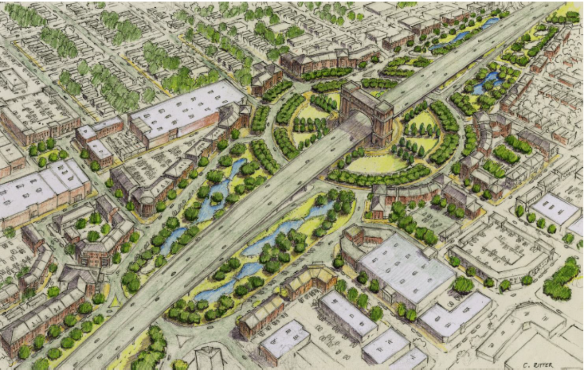
The Connector Design Team responded by opening up the process to allow for “refinements” to the design for the core segment; this produced a total of 19 concept refinement proposals utilizing 6 concepts. It was here that the ETRT and ECI attempted to intervene with their ideas for better neighborhood connectivity and compatibility with “New Urbanism” techniques of broadening mixed use development. In early August, DOTD announced that they would reduce the level of alternative concepts for their Tier 2 series of detailed analysis down to two: the Elevated Mainline (Series 4) and the Semi-Depressed Mainline (Series 6). This was also in sync with the ECI pushing out their own proposed concepts based on those two alternatives. For posterity’s sake, here are the two ECI options for the downtown core of Lafayette. (From the ECI’s September 27th Charrette Report)

The hope for the ECI was that initial testing did show their Partially Depressed and Covered Mainline to be marginally feasible, and the possibility of huge economic development gains from exploiting the space over the freeway would justify the higher costs as compared to the Elevated Mainline option.

Unfortunately, it appears that those hopes have been dashed to pieces upon further analysis by DOTD engineers.

For the last 2 months, DOTD and the Connector Design Team basically reworked and tested the Elevated, Partially Depressed/Open Trench and Cut-and-Cover designs, eventually resulting in 4 final proposed design options that were presented this week. Let’s go through each one individually:

———————————————————————————–

1) Concept 4-1: Elevated Mainline with Evangeline Thruway Couplet

There are some aspects where the Design Team did incorporate some elements desired by the ECI “TIGER Team”; they “flattened” the mainline in the area between Second Street and Taft Street so that it paralleled Chestnut Street and the Burlington Northern Santa Fe Railway (BNSF RR) line; and they did do away with the original plan of a loop ramp at Taft Street for connecting the Thruway to the southbound Connector mainline in favor of a more traditional slip ramp pair to the Thruway at Eleventh Street. In addition, the Elevated Mainline would assume a taller structure for the viaduct; only thing left to be determined would be whether a 22′ or 30′ vertical clearance would be utilized.

In Concept 4-1, the Evangeline Thruway stays mostly in its existing one-way couplet up to just past Jefferson Boulevard, where it transitions into boulevard-like facility centered on the southbound Thruway roadway, to get away from the Sterling Grove Historical District and the St. Genivieve Catholic Church. It then gets incorporated into the freeway frontage road system, but with the northbound Thruway roadway rebuilt on new alignment parallel to the mainline; the former northbound roadway would be transformed into a local two-way street (Cigg Street before the Thruway was built, maybe??)

Cross section profile for Elevated Mainline

The existing profile for the Elevated concepts allows for a 22 foot vertical clearance under the structure in order to reduce the visual impact to surrounding areas; however, there is an option to even further increase the height to allow for a 30′ clearance, which could possibly raise the height of the freeway to as much as 45′ above ground level.

I-49 Connector Elevated Profile Heights above current
ground level, reflecting both 22 foot & 30 foot verticals
Another interesting adjustment is that Simcoe Street is essentially severed across the freeway mainline in order to free up more space for mitigating the visual impact on the St. Genevieve Church property. On the west side, Simcoe traffic would be diverted to Chestnut Street and then the Second/Third one-way couplet, which would then tie back into Simcoe on the east side. There would be also a new connection on the west side using the old Dudley Avenue right-of-way to connect with Greig Street. (Dudley Ave. was absorbed by the southbound Thruway when the latter was built.)
Section of I-49 Connector Elevated Option near Sterling Grove
Historical District (Concept 4-1, with One-Way Couplet)
Also noted is that Mudd Avenue, which traverses the Sterling Grove District, is severed between the former northbound roadway/future local street and the rebuilt northbound Thruway frontage road. This is apparently to remove direct heavy traffic access from Mudd eastbound, and to further provide a continuous buffer for homes in Sterling Grove and the St. Genevieve church/school property. Mudd would still have full access to the Thruway frontage system, though, because it would pass underneath the freeway mainline to connect with the northbound roadway. 
Treatment of Mudd Avenue intersecton with
realigned Evangeline Thruway frontage system
under both Elevated concepts (severage between
new northbound Thruway and former northbound
Thruway roadway converted to local street)
The proposals from the Evangeline Corridor Initiative studying means to retain connectivity throughout the Connector freeway corridor originally recommended Mudd Avenue be retained as a continuous arterial across the freeway/frontage system, but with the portion crossing the Sterling Grove Historical District converted into a “Complete Streets” multimodal facility more friendly to bicycle and pedestrian traffic. Both Concept 4 plans differ in that they would sever Mudd between the new northbound frontage road and the former northbound Thruway roadway, which would be converted back to a local two-way street. Negotiations with Sterling Grove residents and further feedback could get that connection restored during the latter stages of Tier III analysis.
Essentially, this is Concept 4A from the Tier 1 studies, with some minor tweaking. Other than the changes around Sterling Grove and St. Genevieve, and the addition of the elevated portion shadowing Chestnut Street, it’s pretty much status quo.

———————————————————————————-

2) Concept 4-2:  Elevated Mainline with Evangeline “Grand Boulevard”

This concept is basically the same as 4-1 but with one important exception: the Evangeline Thruway one-way couplet is replaced with a tighter “urban boulevard” taking up the southbound roadway’s ROW and just to its west. The northbound Thruway in its entirity is downgraded to a two-way local street. (Clay & Magnolia Streets used this ROW before they were taken by the Thruway.) The complimentary Tier 1 proposed refinement concept was Concept 4D.

Original Refinement Concept 4D, which served as the
genesis for Concept 4-2

The freeway would be pretty much offset by one block in the downtown core area from the Thruway frontage system (whether a couplet or a boulevard); and, as I said, Chestnut Street would remain open but would be shadowed by the open freeway structure. Full access underneath the freeway would be retained. The same option for higher vertical clearance (30′ instead of 22′) would exist for Concept 4-2 as it would for 4-1, as would the same revisions for access for Sterling Grove.

Section of I-49 Connector Elevated Option near Sterling Grove
Historical District (Concept 4-2, with Boulevard)


—————————————————————————–

3) Concept 6-1: Semi-Depressed Mainline with Open Trench

This proposal is an improvement on Concept 6A in the Tier 1 study, with refinements and adjustments developed through feedback with the Evangeline Corridor Initiative group. Its main feature consists of dropping the Connector freeway mainline 10 to 12 feet below ground level, while also allowing an additional 10-12′ of vertical clearance space above ground level. This would meet the DOTD standards for 20′ of vertical space for freeway vehicles. Important cross streets would be elevated over the freeway via bridge structures.

Original Refinement Concept 6A (Semi-Depressed with
Open Trench); the genesis for Tier 2 Option 6-1

One interesting variation that was added since Tier 1 was the realignment of the southbound Evangeline Thruway roadway south of Johnston Street to pass over the mainline before Taft Street in order to align itself correctly with the southbound frontage road near Pinhook Road. This realignment requires a similar realignment of Taft Street to pass over the freeway, shifting its connection with the northbound Thruway roadway from Fourteenth Street to Thirteenth Street. Also, Fifteenth and Sixteenth Street would be severed at the Thruway to allow for the south connection ramps to slope properly.

Profile of Semi-Depressed Open Trench structure

The same evolution of the Thruway into a semi-boulevard from Jefferson to Simcoe, then to a parallel frontage road system north of there, would exist as with the Elevated option. However, the access for the Sterling Grove and Ballard Addition neighborhoods would be radically different with the Partially Depressed option due to the needed transition of the mainline from depressed to elevated to cross the Louisiana & Delta Railroad (L&D RR) spur line. Mudd Avenue would have to be completely severed across the freeway, and would be connected only with the frontage roads with no access between them. Chestnut Street would be totally wiped out, of course; so access for Simcoe would have to be switched to North Grant Street to access Second Street to cross the freeway and get to the east side. (Second and Third Streets would become autonomous two-way streets rather than a one-way couplet in this option.) Simcoe on its eastern flank would be diverted into the Dudley Avenue ROW and then turned back onto Greig Street with no connection at all to the southbound frontage road. Bellot and Tissington Streets would be the only means of cross-street access north of Second Street for Sterling Grove and Ballard Addition up to the L&D RR crossing.

Closeup view of cross-street access changes near
Sterling Grove Historic District from
Concept 6-1 (Semi-Depressed Open Trench)

But the rubber starts to really hit the road with the Semi-Depressed option (and Cut-and-Cover option as well….more on that later) with the downtown major cross street crossings and how they cross the BNSF railroad. The original Concept 6A proposal had Jefferson, Sixth, and Johnston Streets all grade separated over both the freeway and the rail line. That created some issues with the cross street railroad bridges extending past Cypress Street on the west side and disabling it as an access street; as well as issues with Johnston Street’s intersection with Cypress Street and Garfield Street, which sets the boundary for the Freetown-Port Rico neighborhood. That’s a major issue, considering that F-PR was recently made an Historical District with all the protections included.

Original concept for Tier I Enhancement Option 6A
(Semi-Depressed Mainline) showing grade-separated
overpasses of BNSF RR at Jefferson, Third, &
Johnston streets

The original 6A, as seen in the above graphic, used the original curvature of the 2003 ROD Selected Alternative, bringing the freeway close to the BNSF rail line near Johnston Street. The ECI folks, in their Charrette presentations, proposed the idea that if the curvature of the freeway mainline was “flattened” to push the apex of freeway curvature 150 feet eastbound away from the railroad, there would be enough space that the cross streets would return to ground level to cross the rail line at grade. The general idea for the ECI proposal was to have 50-100 feet of slope on either side of a 150′ mainline ROW, raised 18′ above ground level, and returning to existing level before the rail line to the west and the existing southbound Evangeline Thruway to the east. (More on why that idea fell apart for the Surface Tunnel option later on.) The original ECI Covered Mainline proposal for the downtown segment is illustrated below:

Evangeline Corridor Initiative’s original concept
for Semi-Depressed/Cut-and-Cover “Surface Tunnel”;
including “flattening the curve” of mainline
& shifting Evangeline Thruway frontage roads
to directly above/flanking covered freeway (from 10-27-16
Charrette Report)

DOTD and the Design Team, upon further study, found and reported that the concept of returning the cross streets to existing grade at the BNSF RR crossings would marginally work with the crossings at Second, Third, Jefferson, and Sixth streets. While those roadways could be returned to ground level in time to cross the BNSF/UP railroad at grade, there would be some issues with the slope of grade (nearly 7%) approaching the railroad crossings, especially for high profile vehicles. It was, though, technically feasible. Note that this option replaces the existing Jefferson Street underpass of the BNSF rail line with an at-grade crossing….for obvious reasons.

Overview of proposed Semi-Depressed overpasses of
Second, Third, Jefferson, and Sixth streets; with return
to level-grade BNSF RR crossings
Profile of Semi-Depressed option overpass of Third Street
(would also apply to Second, Jefferson, and Sixth)
Semi-Depressed (Open Trench)
cross street gradient profiles for
Downtown section
Such was not the case, unfortunately, for the Johnston Street crossing. The studies found that there simply wasn’t enough space between the depressed freeway ROW and the railroad to allow for a safe return to grade to provide a grade level crossing. 
Original profile of Johnston Street overpass of Semi-Depressed
option returning to level grade to cross BNSF RR (rejected
due to insufficient space)

Thusly, the only alternative for Johnston Street was to elevate it in order to cross over the railroad. And that’s where everything starts to fall apart. For starters, the required 23.5′ clearance over the BNSF rail line would be much higher than the clearance needed over the Semi-Depressed freeway ROW. Most important, though, is that the overpass would require an excessively steep gradient to the west of the railroad if the idea was to return Johnston to grade near the Cypress Street/Garfield Street intersection. That was important because Johnston runs right through the Freetown-Port Rico neighborhood, which was recently endowed with Historical District status, giving it special protection against any intrusion upon it. Johnston Street is also the main arterial to the campus of University of Louisiana at Lafayette, and ultimately serves as the hurricane evacuation route for Vermilion Parish. You really don’t want hurricane evacuation traffic having to traverse a 9% grade.

Original Johnston St. BNSF RR overpass profile with Semi-
Depressed option to avoid penetrating Freetown-Port Rico
Historic Distric
t

An alternative that was proposed to mitigate that situation was to raise Johnston Street and extend the structure to meet level grade at Vermilion Street to produce an acceptable gradient of 4%. That would not only require elevating the Garfield Street intersection nearly 12′ above ground and severing Cypress Street; but also elevating Lincoln Street’s intersection as well. The resulting penetration using Johnston Street would be a serious encroachment of the Freetown-Port Rico Historical District, bringing the full wrath of Section 4(f) and Section 106 violations. Nevertheless, the proposal here does include the elevated and separated Johnston Street overpass with the extended gradient.

Johnston St. profile for Semi-Depressed option
revised for sufficient gradient profile; note serious penetration
of FTPRHD due to need to elevate Garfield & Lincoln
streets.

Vertical view of intrusion of revised Johnston
St./BNSF RR overpass for Semi-Depressed
Open Trench option into Freetown-Port Rico
Historic District

You can notice also how the intersection of Johnston Street and the southbound Evangeline Thruway/frontage road has to be elevated on fill to meet the profile of the railroad overpass.

The Semi-Depressed alternative would also have some very severe ramifications for the neighborhoods surrounding the Sterling Grove Historical District as well. While the SGHD would not be impacted directly with any ROW takings with this or any other of the proposed concepts (same with the original 2003 ROD Selected Alternative), there would be some very nasty indirect impacts.

For starters, the Evangeline Thruway between the L&D RR rail spur crossing and Jefferson Street would have to be totally rebuilt and raised on either fill or structure to adapt to the standard vertical clearances required for the 10′ depressed mainline. This would mean the Thruway and cross streets would have to be raised as much as 8 to 10 feet, and the actual crossing of the mainline would require as much as a 19 foot vertical clearance. While the northbound Thruway roadway would be shifted westward further away from the SGHD (and especially Saint Genevieve Catholic Church and School, which directly fronts the original northbound Thruway roadway), the raised height would still introduce at least a strong visual impact.

Semi-Depressed Open Trench cross street
access changes for Sterling Grove/Simcoe/
Second/Third/Jefferson area
Roadway vertical profile heights for Semi-Depressed
Open Trench option (values are above ground level)
Profile gradients of cross streets & frontage system for
Semi-Depressed Open Trench option
Then, there is the severing of Mudd Avenue at its intersection with the Thruway frontage roads. Due to the need to elevate the southbound roadway to cross over the mainline, Mudd on the west side is “teed” (terminated at a T intersection) at the southbound Thruway, while its east side going through the SGHD is similarly “teed” with the realigned northbound Thruway frontage road. No access across the freeway is possible there due to the vertical clearance requirements for the mainline. Considering that Mudd Avenue is an important arterial that also carries US 90 off of the Thruway, that’s an important issue. 

Severage of Mudd Avenue due to Semi-Depressed Open Trench
option

The local cross streets from Goldman to Tissington up to the rail spur are kept open underneath the mainline (where it transitions to an elevated facility to cross the rail spur) to allow for cross access. The elevation of so many cross streets would require far more displacements and loss of access for residents, causing much more disruption for those neighborhoods.

The same would also go for the segment near Taft/Fourteenth streets, because of the realignment of Taft Street to connect with Thirteenth rather than Fourteenth, and the subsequent severing of Fourteenth, Fifteenth, and Sixteenth streets to accomodate the south connection ramps and the raised grades for the southbound roadway to pass over the mainline and connect with Taft.

Treatment of cross street access with
Semi-Depressed Open Trench option
near Taft St./Pinhook Rd. area

——————————————————————————–

4) Concept 6-2: Semi-Depressed “Cut-and-Cover” Mainline

This concept originally evolved out of Concept 6E of the earlier Design Team Concept Refinements. The original thought was that perhaps if both the railroad and the freeway mainline were shifted east a bit, the overpasses would remove the impact of at-grade rail crossings. One look at the implications of derailments of the railroad within the tunnel, as well as the impacts to access downtown, was enough to render that concept as impractical.

Original Refinement Concept 6E, which served as the foundation
for both the ECI Semi-Depressed Covered Mainline proposal
and the ultimate Tier II Concept 6-2 “Cut-and-Cover” option

However…..the Evangeline Corridor Initiative group (aka the “TIGER Team” due to the Department of Transportation grant it was bestowed upon to study integrating the Connector freeway into the community better) seized upon the burnt ashes of Concept 6E to develop their own alternative which they though could serve the same goals better. The resulting “Surface Tunnel” proposal eliminated the overpasses altogether and pushed the railroad centerline back to its existing ROW, creating enough space between the freeway ROW and the railroad to allow all the cross streets to return to grade.

Evangeline Corridor Initiative’s “Partially Depressed
and Covered Mainline” proposal

It certainly looked more than good on graphics, and it was enough for LADOTD to allow that concept to get more detailed vetting in the Tier II process. Unfortunately, the same problems and issues that affect the Semi-Depressed open trench also dissuade the Cut-and-Cover option as well…and then some.

It should be noted that the ECI propsal extended the capped/tunneled section north to include a total reconnection of Mudd Avenue, and allowed for the extension of some more local streets between Johnston and Taft streets for better connectivity. Apparently, DOTD found those to be impractical, because they don’t make their final Cut-and-Cover proposal. The cap remains set between Second Street and Taft Street, with the remainder of the mainline open-trenched.

Profile of Cut-and-Cover Tunnel structure

The same issues involving the downtown cross-street crossings with the Semi-Depressed open trench also exist with the Cut-and-Cover tunnel…but with the additional need of even higher vertical clearances to accommodate the cap. The result for the minor cross streets (Second, Third, Jefferson, Sixth, and Taft) is an even steeper gradient required to return the streets to grade to cross the BNSF/UP line. Even with that, the gradients are still marginally feasible (although, according to LADOTD, “not desirable”). Note also that, as with the Semi-Depressed open trench, the existing Jefferson Street underpass of the BNSF RR is removed and replaced with an at-grade crossing.

Downtown cross street gradients for
Cut-and-Cover option

Vertical profile for Cut-and-Cover Third St. Overpass
(applicable to Second, Jefferson, and Sixth streets as well)

Notice also that unlike the ECI Covered Mainline option where the cap returned to existing grade before the existing southbound Evangeline Thruway, this Cut-and-Cover option massively expands the embankment eastward to the point that the Thruway frontage roads have to be raised nearly 16 feet and straddled to meet the desired sloping profile. The ECI’s proposal for their Semi-Depressed Covered Mainline was to reduce the embankment on the east side that it would return to existing level grade before the southbound Evangeline Thruway, similar to the sloping on the westbound side. Apparently, that was rejected by the LADOTD engineers as too excessive a slope; instead, the embankment extends all the way to the existing northbound Thruway roadway ROW, and even takes on area east of the Thruway between Third and Simcoe streets.

Profile of proposed Cut-and-Cover Johnston St. overpass
(showing insufficient space for return to existing grade level
for at-grade BNSF RR crossing)

The same issues that befell the Semi-Depressed Open Trench option also exist here with the Johnston Street crossing; to which the same solution of an expanded railroad overpass penetrating the Freetown-Port Rico Historic District is offered.

Proposed Cut-and-Cover Johnston St./BNSF RR overpass
based on avoiding FTPRHD penetration
(rejected due to excessively steep gradient)
Revised Cut-and-Cover Johnston St./BNSF RR overpass
adjusted for sufficient gradient
(with penetration of FTPRHD)
Overview of proposed Cut-and-Cover Johnston St./BNSF RR
overpass showing penetration of FTPRHD
The resulting gradients and roadway heights:

Summary of the cross street/frontage system gradient profile
for the Cut-and-Cover concept
Summary of profile heights of roadways/embankment above
ground level for Cut-and-Cover option

And also….the same issues with cross access for Sterling Grove exist as with the Semi-Depressed option, with the same resolutions therein.

Treatment of cross street access for Cut-and-Cover option
near Mudd Avenue/Sterling Grove/Second/Third/Jefferson
(virtually same as Semi-Depressed Open Trench)

Those issues alone would be enough to dissuade the Cut-and-Cover option….but apparently that wasn’t enough for LADOTD. The Tier II Technical Memo report also gives some clear and concise detail of the potential downsides of constructing and operating the surface tunnel, as well as the high costs of maintenance and operation. There would have to be additional considerations for ventilation and egress of trapped vehicles in the event of an incident inside the tunnel. Fire suppression, lighting, and drainage would also have to be dealt with, especially in the event of a major hurricane evacuation through Lafayette. Also, due to Louisiana state law, handlers of hazardous materials would not be allowed to use the tunnel; they would be rerouted through the surface frontage road system.

———————————————————————————-

Conclusion: Comparing The Tier II Alternatives

All of this leads to the ultimate comparison: How do they stack up? The following two tables tells the tale.

First, the displacements and ROW that would be needed:

Displacement and ROW acquisition matrix for all Tier II concepts

As plainly seen, the two Concept 4 options would require less ROW than even Concept 1A (the original 2003 ROD Selected Alternative) due to the elimination of the two direct interchanges, and would have fewer displacements as well. 4-2 (with the boulevard) would use up slightly more takings than 4-1 (the couplet). The Semi-Depressed option (Concept 6-1) would be slightly worse than Concept 1A overall. The Cut-and-Cover option (Concept 6-2), though? Off the charts, with nearly three times the displacements and ROW needed due to the expanse of the embankment needed to cap the tunnel.

Even worse for the Cut-and-Cover option is that LADOTD could only acquire and pay for ROW for those areas used for “transportation purposes”, meaning that other funding sources would have to be located for any property takings outside of the immediate ROW. That would add an additional expense for LCG outside of its otherwise full commitments.

Matrix of 4(f) and Section 106 impact
to Freetown-Port Rico and Sterling Grove Historical Districts
for all Tier II Concept proposals

This is the preliminary impact matrix to the two Historical Districts that the Connector passes near. An Memorandum of Agreement (MOA) is already binding on all parties regarding mitigation for the visual impacts of Sterling Grove Historic District of the originally approved Concept 1A/2003 ROD alternative. More than likely, that MOA will be extended and modified to fit the needs for the new alternative concepts.

It’s likely that the impact will remain the same or even be sightly reduced with the two Concept 4 options, since the shift of the northbound roadway and the adjustments to the northbound connection ramps, combined with the removal of Simcoe Street, do lessen the impact to Sterling Grove greatly. Freetown-Port Rico would not be significantly affected either by the Elevated Option, save for a possible visual impact due to the height of the viaduct, especially if the higher 30′ vertical clearance is chosen.

By contrast, Concepts 6-1 and 6-2 would both require the penetration of the Johnston Street overpass over the freeway and BNSF railroad — a major penetration into the FTPRHD which would probably trigger Section 4(f) protocols for avoidance of impacts to historic properties.

Now, we get to the most important consideration: the cost.

Matrix for comparison of planning level costs for all Tier II Concept alternatives

Keep in mind that these cost estimates are only for the core section between the L&D rail spur and Pinhook Road, not for the entirity of the Connector freeway.

Finally, LADOTD made a comparison matrix rating all the Concepts they studied based on specified criteria. The results are shown below:

LADOTD Comparison Matrix for all Tier II Conceptual Alternatives

As plainly seen, the Concept 4 alternatives, due to their elevated nature, scored higher on the favorability index than the original Concept 1A/2003 ROD Selected Alternative; and both were far higher ranked than the Concept 6 alternatives. Concept 6-2 (the Cut-and-Cover concept) was universally panned for its excessive up-front costs, its high maintenance, its incompatibility with the goals of hurricane evacuation and Haz-Mat material transport, and its excessive taking of ROW and displacements as compared to the Concept 4 (Elevated) concept alternatives. Concept 6-1 (the Semi-Depressed Open Trench option) scored only less slightly worse than the Cut-and-Cover, but still got plenty of red and yellow marks.

Some advocates for the Cut-and-Cover point to the fact that while the front end costs for that option seem prohibitively expensive, the induced rewards for redeveloping the property taken near the ROW would ultimately make for a better economic return down the line. The ECI did do a study on that, claiming that there would be a $6 million a year local tax base return on overall economic development from the Semi-Depressed Covered Mainline option as opposed to the Elevated Mainline option.

Problem is, though, most people don’t think so long-term, and the sticker shock of $818 million for a 1-1/2 mile tunnel will probably be more than enough for most officials to declare the Cut-and-Cover option to be a good idea that just wasn’t good enough. The Semi-Depressed open trench option might be a bit cheaper, but the image of it becoming a flowing tributary of the Vermilion River after a heavy rainfall event may become etched enough in people’s minds to reject that, too.

Which means that it’s becoming more apparent that we are back where we were at the beginning, with an elevated I-49 Connector freeway going through the heart of Lafayette.

Unless some unforseen new environmental impact (such as the possible contamination of the former Southern Pacific Railroad rail yard, or the resolution of the Connector messing with the flight path of Runway 11-29 at Lafayette Regional Airport) was to emerge, the only remaining obstacle to the Connector’s implementation will be the legal firestorm from those opponents who want to kick this project completely out of Lafayette in favor of their Teche Ridge Bypass through St. Martin Parish. I’m sure that the Concerned Citizens for Good Government and the Greater Acadiana Sierra Club are already calling their lawyers for the inevitable second lawsuit that will be filed the day after the Supplemental ROD is delivered for this current study. We’ll just have to watch this unfold.

Building The Better Mousetrap: ECI, Signature Bridges, And The Surface Cover That Could Change The Game

The most fundamental question involving construction of the I-49 Lafayette Connector from the beginning has been this: Can a major six-lane freeway be built through the heart of Lafayette that can be integrated with the historic neighborhoods and downtown without wiping them off the map?

Many living in those neighborhoods, along with many advocates for New Urbanism, have said, “Oh HELL TO THE NO!!”, citing the history of badly planned and executed freeways being driven through inner cities without any due planning or respect for those being razed. They have been and still are the biggest advocates for swinging I-49 around the city via a bypass, while protecting the inner neighborhoods through “road diets” and reemphasis on non-auto based transportation options.

Thankfully, that attitude is being seriously challenged by a new breed of urban planning that could change the way that urban freeways are built in these areas. And, they just might have more than a snowball’s chance in Hell of executing their designs here in Lafayette.

The Evangeline Corridor Initiative (ECI) is an outgrowth of the Evangeline Thruway Redevelopment Team (ETRT), an organization founded by the Lafayette City/Parish Consolidated Government (LCG) as a go-between for redevelopment of the neighborhoods affected by the Connector freeway. The ETRT was formed under the guise of a joint agreement between LCG and the Louisiana Department of Transportation and Development (LADOTD or DOTD) to enact preliminary corridor preservation and property acquisition for the Connector project. It’s main focus, however, is to attempt to successfully integrate the Connector project with the surrounding neighborhoods and downtown in a seamless and constructive fashion that promotes both Smart Growth principles and appropriate development.

In 2014, the ETRT applied for and was awarded a $500,000 grant from the US Department of Transportation through its Transportation Investment Generating Economic Recovery (TIGER) Grant program for implementing and integrating the Connector freeway project with the community of Lafayette that would be most impacted by its construction. Their now ongoing study has the goal of not only meshing the freeway with its surroundings, but also provide more direct connectivity between the neighborhoods affected through more diverse options for transport (such as bicycles and walking); as well as improve opportunities for more suitable and better scaled economic development.

To facilitate the implementation of the project, three Areas of Influence were established for the Connector freeway:

— Area  Level I consisted of the actual right-of-way taken for the freeway facility;

— Area Level II consisted of a 500 foot buffer zone on either side of the ROW, which would serve as a transition zone between the freeway and its surrounding neighborhoods; and

— Area Level III consisted of the boundaries of the neighborhoods immediately impacted by the project.

ETRT’s and ECI’s main purpose would be to develop Area Levels II and III, and interact with DOTD and FHWA on refining Area Level I to meet their goals.

When the ECI originally announced its initial study, the assumption was that the design for the Connector would strictly follow the Selected Alternative that was approved in the 2003 Record of Decision. That alternative consisted of a mostly elevated freeway utilizing most of the Evangeline Thruway corridor, save for a segment near downtown where it would follow a gradual curve just east of the Burlington Northern Santa Fe/Union Pacific (BNSF/UP) main railroad line. Two standalone interchanges along that section with a realigned Second Street/Third Street couplet and Johnston Street would provide direct access to downtown and the neighborhoods surrounding that area; grade separated underpasses of the railroad line would prevent conflicts. Other than a brief section between Jefferson Street and Johnston Street where the mainline freeway would be elevated on embankment to account for the ramps to the two close interchanges, the mainline would be elevated for most of its entirity. Higher than usual vertical clearances (22 feet rather than the typical 16.5 feet) would be used in the segment between the Louisiana and Delta Railroad (L&DRR) spur line and Simcoe Street as part of mitigation for the visual impact to the Sterling Grove Historic District neighborhood. Also, the existing Evangeline Thruway couplet would be retained as part of a frontage road system feeding the Connector freeway and providing secondary access along with the interchanges.

Aerial profile of I-49 Lafayette Connector Selected Alternative, based on
2003 Record of Decision and 2007 Conceptual Study

However, when the Conceptual Study was revived in October of 2015, those assumptions quickly were rendered useless. There was the historical strong opposition from those who opposed building the freeway through Lafayette from the very beginning, preferring a bypass alignment to the east such as the Teche Ridge Bypass or the Lafayette Regional eXpressway (LRX) alternative to the west.

However, a different form of opposition soon emerged from downtown interests who did favor the central alignment, but begged to seriously differ on some of its details. The Lafayette Downtown Development Authority (LDDA) was particularly not so keen to some elements of the Selected Alternative; and their objections were reinforced through both the public involvement process of the main Conceptual Design Study and the initial meetings of the Evangeline Corridor Initiative through their innovative “charrette” meetings. The main objections were:

1) The two standalone interchanges with the Connector at Johnston Street and Second/Third Streets took way too much right-of-way that could be used for development, and were unnecessarily divisive for connectivity.

2) The embanked segment of the mainline between Johnston Street and the Jefferson Street underpass was too divisive, and severed an important collector (Sixth Street/Lee Avenue).

3) The Second/Third Street couplet interchange/railroad underpass potentially forced too much traffic onto Congress Street (which the couplet directly fed into), which contradicted plans for remodeling the latter as a “Complete Streets” prototype for pedestrian/bicycle access and slowing vehicle speeds. It also potentially impacted the Coburn Building, an old retail shop that had recently been approved into the National Register of Historic Buildings.

In reaction to those objections, LADOTD was induced to add a six-month period where modifications to the Selected Alternative could be proposed to address these needs. While the alignment remained the same as to not disturb the concept approved by the 2003 ROD, tweaks to the system of access were proposed, ultimately resulting in 19 design “refinement” modifications by May of 2016.

The ECI study was conceived to run parallel with and advise the DOTD study, and to provide some form of feedback for addressing the Joint Use and greenspace requirements for the freeway. Originally, the idea was that ECI would serve only to perform the development of design for Levels II and III…but as the ideas kept rolling in, it was becoming apparent that they should intervene with DOTD to offer up their own alternative designs more suitable to their goals. In the end they settled on two main concepts, both based on concepts developed by DOTD, but with their own alterations.

Elevated Mainline with Signature Bridge

Overview of Elevated Mainline with Signature Bridge
concept from Evangeline Corridor Initiative
(from ECI Draft Charette Report)
DOTD Concept 4D (Evangeline Parkway), the genesis of ECI’s
Elevated Mainline with Signature Bridge design


Generally based on the Series 4 concept from DOTD, this alternative design entailed a continuous elevated structure along the length of I-49 from the Chalmette Drive crossover all the way to the Vermilion River crossing (or even the University Avenue/Surrey Street crossing). The effect would be more of a large scale land bridge crossing Lafayette, with the peak of the crossing designed as a “signature bridge” landmark that would define downtown Lafayette. Instead of direct interchanges downtown, access would be provided through direct connection “slip ramps” to a redefined Evangeline Thruway frontage system, with the slip ramps placed between the L&DRR and Mudd Avenue for north access, and between Pinhook Road and the Vermilion River crossing for south access. The Evangeline Thruway southbound roadway would be reformed as a six-lane urban boulevard for local business development; the northbound Thruway roadway would be downgraded to a two-way local street and returned to the local grid for the McComb-Veazey neighborhood. Accessibility and connectivity would be improved and restored underneath the “signature bridge” by adding additional cross streets over the BNSF/UP railroad, and restoring some one-way streets to two-way for refining the downtown grid. The space immediately under the bridge structure would be developed for public parking and green park space.


Semi-Depressed Mainline with Cover (Surface Tunnel)


This concept was actually not included in the 19 design modifications put out by DOTD, but is a modification by ECI of one that was included. Part of the Series 6 concepts, this was originally developed thanks to input from an unnamed constituent who noted that an original concept of a depressed Connector freeway was vetted and rejected in the early studies. That concept would have depressed the mainline freeway 20 feet below ground level within the median of the the entirity of the Evangeline Thruway. While it was ruled to be marginally feasible, it was rejected out of practicality and the need for I-49 as a hurricane evacuation route. The constituent suggested that maybe a partially depressed freeway would work better; and studies did confirm initially that a 10 foot drop would better allow for gravity drainage.

The Series 6 concept designs are based on dropping the elevated segments from just south of the L&DRR spur overpass to Pinhook Road down 10 feet below ground level, and adding 10 feet of vertical clearance, for a total of 20 feet. Crossing streets would then be allowed to pass over the freeway for connectivity. The first concept (6A) called for an open trench; subsequent concepts added the cover for a partially submerged tunnel effect.

The ECI Covered Semi-Depressed Mainline alternative is an adjustment to LADOTD’s Concept 6E, which originally called for flattening the curve of the mainline freeway and also shifting the alignment of the BNSF/UP rail line 150 feet east of its current ROW and dropping it to the same level as the freeway. All ECI did was to return the rail line back to its current trajectory, but keep the shift of the freeway centerline so that the resulting berming over the freeway tunnel could return to existing grade prior to the rail line. This allowed all the crossing streets to retain at-grade crossings of the railroad, removing the need for overpasses.

The other striking feature of the Semi-Depressed/Covered Mainline alternative is that the Evangeline Thruway is essentially replaced altogether with an avenue/boulevard hybrid built directly on top of the tunneled mainline segment, and accessible through the same “slip ramp” connection system as the Elevated Mainline uses. The original Thruway roadways would be downgraded to local streets within the neighborhood grid. (There is an option that utilizes both the avenue on top and the boulevard on the side.)

Initially, DOTD balked at including ECI’s alterations to their Series 6 options in their initial analysis, citing both the protocol of DOTD handling Area Level I and that the time for entering concept modifications had passed. Under strong pressure from LCG officials insisting that the alterations be added (as a new concept “6F”), DOTD partially relented and allowed for consideration of the ECI alterations to 6E, provided that that series passed the initial Tier I analysis…which it did by August 2016. All of the modifications under Series 4 and 6 are now currently under a more involved Tier II analysis by DOTD, which will result in the culling down to three finalist alternatives by the end of October, and a final selected and approved alternative by the end of December.

Reinventing Lafayette Gateway North…The Arc d’Willow???

Another goal of the ECI study was to find new ways of exploiting the Connector freeway to redevelop neighborhoods that had been struggling to rise economically. The Lafayette North Gateway District is one distinct example. Once a center of activity through Northgate Mall, Albertsons’, and Walmart, North Lafayette along the Evangeline Thruway has suffered greatly economically, and it is accelerated by the lack of through access due to the nature of the at-grade Thruway.

The original concept for the Selected Alternative in this area was to integrate the Evangeline Thruway into the frontage road system as traditional one-way frontage roads, with a slip-ramp diamond interchange at Willow Street and underpass connections at Martin Luther King Drive/Castille Avenue and at Donlon Avenue/Walmart Drive. The Gateway Visitors Center within the median of the Thruway would be removed and relocated to make room for the Willow Street overpass/interchange.

Needless to say, the ECI folks took one look at those plans and announced: “Ummmm…nope. We can do much better than this.” And this was the result:

The second most distinct feature of this refinement is the radical transformation of the Willow Street interchange. No more slip ramp diamond; now it’s a huge circle interchange with the ramps from I-49 connecting directly to the circle rather than the frontage roads. The MLK/Castille and Donlon/Walmart intersections are now smaller circle/roundabouts, too, and all connected with two-way local streets fronting houses and mixed-used development. Both the Northgate Mall and Walmart properties are also transformed into mixed-use/smaller business development as well.

I did say second most distinct, right? For #1, you got to look what’s inside the Willow Street Circle. Behold, behold…the Arc d’ Lafayette!!

Yes, that would be a 60 foot imitation of Paris’ Arc d’Triomphe straddling the Connector overpass of Willow Circle, complete with a new home for the Visitors’ Center and an observation deck on top. This is what you call “thinking outside the box”.

All of this may seem quite expensive and beyond the reach of funding for the Connector freeway, but considering the alternative of not completing I-49 South or having it diverted around Cypress Swamp and St. Martinville and Breaux Bridge for no benefit, I’d say that this deserves more than just a look.