Could The Connector Be Improved? A Few Suggestions

Although the process for the Connector freeway Conceptual Design Study has already produced plenty of suggestions for refinements and alterations, there are a few that may have been missed out on. Here’s some of my own that I think would improve the prospects.

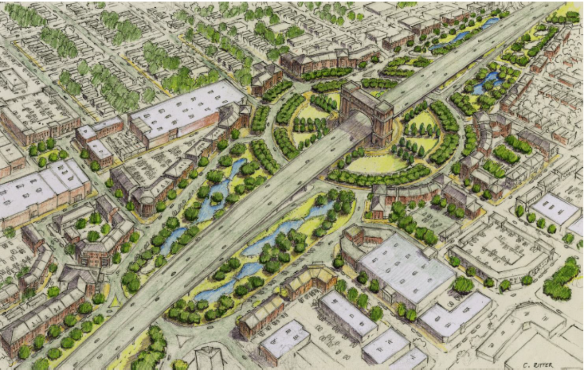
1) Shift the north access ramps from the Evangeline Thruway frontage road system from north of Second Street to north of Mudd Avenue, and retain cross-street access for both Mudd Ave. and Simcoe Street.

The current plans for the “refinements” put forth by the LCP and DOTD drop the north exit/entrance off ramps down between Greig and Second Streets, and block off Simcoe Street altogether in order to create more space for a plaza around St. Genevieve Catholic Church and School. In addition, all the options sever Simcoe St entirely, and partially severs Mudd between the Thruway frontage system and the old northbound Thruway, which is converted into a two-way local street from Greig Street to Bellot Drive.

This has the advantage of offering a buffer zone for the Sterling Grove Historical District, but at the cost of providing vehicle/pedestrian/bicycle access across the freeway. With both Mudd and Simcoe severed, vehicles wishing to cross the freeway to access neighborhoods to the west would have to either use the Second/Third one-way couplet, or use a turnaround that would be provided just before the crossing of the rail spur north of Tissington Street.

It’s understandable why planners want to reduce vehicular access to Sterling Grove, but not at the expense of removing two vital cross-circulation arterials.

Shifting the north access ramps to before Mudd would allow both Mudd and Simcoe to retain their full access, and also allow for a full buffer for Sterling Grove that doesn’t interrupt full vehicular access.

The only drawback in this is that in order to make way for the ramps, all of the local cross streets between Mudd and Bellot Drive would have to be severed (Goldman, Hobson, Sampson); but the old Thruway could handle the transition.

2) Shift the south access ramps, which are currently planned to connect to the Thruway at Eleventh Street, to more traditional “slip ramps” south of Taft Street. 

The current LCP proposal uses traditional ramps to curve to meet the existing Evangeline Thruway couplet at Eleventh Street. These ramps are supposed to also provide the connection between the freeway and Johnston Street/Louisiana Avenue in lieu of a direct interchange.

The problem with this concept is that it conflicts with the desire of city officials to better connect the McComb-Veazey and Freetown-Port Rico neighborhoods. The two areas are separated from each other by the heavy industrialized property now occupied by Conco Distribution Company and the former Southern Pacific Railroad distribution yard property. The Evangeline Thruway Redevelopment Team (ETRT), through its Evangeline Corridor Initiative, had been looking at ways to extend some streets (such as Eleventh or Twelfth Street) across that property in order to connect McC-V and FTFR better; their proposals allow for that by shifting the access ramps between the Connector and the Thruway frontage road system further south to either south of Taft Street or south of Pinhook Road.

The LCP/DOTD Concept 4 proposals, however, nixes that by placing the south connection ramps to meet with the Thruway at its connection with Eleventh Street, essentially blocking any means of connecting McC-V with FTPR other than the existing connections of Taft Street, Pinhook Road, and Louisiana Avenue/Johnston Street. The Concept 6 proposals, if anything, are worse; they shift the Taft Street connection from Fourteenth Street to Thirteenth Street, and they totally wipe out the median of the Evangeline Thruway in order to provide for the grade changes to elevate the southbound frontage road to cross the depressed freeway mainline.

The ECI’s Partially Depressed/Covered option solves that problem by shifting the Thruway from its existing couplet paralleling the freeway to directly over the freeway mainline, which would allow the existing Thruway roadways to be converted to local two-way streets; and also allowing enough of a transition over the embankment to extend some cross streets. Moving the south connection ramps to south of Taft and north of Pinhook allows for that option to work.

The ECI’s Elevated option even shifts the south connection ramps even further south to south of Pinhook Road; but that brings a conflict with the connection to East University Avenue/Surrey Street, which serves Lafayette Regional Airport. (But, more on that later.)

In any case, shifting the south ramps to south of Taft, whatever the final design would be, could for those very reasons open up more and better connections between McComb-Veazey and Freetown-Port Rico.

3) Resolve access to the Sterling Grove Historical District and the abutting neighborhood to its west across the proposed freeway ROW by restoring cross-street access via Mudd Avenue and Simcoe Street.

The main issue here is that in order to protect Sterling Grove and the St. Genevieve Church and School from more direct impacts, LCP’s planners designed to cut access through that neighborhood by severing both Mudd Avenue and Simcoe Street. The Concept 4 alternatives do allow for Mudd to be connected to both the southbound and realigned northbound frontage roadways, but still severs Mudd east of the new northbound roadway. The Concept 6 alternatives completely sever Mudd between the northbound and southbound roadways. In addition, both concepts completely sever Simcoe Street to allow for the north ramp connections to meet the frontage road at Second Street; Simcoe is diverted to the Second/Third one-way couplet and then either to a realigned Chestnut Street (for the elevated Concept 4 alternatives) or to Grant Street (for the depressed Concept 6 alternatives).

Naturally, this creates a major issue for Sterling Grove residents wanting to access the neighborhood on the other side of the Thruway, and vice versa. Obviously, you don’t want to encourage major traffic to blow through Sterling Grove using Mudd Avenue, but Mudd is still a significant collector arterial both west and east; and Simcoe is the principal connector between Sterling Grove and another historical neighborhood, Parkside.

Solution 1) as defined above (shifting the north connection ramps to north of Mudd Avenue) would do plenty to resolve the situation, since that would allow for retaining both Mudd and Simcoe as cross connections. Alongside that, the potential issue of Mudd Avenue becoming a convenient speed magnet through Sterling Grove can be resolved through two means: remaking Mudd from the Thruway to Louisiana Avenue into a Complete Streets corridor, and building a roundabout between Mudd and the former southbound Thruway/future local street.

One other issue is that shifting the connection ramps would cause some of the existing cross streets (Hobson Street, Sampson Street, Goldman Street) to be severed between the frontage road Thruway system (although, the existing former northbound Thruway converted to a local street could still serve as a buffer). The benefits of keeping Simcoe and Mudd open would in my view offset this..and you could keep Bellot Drive and Tissington Street open as cross streets or add some turnarounds to reinforce access.

4) Consider elevating the BNSF/UP railroad line at its current ROW on structure through downtown Lafayette, allowing the cross streets to pass underneath at ground level.

The handling of the BNSF/UP main railroad line through Lafayette has been one of the most contentious issues with the Connector freeway design. The originally approved 2003 FEIS/ROD design had two direct single point diamond interchanges between the freeway and both a merger of the Second Street/Third Street one-way couplet and Johnston Street; with the interchanging cross streets depressed to pass underneath the railroad line. The original Base Case also severed the Sixth Street/Lee Avenue crossing in order to allow room for the ramps to the two downtown interchanges.

This was altered in the Conceptual Alternatives Enhancements revisions to eliminate the direct interchanges altogether, restore the Sixth/Lee crossing, and devise new means of connecting the cross streets through the freeway ROW. Under the Elevated concepts, it’s a simple deal: the cross streets pass underneath the elevated structure at grade level as they do now; with only the option of a depressed underpass at Johnston Street offered to improve access. Under the Partially Depressed and Cut-and-Cover concepts put forth by LCP/LADOTD, it gets a bit more complicated; 2nd/3rd. Jefferson, and Lee/Sixth get at-grade crossings of the railroad, but Johnston gets an overpass that penetrates the Freetown-Port Rico Historical District to such an extent that both the Johnston Street intersections with Garfield Street and Lincoln Street would have to be elevated either on fill or structure.

What all of those proposals share is the common design that the railroad remains at current level in its existing ROW. One design alternative that was rejected as part of the Partially Depressed series would have shifted the railroad ROW about 50 to 100 feet to the west of the current position, then lowered it 10 feet to the same level as the depressed freeway. That proved to be too costly and too destructive, as it would severely affect existing crossings outside of downtown Lafayette.

However, there is one alternative design that has not been considered that really should be: raising the BNSF/UP railroad line on structure throughout the downtown area so that the cross streets can pass underneath at existing ground level. It’s not an unprecedented feat for commercial rail lines to be elevated above ground level and seperated from ground-level traffic; Jackson, Mississippi has a similar system using the Canadian National/Illinois Central rail line, and a similar structure is planned for the BNSF line through Tupelo, Mississippi.

The idea generally is to begin the elevated structure just east of the current North University Avenue underpass, then gradually grade it so that it is elevated at least 15 feet from the St. Antoine Street crossing through the curve at Pierce Street and Mudd Avenue/Cameron Street and Simcoe Street, then reaching its full peak of  20 foot elevation downtown between Jefferson and Johnston Street, with a platform built across from or at the Rosa Parks Transportation Center for the Amtrak terminal there, then gradually lowering it back to grade level near the existing East University Avenue underpass. All the major cross streets from St. Antoine Street to Pinhook Road would remain open to pass underneath the mainline; the connection to the Louisiana and Delta Railroad spur to Breaux Bridge would remain at its existing ground level.

The advantages to raising the railroad would be obvious from a noise and traffic standpoint; but it would be especially beneficial for both Downtown Lafayette and the surrounding neighborhoods because the existing ground level track could still be converted into a passenger-based light-rail system that could potentially be extended through Lafayette.

Raising the railroad would be especially beneficial with the ECI Partially Depressed/Covered Mainline proposal, because with the railroad elevated and the cross streets returning to ground level underneath without the conflicts of safety, the impacts on Freetown-Port Rico would be greatly reduced if not eliminated. Also, the Rosa Parks/Amtrak depot platform could be extended to match the height of the elevated embankment needed to mask the semi-submerged freeway mainline.

An alternative to this would be to realign the BNSF-UP mainline to follow the L&D RR mainline to Breaux Bridge, then utilize the abandoned UP line running along the Teche-Coteau Ridge along LA 31 to reconnect with the mainline near New Iberia; and convert the BNSF mainline between Lafayette and New Iberia to a commuter rail/Amtrak/light rail line. This would create its own issues of noise impacts along the L&D line, as well as cost issues.

5) Consolidate the University/Surrey and Kaliste Saloom Road interchanges into one interchange system, and simplify the ramp exit/entrance system to reduce weaving and flood abatement issues.

The southern terminus of the Connector freeway has its own multiple issues as well. There is the bisecting of the flight path of Runway 11-29 of Lafayette Regional Airport; the crossing of the Vermilion River and its floodplain that has been the source of heavy flooding of late, and there is the expense of the Kaliste Saloom Road interchange that has to cross over the BNSF-UP railroad mainline and Hugh Wallis Road and connect with the frontage road system as well as mainline I-49 to maintain access to LRT and the Episcopal School of Acadiana. There is also the conflict involving the Adrien Vega Acadiana Dodge auto dealership, which is located on the Thruway directly across from LFT.

The illustration above shows the design for that section that was approved in the 2003 FEIS/ROD. Note how the directional ramps for the Kaliste Saloom Road interchange connect with both the frontage roads and the I-49 Connector mainline to/from the north, and also how the southbound frontage road is routed around the rear of the Acadiana Dodge dealership. Note also how the Petroleum Helicopters International training facility right across from the current intersection of US 90 with Kaliste Saloom Road effectively limits any ROW acquisition south of that interchange.

Some modifications in design have been proposed and are under consideration for this segment. Due to new regulations involving building runway extensions in wetlands, the University/Surrey interchange design is being modified so that the existing Runway Protection Zone for LFT’s Runway 11-29 will be retained and no extension required. This would entail the possibility of having University/Surrey passing over a depressed I-49 mainline, or depressing University/Surrey to the point that the I-49 overpass doesn’t invade the current RPZ. As for Acadiana Dodge, an alternative design is being offered that shifts the southbound frontage road to a more conventional frontage road format in front of the facility. Minor refinements to the access road connecting Hugh Wallis Road to Kaliste Saloom Road in order to adjust for a new hotel that was built in the original ROW as well as access to the ESA are also being considered.

Further complicating matters are the proposals of the ECI for redeveloping the Vermilion River basin (which includes Beaver Park, Heymann Park, and Vermilionville) as a major recreation area. Their ideas include elevating the mainline to allow for direct vehicular and pedestrian access to connect the park areas now severed by the Thruway; incorporating the former Trappey’s plant on the west side near Beaver Park into the new recreational facility, and building a “Riverwalk” facility connecting the two park areas together.

The proximity of interchange ramps between the Kaliste Saloom and University/Surrey interchanges also may become an issue with interchange spacing, especially since they may also conflict with any possible shift of the south connection ramps to the Evangeline Thruway for downtown to south of Taft Street.

I would think that the ramp system could be greatly simplified by eliminating and consolidating some ramp access between Pinhook Road and south of Kaliste Saloom Road. I’d place the south ramp connection just south of Taft Street; add a ramp connection to University/Surrey just south of the Vermilion River crossing, eliminate the direct ramps to the I-49 mainline to Kaliste Saloom to/from the north, and combine University/Surrey and Kaliste Saloom into one interchange system connection.

It could also be considered to reduce and eliminate the directional interchange at Kaliste Saloom in favor of an elevated tight diamond/frontage road connection where Kaliste Saloom and the frontage roads would have an elevated connection so that the former could cross over the railroad and Hugh Wallis Road on structure. A similar design is being planned for the downstream interchange of US 90/Future I-49 South with Verot School Road.  The main issue, though, would be providing access to the PHI facility on the opposite side, and perhaps some additional ROW requirements.

That’s only a sample of my own suggestions; feel free to add your own. As long as they don’t involve Teche Ridge or downgrading to a boulevard…that’s still a non-starter with me.

How LADOTD Arrogance And Ramrodding The Elevated Option Could Kill The Connector Freeway Project

I just recently read this morning’s article from the Lafayette Advertiser by Claire Taylor over the ruckus that took place yesterday at the latest I-49 Connector Community Work Group meeting…and it has me fuming.

It is getting more and more obvious that the LADOTD, through their consultant group Lafayette Connector Partners, is insistent on ramming a bare bones Elevated Option freeway down the collective throats of Lafayette citizens, with little if any concern or respect for those citizens who would be affected, or those who actually want to make the Connector freeway work the best for Lafayette.

Ms. Taylor’s article documents the tense and often heated arguments that took place between LADOTD Project Manager Tim Nickel and some members of the CWG, concerning questions they had about the Tier II analysis of the four alternatives put forth.  In the end, Nickel ignored their questions, finished the presentation over their heads, and abruptly dismissed the meeting, leaving many members in shock.

More from Ms. Taylor’s article:

When Interstate 49 [C]onnector committee members asked questions and voiced concerns Thursday about the planning  process and level of public input, the state highway department’s project manager ignored their questions and adjourned the meeting.

Tim Nickel with the Louisiana Department of Transportation and Development appeared to become frustrated with questions by members of the I-49 Lafayette community working group. As committee members asked questions near the end of a two-hour meeting, Nickel returned to a PowerPoint presentation, speaking over over their questions, then abruptly adjourned the meeting.

“We’re citizens who were invited to attend and participate, and DOTD shut us down with questions still to be asked,” CWG committee member John Arceneaux said afterwards.

Margaret Trahan, executive director of United Way of Acadiana and a CWG member, added, “Tonight’s meeting was very frustrating. I’m not leaving with a clear understanding of why I’m here.”

The main frustration that the CWG members had was with the analysis of the Concept 6 series of alternatives, in particular the Concept 6-2 “Cut-and-Cover” alternative that called for a full 1-1/2 mile covered tunnel with jet engine ventilation. That alternative was vetted to be the most expensive for the downtown section between Pinhook Road and the Louisiana & Delta Railroad spur crossing, at more than $800 million dollars. By contrast, the Series 4 Elevated Options, which call for an continuously elevated freeway throughout the corridor, was vetted to cost less than $430-450 million dollars….but that did not include any consideration of a “signature bridge” or alterations for neighborhood connectivity or pedestrian/bicycle accessability.

The meeting also exposed the conflict between the LCP team authorized by LADOTD to design the project and the Evangeline Thruway Redevelopment Team (ETRT), the group empowered by Lafayette City-Parish Consolidated Government to develop means to incorporate the Connector project with all the neighborhoods affected. The ETRT, through their Evangeline Corridor Initiative, had created their own separate design concepts for meeting that need; one each for the two concept design series that had advanced to the Tier II study analysis process. As a result, the ETRT had developed their own Cut-and-Cover proposal that ended up radically different than the Concept 6-2 “Cut-and-Cover” tunnel that was ultimately proposed by LCP/DOTD.

The main frustration from the CWG members was about why LCP didn’t allow for consideration in their cost analysis of the conceptual alternatives for additional funding for the “signature bridge” and other CSS design/connectivity components; and also why ETRT’s partial Cut-and-Cover proposal wasn’t given a better vetting or a chance to be altered.

Nickel’s response was that the LCP and consultant team couldn’t give an answer at that point because the process was still ongoing; and that the decisions would be done in January when final “hybrid” alternatives for the entire corridor would be created for Tier III and Supplemental EIS analysis and final selection.

In an earlier article for the Advertiser, Ms. Taylor summarized the situation nicely:

The tunnel version proposed by ETRT after meeting with residents near the interstate route wasn’t intended to be a 1.5-mile long tunnel, Blanchard said, but a partial cut and cover to reduce noise and provide connectivity. Instead of a cost estimate for a partial cut and cover, consultants provide a price for a 1.5-mile long tunnel with a large embankment and jet engine turbine. It includes all the bells and whistles, he said.

The elevated version is a bare-bones model that doesn’t include the cost of a signature bridge, pedestrian and bike lanes, or improvements along Evangeline Thruway such as a grand boulevard. Blanchard said it was a surprise to the ETRT Nov. 30 when Tim Nickel, project manager with the Louisiana Department of Transportation and Development, said he couldn’t commit to paying for bike and pedestrian paths even if they are inside the project right of way.

The group asked for a more limited cost estimate for the partial cut and cover design that would include less tunnel and less embankment than a large tunnel.

“The concern is the 4 series cost estimates, because they don’t include the cost of components such as the signature bridge, are artificially low, while the costs of 6.2, because they may include all the ‘bells and whistles,’ are artificially high,” Blanchard wrote.

The ETRT, Blanchard said, also raised many questions about the signature bridge, which has substantial community support but was not included in the four designs the consulting team advanced in the planning process.

Nickel also, as did his predecessor Toby Picard, dismissed a bit causticly the ETRT’s role in analysis of the conceptual alternatives, stating that they weren’t “an equal partner” in the consideration for a final Connector freeway alternative. Never mind that the ETRT is fully empowered by the original Joint Collective Agreement signed by LADOTD, FHWA, and LCG to provide direct feedback on the project’s impacts on the abutting neighborhoods.

When ETRT member Kevin Blanchard asked Nickel if he would commit to saying that the Series 6 alternatives — especially the Cut-and-Cover alternative — would be allowed to be altered by ETRT or would be eliminated in favor of the Elevated Series 4 concepts, Nickel was noncommited, saying that that decision would be reached by then.

CWG members also expressed frustration with the limited public feedback allowed at their meetings; public comment was limited to only notes on cards, with no time given for verbal discussion. In addition, the membership of the CWG has significantly dwindled down from its initial 60 members down to around 11, and most feedback from the Open House Meeting was limited to comments from other committee members or submitted from attendees at that meeting.

The only compromise that Nickel would give to the ETRT was to allow their objections to be put in the public record at the meeting; but there was no commitment by him to even discuss any of their concerns.

And, it’s not the first time that the LCP has been frosty to the ETRT; when the ECI originally introduced their alternate concepts for the freeway back in August, then Project Manager Toby Picard dismissed them as irrelevant to the process. After an uproar by Lafayette Parish Govermment Councilman Bruce Conque, Picard backed off and reluctantly allowed the ETRT/ECI alternatives into consideration.

But, it appears that LADOTD is still under the impression that only the cheapest, bare bones Connector project will be able to get funding in these austere fiscal days, and that they are driven to push the Elevated option down the throats of Lafayette without any consideration for what may be better.

This is playing with fire, because if LADOTD can’t handle the friendly criticism and analysis of those who do want the Connector built but done right for the citizens of Lafayette, then how will they react when the community revolts in opposition and joins the Teche Ridge Bypass lobby with their ultimate lawsuits and obstruction? The resulting delays could potentially kill not just the best chance to build I-49 through Lafayette, but possibly kill the entire I-49 South extension to New Orleans.

DOTD really needs to take heed and listen to the people for a change before they lose everything.

The Battle Of “The Covers”: ECI’s Partially Depressed Covered vs. LCP’s “Cut-and-Cover”

One interesting byproduct so far of the I-49 Lafayette Connector freeway design process is the emerging differences that are developing between the proposals put forth by the main Lafayette Connector Partners (LCP) design team paid by LADOTD to design the final product, and the Evangeline Thruway Redevelopment Team (ETRT) proposals floated through their Evangeline Corridor Initiative (ECI) process.

As many well know, the ECI was created by the ETRT to satisfy the mandate of the US Department of Transportation TIGER grant they had been awarded back in 2014 to study the best means of integrating the Connector freeway into the broader Lafayette community and better connect the abutting neighborhoods that would be affected by the project. That is a different mandate from the LCP, who is being paid by LADOTD to actually put forth preliminary design and engineering for the project.

It was mainly the ECI and ETRT which had raised concerns about the initially approved design that was vetted through a Record of Decision in 2003; as a result of their concerns, LADOTD was induced to add a series of design modifications and develop alternative concepts for the core downtown segment of the freeway. As a result of the process, four alternative concepts remain for consideration:

— 2 Elevated Freeway options (originally Concept Group 4), one with the Evangeline Thruway remaining as a one-way couplet outside of the freeway ROW (Concept 4-1), the other with the Thruway converted into an urban boulevard (Concept 4-2); and

— 2 Partially Depressed Freeway options (Concept Group 6), one with the freeway depressed on an open trench (Concept 6-1), and the other with the freeway completely capped as a tunnel for 1-1/2 miles (Concept 6-2).

The main issue, however, is that the proposals from LCP are a bit different from what the ECI/ETRT TIGER team has been promoting, and that has caused a bit of concern. Yesterday, Claire Taylor posted an article over at the Lafayette Advertiser detailing the ETRT’s expressed questions for the LCP over their most recent proposals.

The ECI had issued its final and adopted Charrette Report in late October detailing their proposals for neighborhood connectivity alongside the Connector. It appears below (accessible as a Scribd document):

It was right about the same time that the LCP held their second Open House Public Meeting to reveal to the public both the 4 Connector Concept Alternatives and the resolution of Possible Design Modifications (PDM’s) for subsegments of the freeway proposal. A full presentation of both appears below:


This post is to discuss the differences between the official LCP alternatives and those put forth by the ECI, and why they may matter a great deal down the road.

First let’s look at the Elevated options, starting with the LCP Concept 4 alternatives:

Both C4 alternatives utilize an elevated freeway through the core downtown area, and use ramp pairs to the Evangeline Thruway (north connections before Second Street, south connections to the Thruway at Eleventh Street). The difference is that Concept 4-1 retains the existing Evangeline Thruway couplet south of Jefferson Street to near Taft Street; while Concept 4-2 converts that section into an “urban boulevard” running down the southbound Thruway ROW (the existing northbound Thruway roadway south of Simcoe Street is converted back to a two-way local street).

Generally similar is the ECI’s approach to the Elevated Mainline option..but there are some differences.

4

The main major deviation between the C4-2 proposal and the ECI proposal is that with the ECI’s concept, the northern ramp connection with the Connector is pushed back further north to north of Mudd Avenue rather than Second Street; and that both Mudd Avenue is kept open and free flowing underneath the elevated mainline. Under the ECI’s proposal, the south connecting ramps are also shifted further southward to south of Pinhook Road, enabling more connections between Johnston Street/Louisiana Avenue and Taft Street/Fourteenth Street underneath the freeway. This was done to better connect the Freetown-Port Rico and McComb-Veazey neighborhoods. Also notice that like C4-2, the ECI Elevated Mainline proposal assumes a boulevard utilizing the southbound Thruway ROW, and that Simcoe Street is severed and realigned to allow more space at St. Genevieve Church for an open space plaza to mitigate the visual effects.

But those are minor quabbles compared to the differences between the Depressed proposals by both groups. First, the two LCP Concept 6 alternatives:

The main features of the C6 concepts are: 1) depressing the Connector mainline 10 feet below ground level, and adding 10 more feet of vertical clearance above ground level to create 20 feet of vertical clearance; having cross streets pass over the depressed freeway (and, in the case of Johnston Street, over the parallel BNSF/UP rail line as well); 2) elevating and realigning the southbound Evangeline Thruway to allow for raised connections with all the major cross streets; 3) realigning Taft Street to connect with Thirteenth Street rather than Fourteenth Street to better fit the ultimate south ramp connections; and 4) severing both Mudd Avenue and Simcoe Street across the freeway due to insufficient vertical clearance and concern about penetrating the Sterling Grove Historical District. The main difference is that C6-1 uses an open trench for the mainline with bridge structures crossing the freeway; while C6-2 uses an earthen embankment to completely cover the mainline, with a full tunnel structure directly underneath.

That is a significant radical difference from the Partially Depressed/Covered Mainline proposal originally brought forth by the ECI/ETRT team.

The original concept for the “Cut-and-Cover” proposal from the ECI implied only a limited embankment extending only as far as the southbound Thruway and the railroad, with all cross streets returning to grade to cross the railroad. (That proved to be infeasible for Johnston Street, prompting the LCP proposal to add an railroad overpass at that location.) Their proposal also included the option of realigning the Thruway frontage roads directly on top of or immediately flanking the depressed mainline structure, reverting both original roadways using the current Thruway to local streets. There was also an option for a surface boulevard taking in the southbound Thruway as with the Elevated concepts. In addition, similar to the ECI’s Elevated options, the ramp connections to the Thruway were set to north of Mudd Avenue and south of Taft Street, with both Mudd and Simcoe remaining open and free flowing over the covered freeway. Finally, in lieu of a complete tunnel, there were options for a partially covered or cantilevered mainline to avoid ventilation issues with a closed tunnel.

LCP does give as part of their presentation during the November Open House Public Meeting a decent explanation of why the ECI option for an at-grade Johnston Street crossing of the BNSF railroad is not feasible, and why a crossing that directly penetrated the Freetown – Port Rico Historic District was selected as the most viable option. They are a bit less open, though, on why expanding the depressed option to allow Mudd Avenue and Simcoe Street to cross over was not allowed, as well as why the cross connections between Taft and Johnston were not feasible. My guess is that interchange spacing and possible issues with excessive gradients were the main reasons for rejecting ECI’s approach. There was also the issue of penetrating the FPRHD, although why that wasn’t considered a problem for the Johnston Street crossing would then be a decent question to ask.

This wasn’t the first time that there was conflict between the ETRT and the LCP, either. When the ECI first offered up the Partially Depressed and Elevated options, they got a very chilly reception from then LADOTD Project Manager Toby Picard; he essentially accused ETRT of jumping out of their lane and overstepping their boundaries. Apparently, they were only supposed to act on the connectivity portion for the neighborhoods after LADOTD had selected a final alternative. ETRT, however, is backed in its mandate by Lafayette City-Parish Consolidated Government, which by law is required to approve any design for the Connector freeway under the terms of the Joint Agreement that was signed by all parties as part of the Record of Decision in 2003. (Picard ultimately blinked and allowed ETRT’s concerns to be placed on the record; he then left the project and DOTD entirely, claiming “personal reasons”.)

The Taylor article in the Advertiser quotes an email from ETRT member Kevin Blanchard to the LCP and LADOTD expressing concern that before any options are eliminated, the ECI’s questions about the method to the analysis of the alternatives are answered.

One of their main concerns was the cost projections for the four concept alternatives. The C6-2 “Cut-and-Cover” alternative has far and away the most expense, but that includes both the front end construction costs and the back end operations and maintenance costs of the full tunnel. The Elevated options, though, do not include any consideration for the “Signature Bridge” costs; LCP has said that that would be considered later on in the process. The main fear is that LADOTD might invoke financial concerns to drop many of the ECI’s proposals in order to go along with a basic design for the Elevated options.

Kevin Blanchard, who is on the ETRT team, recently posted an article at the Lafayette Independent where he directly states his concerns to LCP about the process, and calls for not eliminating any options until their questions are answered fully. He also proposes some variations to the Depressed options to remove the need for a full tunnel, and also addresses the Johnston Street overpass issues with Freetown – Port Rico and the BNSF/UP railroad. Another idea floated about is converting Johnston Street into a “Complete Streets” corridor with a reduced design speed, which would allow for a gradient tight enough to reduce the penetration of FPRHD.

In any case, this is an issue that will continue to be hashed out as the Connector design process evolves. Updates as they come in.

Why Looping I-49 Around Lafayette Is Not As Good As It Sounds: A Response To Roger Peak And Y-49

Just as it is becoming more and more clear that an elevated I-49 Connector through Lafayette is the most feasible cost-effective option for building the freeway; it is just as clear that the opposition to this project is as loud as it has been since the concept has been planned.

While most opposition to the Connector is mostly based on sheer NIMBYism of not wanting an elevated structure next to their neighborhood; there are also legitimate concerns about contamination of the Chicot Aquifier, which supplies Lafayette’s drinking water, as well as the costs of constructing the freeway, as opposed to the combination of looping the freeway around Lafayette (most often proposed through the Teche Ridge Bypass alternate through St. Martin Parish, less proposed through the Lafayette Regional Expressway loop to the west around Lafayette’s perimeter). As the process of Conceptual Design and the Supplemental Environmental Impact study proceeds, the opposition to the Connector has become a bit more active in stating their views.

Over at the Sierra Club’s “Y-49” Facebook page, a citizen and long-time opponent of the Connector freeway named Roger Peak just posted a letter “for the record” that he sent to the Lafayette Connector Partners (the group entrusted by LADOTD and FHWA to oversee the design process for the project) during their most recent Open House Public Meeting. The letter, actually written by another opponent of the Connector named Dennis Sullivan, essentializes the main points of opposition to the Connector and support for a combination of a bypass and “improvements” to the Evangeline Thruway via a “boulevard”. The full letter is below:

My goal here is not to disrespect Mr. Peak, Mr. Sullivan, or any other opponent of the Connector freeway or deny them their right as citizens to protest and oppose this project. However, as an proponent of the Connector, I do feel it’s within my reason to challenge some of Mr. Sullivan’s points and statements. I will critique as I follow his letter.

1) Chicot Aquifer Protection

First, the relevant portion of Mr. Sullivan’s letter:

The 2003 Record of Decision for the Connector project stated that there was more than adequate protection for the Chicot Aquifer since the clay layer that protects the permeable area runs nearly 40 to 60 feet thick below ground level. Pilings that would be driven for the elevated structure would go no deeper than 30-35 feet, well before the aquifier surface would be breached; and universally approved best practices and standard procedures would be enabled and executed to ensure that the aquifer is fully protected.

The one main area of concern has always been the site of the former Southern Pacific Railroad distribution yard, where contamination of the soil just below the surface has been found and documented. Opponents of the Connector cite correctly the risk of pilings surrounding the contaminated surface breaching the clay protective layer, threatening the aquifer. LADOTD has responded that the site is eligible for a full remediational cleanup, and that standard practices and procedures will be undertaken to protect the aquifer levels.

LADOTD and the Connector Design Team recently issued a presentation documenting all the issues of protecting the Chicot Aquifer and the means of protections available. The presentation is presented below.

More than likely, this will not ease the concerns of Connector opponents, who are simply locked in to opposing the freeway through Lafayette under any circumstances. However, to say that LADOTD or FHWA is simply not concerned at all about protecting the aquifer is simply not true. Also, invoking the Flint, Michigan water contamination debacle, which was a large scale man-made disaster based on political motives of privatization rather than an isolated incident of a small breach of property, is emotional scaremongering at its worst.

It should also be noted that there is a current standing lawsuit ongoing against Union Pacific Railroad (the current owners of the property of the former Southern Pacific railyard) to have them pay the full costs of any remediation and clean up of that facility. Since remediation and cleanup is a mandated requirement for constructing the Connector freeway, regardless of whomever ultimately pays the bill, using this as a reason for opposing the freeway is a bit deflective reasoning.

2) The Evangeline Thruway and the Connector Freeway: Heartbeats or Heart Stakes??

Here, Mr. Sullivan (and by relay, Mr. Peak) invokes the construction of the original Evangeline Thruway through Lafayette during the 1950’s and the supposed destruction of the neighborhoods it traversed in order to avoid what he believes to be the same mistake with the Connector. Problem is, he entirely misses the point about why the Evangeline Thruway was originally built, and how it has actually affected Lafayette.

Evangeline Thruway was originally designed to be an opening step towards an ultimate freeway facility going north-south (or, more accurately, north-southeast) through Lafayette. The wide median built at Willow Street was done explicitly to accommodate a future interchange; the 250 foot spacing between the one-way couplet (compromised only near Simcoe Street in order to avoid conflicts with the St. Genevieve Catholic Church facility) was designed to originally occupy an elevated freeway, and the accommodating roadways it connects (US 90 and US 167) were also created with full intent of ultimate upgrade to a limited access freeway. Temporary direct access was allowed in the initial stages of construction, but ROW acquisition for both the segments of US 90 south of Lafayette and US 167 north of Lafayette was designed for ultimate freeway upgradability. (US 167 was subsequently upgraded to a freeway to and beyond Opelousas as part of the original I-49 project to Alexandria and Shreveport.)

As for the apparent damage the Thruway has done to the “proud neighborhoods of the railroad’s Black middle class”? That’s a very interesting assertion; especially considering the explosive growth of Lafayette during the 60’s and 70’s due to the petrochemical boom and the development of the main university (first SLI, then USL, now UL(L). The oil glut of the 90’s did do some damage to Lafayette economically, but that was more an overall impact. Was the Thruway responsible for the rise and decline of Northgate Mall or the decision of Walmart to locate their Northside Supercenter there?

Currently, the Evangeline Thruway serves as the main source of access to both downtown (via mostly the Second Street/Third Street couplet, Jefferson Street, and Johnston Street), UL (via Johnston Street and University Avenue) and the Lafayette Regional Airport (via Surrey Street). It also serves as the main artery of access to the rapidly growing suburban enclaves further south, such as Youngsville and Broussard, and ultimately via US 90 south to New Iberia, Jeanerette, Baldwin, Franklin, and Morgan City. Is Mr. Sullivan saying here that things would be better if the Thruway wasn’t constructed to begin with?

In addition, you can make a serious case that the same railroad that apparently brought out the “great Black middle class” also caused the very division of the city of Lafayette as much as the Thruway, especially due to the centralized location of the former rail yard (before it was moved to the western fringes near Walker Road).

In any case, all this also ignores the basic fact that the proposed Connector freeway alignment simply uses most of the Thruway in order to be the least divisive and destructive. Other than a twelve block section of the median of the Evangeline Thruway from the Louisiana & Delta railroad spur crossing to around Simcoe Street, and a segment of the alignment straddling Chestnut Street, there are few if any residential displacements. And, the Elevated concepts under consideration allow for full and open access underneath the mainline structures for both people and vehicles to cross underneath, while deflecting the overwhelming majority of the heaviest traffic onto the mainline structures away from the surface streets. (The Depressed options bring forth their own benefits and risks; that is another story entirely.)

In any case, all this sounds like mere NIMBYism and fear of adjustment and a desire for restoring the mythology of isolated, close-fit neighborhoods where people merely walked 10 minutes to the local store or merely sat on their porches. In reality, Lafayette is not simply a patchwork of Port Barres and Abbevilles with a downtown hub; it’s a moderately-sized city which depends on transportation facilities that simply don’t meet their current demand, let alone the growth of the future.

3) The “Freeways to Boulevards” Fraud That Doesn’t Work

Here, Mr. Sullivan invokes a transportation concept that has become very popular of late for urban planners and car/freeway haters alike: the idea of pushing traffic away from currently elevated through freeway routes by converting them to surface at-grade boulevards for “economic development”. This “freeways to boulevards” concept took off with developers who wanted to tear down and tear up “ugly” elevated freeways that they claimed to obstruct the natural view and destroy inner city neighborhoods. The idea is that traffic wanting to merely pass through these cities are perfectly free to take long-way bypasses around them, but those wanting to go through them should be forced to slow down and traverse stoplights, bike lanes, and other obstructions so that they can stop and discover the beauty of those neighborhoods.

So far, there have been only a few communities that have attempted the “freeways to boulevards” concept, with mixed success. New York City had their Central Expressway downgraded to Central Avenue; and San Francisco after the devastating Loma Prieta earthquake of 1989 took out a double-deck section of Interstate 880 in Oakland, decided to simply rebuild it as a surface boulevard. That hasn’t stopped the New Urbanist faithful from gleefully pushing the concept on other cities. Freeway teardowns and boulevard conversions are currently being proposed in Kansas City (the southern Inner Loop section of I-70); Syracuse (I-81 through downtown), and New Orleans (the I-10 Claiborne Avenue viaduct).

Notice the disclaimer “proposed”, though. None of those proposals have been enacted, and alternatives that either preserve and improve the elevated segments or convert them into depressed/covered freeways with development allowed over them, are also under consideration. The main concern is that these new “boulevards” will not be able to handle the level of traffic that will remain on them, even with the diversion to bypass routes. Of course, that’s considered mostly a benefit for the New Urbanists; the better to force them to either stop in these neighborhoods or switch over to alternative means of transport (walking, bikes, buses, light rail).

It should also be noted that most of the freeway teardowns that are being implemented are isolated segments where alternative routes are being built or improved to meet the adjusted traffic need. In Houston, they are implementing the removal of the Allen Avenue Viaduct segment of Interstate 45 between I-10 and the US 59/Future I-69 stack interchange….but they are rebuilding and realigning I-45 along I-69 north to I-10 and then west on I-10 to maintain proper capacity. In most cases, the freeway segment is simply being dropped down (as in the Boston Central Artery/”Big Dig” project) or shifted along a close new alignment (as with the Dallas “Mixmaster” and “Horseshoe” projects along I-30 and I-45).

The relevance to the Lafayette Connector project, you ask? Well, opponents of this freeway have been pushing since the beginning for construction of an I-49 bypass along the eastern fringe of Lafayette, utilizing the Teche Ridge through St. Martin Parish. (Some have also been promoting a much longer bypass along the southern and western fringes of Lafayette Parish, called the Lafayette Regional Expressway, but the prohibitive costs and distance of that alternative deems it less attractive as a bypass alternative.) To them, Teche Ridge is a more “common sense” alternative that would avoid all the displacements and destruction of the Connector project, and allegedly at half the cost.

Most recently, Connector opponents have taken to proposing a combination proposal: build Teche Ridge as the I-49 South bypass, but also convert the Evangeline Thruway into a “high-speed” yet “neighborhood friendly” boulevard to handle the traffic that would use it. The claim is that Teche Ridge would remove enough traffic from the Thruway that the new “boulevard” would be able to both handle the remaining traffic and promote the appropriate development for the neighborhoods surrounding it.

One look at LADOTD’s current and projected traffic projections for the Evangeline Thruway puts that theory to bust. This is from the Lafayette Connector website, given as part of the third Open House Public Meeting last November.

The above graph shows the current traffic volume (based on 2015 values) on the Evangeline Thruway, listed as Average Daily Traffic (ADT). Notice that the Thruway couplet is listed as carrying 64,000 to 70,000 vehicles per day; which would be straining it for a four-lane freeway, let alone a six-lane arterial/2×3 one-way couplet.

Now we get to the projected ADT for 2040, provided that the Connector freeway is not built. Notice how the ADT values for the Thruway now jump to 86,000 VPD north of Johnston Street, and 95,000 VPD south of there heading towards Pinhook Road and the airport. Yeah…a boulevard will certainly handle that.

But, you say, won’t Teche Ridge divert enough traffic from the Thruway to make a boulevard possible? That’s what all the Connector critics say….but most credible studies show otherwise. In both 1993 with the North-South Corridor Study and in 2003 with the original Connector Final EIS/ROD documents, Lafayette Consolidated Government traffic engineers have done traffic studies on the Thruway to see what percentage of the Thruway traffic is truly bypassing the city rather than accessing places within the city. Their results consistently confirm that only 10 percent of the traffic on the Thruway is traffic bypassing the city; with the remaining 90 percent having orgins and/or destinations within Lafayette. Considering that the Thruway is the most direct and straightest connection between US 90 and both I-10 and I-49/US 167, that’s no surprise whatsoever.

There are other considerations why Teche Ridge is not the catchall solution some would argue, but that alone is a major justification for the Connector alignment.

For the record, shown above is the LCG’s predicted ADT for 2040 with the Connector built and running. Notice how the freeway not only attracts traffic from the surface Thruway, but also sucks up traffic from other major arterials….and, being six lanes, it can easily handle the work.

In fact, building the Connector freeway as proposed along with converting the existing Evangeline Thruway into an “urban boulevard” would be far more ideal for both balanced economic development for the abutting neighborhoods AND moving current traffic. Indeed, the proposals put out by the Evangeline Corridor Initiative integrate the idea of a boulevard into all of their Connector freeway proposals, with the idea of one enhancing the other.

4) The Second Big Lie Of “Build Around”: A Bypass Isn’t Inexpensive, But It’s Certainly Cheap

This is another assertion that opponents of the Connector freeway have blurted: that a bypass would be so much less expensive than the “Con” through Lafayette. Over at Michael Waldon’s Connector Comments website in opposition to the project, there are frequent references to the BILLION AND A HALF DOLLARS that would have to go through the alleged Connector rathole, only to have to tear it down 20 years later for a righteous boulevard and bypass. In comparison, they frequently quote the Teche Ridge Bypass as the “common sense” route, because it would cost “half as much” and be built “twice as quick” because it avoids tender and suggestive areas.

Reality, however, does not support that analysis.

The most recent cost estimates for the proposed Connector freeway concepts for the core downtown area were released to the public, and they are quite revealing. Again, these cover the costs for only the central core area between Pinhook Road and the L&D rail spur crossing.

What jumps out at you is the serious sticker shock of the cost for the Cut-and-Cover option, due to both the major need of ROW displacements, the construction of the tunnel, and the high maintenance and operational costs for the tunneled section. What also should jump at you is that the Elevated option (especially Concept 4-2 with the Evangeline Thruway boulevard sub-option) actually cost less than the originally approved 2003 EIS/ROD alternative. $426 million is a long way from $1 billion, I’d think.

Now, let’s do some addition: the segment south of Pinhook Road includes an improved crossing of the Vermilion River, the University/Surrey interchange (pending what happens with the proposed runway displacement at Lafayette Regional Airport), and the three-level interchange with Kaliste Saloom Road. Using current values, that would probably add around $125 to $150 million to the cost. Then, you have the section from the L&D RR spur to near I-10, that would include the elevated interchange with Willow Street and improvements to the frontage road system from Donlon Avenue/Walmart Drive to Chalmette Drive, and possibly even the proposed Willow Street Circle/Gateway Arch. That would be another, say, $50 million. CSS design modifications and improvements required for mitigation would add probably another $20 million; then maybe $3 million for cleaning up the old SP railyard facility. Add all that up, and it comes to around $650 million to $700 million total.

Now, that doesn’t include the local tax commitment to local neighborhood projects that would be proposed by the ETRT/ECI/TIGER team, but that would be a local issue. With the Feds pitching 90% of the funding since this is a federal highway project involving a High Priority Corridor, the state match required would come to about $70 million.

Compare that to what the bypass proposals would cost. The LRX certainly would be less expensive due to it going around the city, right? Ahh, WRONG. The LRX would be a 60 mile long bypass extending along the perimeter of western and southern Lafayette Parish, extending even into northern Vermilion and Iberia Parish. The most recent estimates of the most preferred alignment for the LRX placed the total costs at around $1.2 BILLION dollars for a full LRX semi-loop connection from US 90 to I-49. Last time I checked, $1.2 billion was greater than $700 million. By a lot. Plus, LRX is being proposed as a tollway, funded by bonds which would be paid back through implementation of tolls throughout the facility. The Connector would be built totally “free”, perhaps with “private-public partnership” (P3) funds to ease the tax hurt, along with the rest of the I-49 South upgrade to New Orleans. (There was some early talk about tolling the upgrade of US 90, but a study showed that tolls wouldn’t even pay half of the total costs of the upgrade.)

That would leave the Teche Ridge Bypass, which is the preferred choice of darn near every single one of the Connector opponents. That is far more reasonable…but still, the truth reveals some flaws.

Teche Ridge proponents have usually quoted a 1994 “feasibility study” that was undertaken by officials in St. Martin Parish (funded by profits from casinos operating in that parish) for their belief in that alignment as a suitable alternative to the Connector. That study placed the approximate costs of that alternative at roughly $400 million for a complete bypass connecting US 90 south to I-49 north. That figure was also quoted in the affadavit filed by the Concerned Citizens of Lafayette group’s lawsuit against the FHWA and LADOTD to block the original 2003 FEIS/ROD. That affadavit was also submitted to LADOTD as an official comment to the 2003 Final EIS.

LADOTD’s response to the portion promoting Teche Ridge’s apparent cost benefit is below:

That’s $601M, not including ROW and engineering, in 2002 US$. Extrapolate for inflation and add the necessary costs, and you’re probably closer now to $700-750 million….which is nearly the same cost as what the extended and extrapolated costs of the Elevated Option concepts for the Connector freeway would cost in full.

And that’s not all, either….because Teche Ridge is not considered to be a suitable alternative for I-49 South, as is every other bypass alternative, it would require an entirely new process for feasibility and environmental study from the beginning. That’s two years for feasibility, two years for environmental and engineering, then securing funding, then getting it into the transportation program. The currently approved transportation programs by LADOTD and the Acadiana Regional Planning Commision (the official Metropolitan Planning Organization for Lafayette and the parishes surrounding Lafayette) are keyed on I-49 South using the Connector freeway and an upgraded US 90; so is the enabling federal highway legislation. To upset that by shifting I-49 South to Teche Ridge or the LRX would be at best time and money consuming; and at worst threaten to kill the entire I-49 South upgrade.

And, to make things even more problematic, there are signs that Teche Ridge isn’t even ecologically and environmentally as safe a bet as its proponents would argue. That proposal would basically traverse the thin ridge of high land that separates the Cypress Swamp/Lake Martin lowland swamp wetlands from Bayou Teche. Most of that land is now converted to farmland or remain as support for the surrounding wetland. That would pose a significant risk to such fragile and sensitive land use in the form of drainage from the freeway invading the fragile wetlands or pouring into Bayou Teche, which is a designated Scenic Waterway. The increased noise level of Teche Ridge could also disturb the flight path of endangered birds that use Cypress Swamp as relief for their annual fall/spring migrations. This would certainly raise the ire of federal and state wildlife officials. Other than the probable encroachment of the Chicot Aquifer and the possible need for some wetland acquisition for the LFT runway displacement, the Connector has really no major environmental or ecological issues otherwise.

5) The Biggest Lie of All

The final riposte of Mr. Sullivan’s letter promotes a nice vivid fantasy that if Teche Ridge….ahhh, I mean, if a freeway loop is built and highway traffic is forced to abandon the Evangeline Thruway, the latter can be reworked into a beautiful Complete Streets boulevard that will support everyone from walkers to bicyclists, and revive Lafayette like nothing other.

Funny, but that’s exactly what the Evangeline Corridor Initiative is attempting to do with the Thruway right now….with the Connector freeway in place. That theory actually works because, unlike Teche Ridge, the Connector actually will take enough traffic off the Thruway that it can be reworked to be neighborhood friendly. And, surprise…it does it without even traversing Sterling Grove or McComb-Veazey or even Freetown-Port Rico, while allowing full access and connectivity underneath the freeway structure. By contrast, unless you are planning on downgrading the entirity of US 90 back down to 2×2 and dismantling the proposed interchanges now planned or under construction, you simply are not going to remove much traffic from the Thruway even with Teche Ridge built. If you think the Thruway is a disaster now with no sidewalks or consideration for the neighborhoods with 64K VDT, imagine it reduced to 4 lanes with 90K VDT. Even the best “boulevard” will fail that test.

As for hurricane evacuation effectiveness: only Connector opponents like Mr. Sullivan can explain how diverting hurricane evac traffic to the east through a 4-lane bypass and a reduced 4-lane boulevard would be better than a direct access 6-lane elevated freeway with full shoulders which would also allow for contraflow and also include the surface-level Thruway/boulevard as a backup. Not to mention that Teche Ridge would do absolutely nothing for an evacuation of Broussard or Youngsville, nor for evacuees escaping from Vermilion Parish using US 167 north through Lafayette.

Oh, and the example that Mr. Sullivan gives for his ideal Evangeline Thruway? That’s taken from a YouTube video dated January of 2016 that was linked in his letter showing a plan for removing a portion of the I-70 corridor in Denver. There’s one small problem: that’s not the finally approved plan for that corridor. The removal (and diverting I-70 to I-270 and I-76) was considered and then rejected as too expensive and disruptive; the ultimate final solution was to bury the existing I-70 corridor under a capped tunnel and build a boulevard section above it. You know…like the ECI’s Depressed/Capped Mainline and DOTD’s Cut-and-Cover Concept 6-2.

Finally, let me conclude with this: Yes, driving interstates and highways through local poor communities in the 60’s without any consideration for the neighborhoods affected was a huge, huge error in judgement, and in some cases, a deliberate crime. However, those crimes are history, and those highways are there, serving their stated purposes of moving people and goods to where they are wanted and needed. While it is fair and appropriate to question today whether those highways can be reformed or removed, those questions should be resolved on an individual case-by-case basis, with everyone’s input and feedback involved. And, whatever alternatives are proposed must meet the desires and needs of all who use the roads, not just some planner’s wet dreams for “redevelopment” or some people’s desire for bringing back “the past”. Whether we like them or not, however ugly they may be, freeways still move people who want their cars and trucks and vehicles; maybe instead of merely tearing them down or opposing them at all costs, we might attempt to build them with everyone’s needs balanced out.

The I-49 Lafayette Connector project is the most recent test as to balancing traffic need with the desire for abutting neighborhood improvement. The most recent plans offered meet those goals of balance. It would be a shame if NIMBYism and obstructionism for the mere sake of obstruction would kill the best chance for Lafayette to both relieve their most serious traffic issue AND lay the seeds for revival of its downtown and central core. A loop will be warranted down the line, even including Teche Ridge….but the Connector is needed TODAY. Let’s work together to build it to the best way possible, and save the bypass for later.

Building The Better Mousetrap: ECI, Signature Bridges, And The Surface Cover That Could Change The Game

The most fundamental question involving construction of the I-49 Lafayette Connector from the beginning has been this: Can a major six-lane freeway be built through the heart of Lafayette that can be integrated with the historic neighborhoods and downtown without wiping them off the map?

Many living in those neighborhoods, along with many advocates for New Urbanism, have said, “Oh HELL TO THE NO!!”, citing the history of badly planned and executed freeways being driven through inner cities without any due planning or respect for those being razed. They have been and still are the biggest advocates for swinging I-49 around the city via a bypass, while protecting the inner neighborhoods through “road diets” and reemphasis on non-auto based transportation options.

Thankfully, that attitude is being seriously challenged by a new breed of urban planning that could change the way that urban freeways are built in these areas. And, they just might have more than a snowball’s chance in Hell of executing their designs here in Lafayette.

The Evangeline Corridor Initiative (ECI) is an outgrowth of the Evangeline Thruway Redevelopment Team (ETRT), an organization founded by the Lafayette City/Parish Consolidated Government (LCG) as a go-between for redevelopment of the neighborhoods affected by the Connector freeway. The ETRT was formed under the guise of a joint agreement between LCG and the Louisiana Department of Transportation and Development (LADOTD or DOTD) to enact preliminary corridor preservation and property acquisition for the Connector project. It’s main focus, however, is to attempt to successfully integrate the Connector project with the surrounding neighborhoods and downtown in a seamless and constructive fashion that promotes both Smart Growth principles and appropriate development.

In 2014, the ETRT applied for and was awarded a $500,000 grant from the US Department of Transportation through its Transportation Investment Generating Economic Recovery (TIGER) Grant program for implementing and integrating the Connector freeway project with the community of Lafayette that would be most impacted by its construction. Their now ongoing study has the goal of not only meshing the freeway with its surroundings, but also provide more direct connectivity between the neighborhoods affected through more diverse options for transport (such as bicycles and walking); as well as improve opportunities for more suitable and better scaled economic development.

To facilitate the implementation of the project, three Areas of Influence were established for the Connector freeway:

— Area  Level I consisted of the actual right-of-way taken for the freeway facility;

— Area Level II consisted of a 500 foot buffer zone on either side of the ROW, which would serve as a transition zone between the freeway and its surrounding neighborhoods; and

— Area Level III consisted of the boundaries of the neighborhoods immediately impacted by the project.

ETRT’s and ECI’s main purpose would be to develop Area Levels II and III, and interact with DOTD and FHWA on refining Area Level I to meet their goals.

When the ECI originally announced its initial study, the assumption was that the design for the Connector would strictly follow the Selected Alternative that was approved in the 2003 Record of Decision. That alternative consisted of a mostly elevated freeway utilizing most of the Evangeline Thruway corridor, save for a segment near downtown where it would follow a gradual curve just east of the Burlington Northern Santa Fe/Union Pacific (BNSF/UP) main railroad line. Two standalone interchanges along that section with a realigned Second Street/Third Street couplet and Johnston Street would provide direct access to downtown and the neighborhoods surrounding that area; grade separated underpasses of the railroad line would prevent conflicts. Other than a brief section between Jefferson Street and Johnston Street where the mainline freeway would be elevated on embankment to account for the ramps to the two close interchanges, the mainline would be elevated for most of its entirity. Higher than usual vertical clearances (22 feet rather than the typical 16.5 feet) would be used in the segment between the Louisiana and Delta Railroad (L&DRR) spur line and Simcoe Street as part of mitigation for the visual impact to the Sterling Grove Historic District neighborhood. Also, the existing Evangeline Thruway couplet would be retained as part of a frontage road system feeding the Connector freeway and providing secondary access along with the interchanges.

Aerial profile of I-49 Lafayette Connector Selected Alternative, based on
2003 Record of Decision and 2007 Conceptual Study

However, when the Conceptual Study was revived in October of 2015, those assumptions quickly were rendered useless. There was the historical strong opposition from those who opposed building the freeway through Lafayette from the very beginning, preferring a bypass alignment to the east such as the Teche Ridge Bypass or the Lafayette Regional eXpressway (LRX) alternative to the west.

However, a different form of opposition soon emerged from downtown interests who did favor the central alignment, but begged to seriously differ on some of its details. The Lafayette Downtown Development Authority (LDDA) was particularly not so keen to some elements of the Selected Alternative; and their objections were reinforced through both the public involvement process of the main Conceptual Design Study and the initial meetings of the Evangeline Corridor Initiative through their innovative “charrette” meetings. The main objections were:

1) The two standalone interchanges with the Connector at Johnston Street and Second/Third Streets took way too much right-of-way that could be used for development, and were unnecessarily divisive for connectivity.

2) The embanked segment of the mainline between Johnston Street and the Jefferson Street underpass was too divisive, and severed an important collector (Sixth Street/Lee Avenue).

3) The Second/Third Street couplet interchange/railroad underpass potentially forced too much traffic onto Congress Street (which the couplet directly fed into), which contradicted plans for remodeling the latter as a “Complete Streets” prototype for pedestrian/bicycle access and slowing vehicle speeds. It also potentially impacted the Coburn Building, an old retail shop that had recently been approved into the National Register of Historic Buildings.

In reaction to those objections, LADOTD was induced to add a six-month period where modifications to the Selected Alternative could be proposed to address these needs. While the alignment remained the same as to not disturb the concept approved by the 2003 ROD, tweaks to the system of access were proposed, ultimately resulting in 19 design “refinement” modifications by May of 2016.

The ECI study was conceived to run parallel with and advise the DOTD study, and to provide some form of feedback for addressing the Joint Use and greenspace requirements for the freeway. Originally, the idea was that ECI would serve only to perform the development of design for Levels II and III…but as the ideas kept rolling in, it was becoming apparent that they should intervene with DOTD to offer up their own alternative designs more suitable to their goals. In the end they settled on two main concepts, both based on concepts developed by DOTD, but with their own alterations.

Elevated Mainline with Signature Bridge

Overview of Elevated Mainline with Signature Bridge
concept from Evangeline Corridor Initiative
(from ECI Draft Charette Report)
DOTD Concept 4D (Evangeline Parkway), the genesis of ECI’s
Elevated Mainline with Signature Bridge design


Generally based on the Series 4 concept from DOTD, this alternative design entailed a continuous elevated structure along the length of I-49 from the Chalmette Drive crossover all the way to the Vermilion River crossing (or even the University Avenue/Surrey Street crossing). The effect would be more of a large scale land bridge crossing Lafayette, with the peak of the crossing designed as a “signature bridge” landmark that would define downtown Lafayette. Instead of direct interchanges downtown, access would be provided through direct connection “slip ramps” to a redefined Evangeline Thruway frontage system, with the slip ramps placed between the L&DRR and Mudd Avenue for north access, and between Pinhook Road and the Vermilion River crossing for south access. The Evangeline Thruway southbound roadway would be reformed as a six-lane urban boulevard for local business development; the northbound Thruway roadway would be downgraded to a two-way local street and returned to the local grid for the McComb-Veazey neighborhood. Accessibility and connectivity would be improved and restored underneath the “signature bridge” by adding additional cross streets over the BNSF/UP railroad, and restoring some one-way streets to two-way for refining the downtown grid. The space immediately under the bridge structure would be developed for public parking and green park space.


Semi-Depressed Mainline with Cover (Surface Tunnel)


This concept was actually not included in the 19 design modifications put out by DOTD, but is a modification by ECI of one that was included. Part of the Series 6 concepts, this was originally developed thanks to input from an unnamed constituent who noted that an original concept of a depressed Connector freeway was vetted and rejected in the early studies. That concept would have depressed the mainline freeway 20 feet below ground level within the median of the the entirity of the Evangeline Thruway. While it was ruled to be marginally feasible, it was rejected out of practicality and the need for I-49 as a hurricane evacuation route. The constituent suggested that maybe a partially depressed freeway would work better; and studies did confirm initially that a 10 foot drop would better allow for gravity drainage.

The Series 6 concept designs are based on dropping the elevated segments from just south of the L&DRR spur overpass to Pinhook Road down 10 feet below ground level, and adding 10 feet of vertical clearance, for a total of 20 feet. Crossing streets would then be allowed to pass over the freeway for connectivity. The first concept (6A) called for an open trench; subsequent concepts added the cover for a partially submerged tunnel effect.

The ECI Covered Semi-Depressed Mainline alternative is an adjustment to LADOTD’s Concept 6E, which originally called for flattening the curve of the mainline freeway and also shifting the alignment of the BNSF/UP rail line 150 feet east of its current ROW and dropping it to the same level as the freeway. All ECI did was to return the rail line back to its current trajectory, but keep the shift of the freeway centerline so that the resulting berming over the freeway tunnel could return to existing grade prior to the rail line. This allowed all the crossing streets to retain at-grade crossings of the railroad, removing the need for overpasses.

The other striking feature of the Semi-Depressed/Covered Mainline alternative is that the Evangeline Thruway is essentially replaced altogether with an avenue/boulevard hybrid built directly on top of the tunneled mainline segment, and accessible through the same “slip ramp” connection system as the Elevated Mainline uses. The original Thruway roadways would be downgraded to local streets within the neighborhood grid. (There is an option that utilizes both the avenue on top and the boulevard on the side.)

Initially, DOTD balked at including ECI’s alterations to their Series 6 options in their initial analysis, citing both the protocol of DOTD handling Area Level I and that the time for entering concept modifications had passed. Under strong pressure from LCG officials insisting that the alterations be added (as a new concept “6F”), DOTD partially relented and allowed for consideration of the ECI alterations to 6E, provided that that series passed the initial Tier I analysis…which it did by August 2016. All of the modifications under Series 4 and 6 are now currently under a more involved Tier II analysis by DOTD, which will result in the culling down to three finalist alternatives by the end of October, and a final selected and approved alternative by the end of December.

Reinventing Lafayette Gateway North…The Arc d’Willow???

Another goal of the ECI study was to find new ways of exploiting the Connector freeway to redevelop neighborhoods that had been struggling to rise economically. The Lafayette North Gateway District is one distinct example. Once a center of activity through Northgate Mall, Albertsons’, and Walmart, North Lafayette along the Evangeline Thruway has suffered greatly economically, and it is accelerated by the lack of through access due to the nature of the at-grade Thruway.

The original concept for the Selected Alternative in this area was to integrate the Evangeline Thruway into the frontage road system as traditional one-way frontage roads, with a slip-ramp diamond interchange at Willow Street and underpass connections at Martin Luther King Drive/Castille Avenue and at Donlon Avenue/Walmart Drive. The Gateway Visitors Center within the median of the Thruway would be removed and relocated to make room for the Willow Street overpass/interchange.

Needless to say, the ECI folks took one look at those plans and announced: “Ummmm…nope. We can do much better than this.” And this was the result:

The second most distinct feature of this refinement is the radical transformation of the Willow Street interchange. No more slip ramp diamond; now it’s a huge circle interchange with the ramps from I-49 connecting directly to the circle rather than the frontage roads. The MLK/Castille and Donlon/Walmart intersections are now smaller circle/roundabouts, too, and all connected with two-way local streets fronting houses and mixed-used development. Both the Northgate Mall and Walmart properties are also transformed into mixed-use/smaller business development as well.

I did say second most distinct, right? For #1, you got to look what’s inside the Willow Street Circle. Behold, behold…the Arc d’ Lafayette!!

Yes, that would be a 60 foot imitation of Paris’ Arc d’Triomphe straddling the Connector overpass of Willow Circle, complete with a new home for the Visitors’ Center and an observation deck on top. This is what you call “thinking outside the box”.

All of this may seem quite expensive and beyond the reach of funding for the Connector freeway, but considering the alternative of not completing I-49 South or having it diverted around Cypress Swamp and St. Martinville and Breaux Bridge for no benefit, I’d say that this deserves more than just a look.

The Great Debunking Of The Teche Ridge Bypass: Why It Is NOT The Alternative To The Connector Some Would Argue

Map of proposed I-49 Lafayette Connector freeway

The group of people who are opposed to the I-49 Connector freeway project through Lafayette have always tended to build their case around an alternative alignment referred as the Teche Ridge Bypass, which would revert the proposed Interstate highway to the east of the center of Lafayette through St. Martin Parish, then reconnect with existing I-49 generally east of Carencro. Their argument has always been that Teche Ridge would be much cheaper, would avoid the displacements and divisions that the Connector alignment using the Evangeline Thruway/US 90 corridor would allegedly ensue, and could be built in “half the time” for “half the cost”.

With all respect to these people, who’s legitimate concerns about the impact of the Connector are worthy of addressing, I will show here why Teche Ridge is not as much a slam dunk solution to finishing I-49 through Lafayette. Indeed, a closer investigation will find that it is more of an airball.

First, a brief history summary lesson: In 1993, after the first I-49 Connector environmental study was terminated before a Final Environmental Impact Statement could be produced, the Lafayette Metropolitan Planning Organization (MPO, at that time called the Lafayette Areawide Planning Commission) paid for the Lafayette North-South Corridor Study, which analyzed 4 alternative corridors for completing I-49 through Lafayette. One circled around metro Lafayette to its west and south (Western Bypass); two bypassed Lafayette to the east (Eastern Bypass ran from just north of Carencro to near Breaux Bridge to link up with US 90 just north of Broussard; Eastern Alignment was similar to Eastern Bypass but shifted its connection to I-49 North to just south of Gloria Switch Road); and one used the Evangeline Thruway/US 90 corridor. A map of the LN/SCS alternatives studied appears below:

Corridors for Lafayette North-South Corridor Study (1993)
Full report downloadable by clicking on link.

That study concluded that the Evangeline Thruway corridor was still the most desirable and cost-efficient choice for extending I-49 due to environmental factors and traffic counts. Their analysis reported that since only 11% of traffic on the Thruway/US 90 corridor was traffic bypassing the city of Lafayette, a bypass would not attract or divert enough traffic from the central corridor to be cost effective; and there would also be enormous environmental impacts on wetlands and sensitive tributaries (such as Cypress Swamp and the Vermilion River).

It was soon after that study was released that opponents of the Connector decided to search for another east bypass alternative that would be more suitable for their needs; by 1994, it appeared that they had found it when the St. Martin Parish Police Jury contracted out the engineering firm of Baker and Associates to perform a “feasibility study” on a new bypass route. It was dubbed the “Teche Ridge Bypass” because it followed the Couteau-Teche Ridge that overlooks the Bayou Teche and Vermilion River basins; running between Cypress Swamp and Bayou Teche basin. A rendering of the proposed Teche Ridge Bypass taken from that study appears below:

An overview of the I-49 Teche Ridge Bypass alternative,
from the Baker and Associates study.
(via the I-49 Teche Ridge Facebook page)

 Since then, Connector opponents have been pushing Teche Ridge as the go-to “common sense” alternative to avoid the “mistakes” of building the Connector through “the heart of Lafayette”. Under actual analysis, however, their arguments turn out to be wishful thinking at best.

First off, let’s deal with the cost issue. Teche Ridge proponents are always pushing that their bypass will be significantly cheaper to construct than the Connector (or, as they derisively call the central alignment, “the Con”). The initial quote given by the St. Martin Parish study gave a raw total cost of $400 million for construction of the bypass; which would roughly compare to the estimate of $350 million quoted for construction of the 5.5 miles of the Connector from I-10 to just south of Lafayette Regional Airport. The section just south of the airport to the US 90/LA 88 interchange is covered by another project linked to the entire US 90 to I-49 South upgrade. That section had an projected cost of $350 million; which would make the combined cost of the overlapping portions of the central corridor $750 million. That would appear to justify the Teche Ridge advocates’ claim of their alignment being cheaper.

Or, so they think.

The group Concerned Citizens of Lafayette teamed up with the Greater Lafayette Sierra Club to file a lawsuit against the Louisiana Department of Transportation and Development (LADOTD) and the Federal Highway Administration (FHWA) to block implementation of the 2003 Record of Decision approving of the currently proposed I-49 Connector freeway alignment. In their lawsuit, they explicitly promoted the Teche Ridge Bypass as a superior alternative to the approved corridor, citing costs and less negative impacts. Part of their case came in the form of an affidavit that they sent to LADOTD as a elongated comment response to the Final Environmental Impact Statement (FEIS) that was released in October 2002 prior to final approval in the ROD. Here is one paragraph of Concerned Citizens’ affidavit where they defend Teche Ridge:

LADOTD, in their 2003 I-49 Connector ROD, offered this series of responses to the Concerned Citizens’ brief, which calls directly into question those arguments.

Keep in mind that that was $601 million in 1993 US dollars; you would have to adjust accordingly for inflation to reach the current value for the Teche Ridge Bypass, which would probably bring the total to around $700-750 million. And, that would not include the costs of improvements that would still be required along the US 90 corridor to meet the traffic needs that Teche Ridge would fail to address because it would not attract traffic away from the Evangeline Thruway/US 90 corridor.
Most recently, opponents of the I-49 Connector and backers of Teche Ridge have used the current estimate of the costs of building the Connector freeway based on the now currently ongoing Corridor Conceptual Design Study as a wedge to push their favored bypass. They use the currently quoted estimated cost of $750 million to $1 billion as a wedge in their favor…except that that estimate doesn’t necessarily reflect the actual construction costs, but rather the amount of revenue that LADOTD has estimated they could get allocated for the project through Federal and state funding. Furthermore, there has still been no true official feasibility study of the Teche Ridge route to analyze its true economic and social impacts on its path, which would involve its own issues of sensitive wetlands and displacements as well. 
Future posts here will debunk the exact claims that the Connector would do permanent damage to Lafayette such that only a bypass would be sufficient. For now, though, a discussion of the fundamental flaws of Teche Ridge will suffice.
(to be continued)