UPDATE: This update was originally scheduled to be posted in November of 2021, but because of outside issues (and this thing called “a life”), I had to push it forward until late February. In any case, this provides an update to the present regarding the process of preliminary design and environmental analysis on the Connector freeway project. All illustrations are taken from the official Lafayette Connector website. – AJK
It has been a while since I last posted on events concerning the proposed Interstate 49 Connector freeway through Lafayette; and some major events and milestones have been achieved in the interim. This post is dedicated to getting you (and me) back up to speed on the most recent developments, especially the finalization of the revised and refined alternatives that will be fully vetted in the Supplemental Environmental Impact Statement (SEIS) for this project.
First, a bit of review for context’s sake.
The I-49 Lafayette Connector project was originally approved by the Federal Highway Administration (FHWA), in conjunction with the Louisiana Department of Transportation and Development (LaDOTD) through an EIS process ending in a Final EIS published in October 2002, then finalized and approved via a Record of Decision (ROD) published in January of 2003. The approved alignment selected was Alternative RA-4, modified with the MPO Subalternative (itself a modification of Subalternative F, allowing for a reconnected and depressed Simcoe Street underneath the mainline near the proposed Second Street/Third Street interchange) and Subalternative H (a connection underneath the freeway mainline between Martin Luther King Drive (henceforth MLK Drive), Castille Avenue allowing for a transition with the existing frontage road system). An overall view of the 2003 Selected Alternative appears below. (All images in this post, unless otherwise noted, are from the Lafayette Connector website.)

The selection of the 2003 ROD Selected Alternative was, to say the least, highly controversial, with loud and consistent opposition to the project emanating from several groups of citizens, even leading to an unsuccessful lawsuit in 2003 to block further development of the project. The process to continue work on design of the Connector project hemmed and hawed through the period between then and 2015, when LaDOTD announced that they would attempt to revive the Functional Plan development to include Context Sensitive Solutions (CSS) design concepts, final engineering, and a reevaluation of the 2003 ROD for relevance to the current environment.
Based on the feedback from local officials, however, it was decided that major refinements and changes to the 2003 ROD alternative were necessary. Thusly, LaDOTD and the team that was overseeing the Functional Study process developed a detailed three tier process called the Concept Refinement Series that created new conceptual designs for the Connector freeway that would meet and mitigate the issues and opportunities. In addition, the FHWA determined that in lieu of an Evaluation, a Supplemental Environmental Impact Statement (Supplemental EIS or SEIS) was more appropriate for the further development of the project.
For the next two years, the Connector design team, along with LaDOTD, FHWA, and officials of local/city Lafayette, hashed upon detailed design modifications and various design concepts for the project, particularly the section going through the central core of the city. (There were also issues regarding the conflicts between the 2003 ROD Selected Alternative and the glide flight path of Runway 11 at Lafayette Regional Airport which had to be further resolved due to modifications of the runway dictated by the Federal Aviation Administration conflicting with plans to displace the runway to avoid the glide path conflict.)
The result of this process was that 27 initial design concept proposals encompassing 2 grade design concepts were ultimately reduced in a 3 tier process to four refinement alternatives. All four refinements utilized an continuous elevated Connector freeway through the central core; they differed in both the treatment of the Evangeline Thruway segment outside of the Connector right-of-way (existing one-way couplet refined or urban “grand boulevard” using the existing southbound ROW and northbound roadway downgraded to two-way local street), and the possible height of the elevated viaduct section (22 feet as directed in the 2003 ROD or as high as 30 feet as proposed by locals).

Once that was settled in late 2017, LADOTD, FHWA, the Lafayette Connector Partners group that was overseeing the entire Functional Plan/CSS/SEIS process revived the CSS design and concept development with a series of workshops and public meetings in order to hash out the features and refinements that would be added to the corridor. The process involved incorporating Complete Streets principles of adding bicycle and pedestrian accessibility to the entirety of the corridor, landscaping and “greenscaping” of the corridor to better blend into and enhance the surrounding neighborhoods, and continuing to develop and complete the environmental analysis of the corridor in order to complete the SEIS process.
Based on those studies and processes, the Corridor partners ended up with and introduced to the public last November two conceptual final Refinement Alternatives for more developed study and analysis; they presented them to the public in the form of a public meeting that was held on November 4th, 2021.
They also introduced a virtual website giving the public a 3-D enhanced view of the final proposed alternatives, the planned enhancements, the changes in design since the 2003 ROD Alternative, and providing a proposed plan for displacement of residents and commercial properties. The updated timeline for completing the entire process is listed below.

The two finalist Refinement Alternatives, along with the existing 2003 EIS/ROD Selected Alternative, will be the alternatives studied in detail in the Supplemental EIS.
The first decision that was made regarding the 2017 refinements was whether to use and refine the existing Evangeline Thruway couplet (the Evangeline Thruway couplet carries US Highway 167 and US Highway 90 through its length), or convert it to an “urban grand boulevard” in order to enhance commercial development. The decision was made to convert the westbound roadway ROW to the “grand boulevard” concept and the northbound roadway to a local two-way street. The northbound roadway was originally a local two-way street designated as Clay Street prior to the Thruway’s construction in the 1950’s. The southbound roadway was originally designated as Sittig Street.) This was due to overwhelming public support for the urban boulevard concept as a kicker for future economic development of the local neighborhood (McComb-Veazey) as well as potential as a buffer between the freeway and that neighborhood.
The second decision involved where to place the southbound access from the Connector to downtown Lafayette. It was decided that the southbound downtown exit would be placed at Second Street further into the core of Lafayette, rather than braided with the entrance ramp at the Willow Street interchange. This was because the braided option would terminate at a roundabout connection between the Thruway, a local two-way service road accessing businesses and Donlon Avenue, and an entry/exit to the former Walmart Supercenter store (now closed and transferred to another business); and would conflict with the Thruway crossing of a local railroad spur serving Breaux Bridge that is operated by the Louisiana & Delta Railroad off the BNSF Railway/Union Pacific Railroad mainline just to the west. It was also the preference of local officials to have the exit closer to downtown.
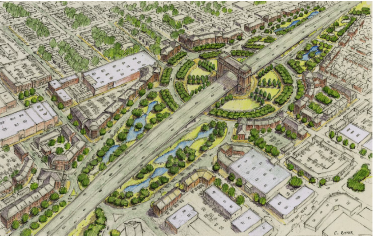
The last remaining issue to be resolved between the two alternatives is the treatment of major intersections within the “Grand Boulevard” segment of Evangeline Thruway between Mudd Avenue and Pinhook Road. The major intersections of the Thruway with Second Street/Third Street, Jefferson Boulevard, Sixth Street (which evolves into Lee Avenue upon crossing the BNSF/UP tracks), Jefferson Street/Louisiana Avenue, Twelfth Street, and Fourteenth Street/Taft Street would be allowed free flow across the boulevard in both options; the remaining cross streets would be severed and reduced to right-in/right-out termini. The difference between the two final alternatives is that one would feature signalized intersections with these major collectors/arterials as the original Thruway does (the C3 “Signalized” Alternative); while the other would convert the major intersections into roundabouts (the C4 “Roundabout” Alternative). Illustrations of the two alternatives, both their End-2-End and isolated central core sections, follow:


Many of the common features found in both finalist alternatives remain the same from the 2017 alternatives, but with some minor tweaks and revisions here and there. Going from south to north, here they are:
1) Southern Terminus to Kaliste Saloom Road Interchange
The terminus to the south on US 90 has been moved a bit further south to just before the existing Verot School Road intersection, in order to add some accessibility between the existing frontage road system along US 90, Alligator Road, and Perimeter Road. New continuous one-way access roads will be constructed to flank the existing US 90 mainline, which will be upgraded to a 6-lane fully access controlled freeway; these will also be extended southward along US 90 all the way to the Albertsons Parkway/St. Nazaire Road interchange that has been recently completed in Broussard. Interchanges/grade separations with Verot School Road, Southpark Road (LA Highway 89), and Morgan Avenue/Eola Road will also be built as part of the freeway upgrade of US 90, but that is a separate project outside of the scope of the Connector freeway. As part of the Verot School interchange, a two-way local access frontage road will be built for accessing the businesses currently along US 90; the one-way access roads will be elevated to connect to an elevated Verot School Road that will cross over both I-49/US 90 mainline and the BNSF/UP rail mainline. The two-way road will connect with the northbound one-way access road at Alligator Road, then will be extended north to curve into Perimeter Road, which serves as an access to properties on the edge of Lafayette Regional Airport. The existing continuous 2-way frontage road running on the west side of US 90 will be converted to a one-way southbound access road. Both access roads flanking the mainline of US 90 will serve as a continuation of the Evangeline Thruway and provide separate local access to the access-controlled US 90 mainline; slip ramps will provide connections between the mainline and access roads for selected interchange locations.

The Kaliste Saloom Road interchange has also been tweaked somewhat since the 2017 refinements: the original 3-level directional interchange proposed and approved in the 2003 EIS/Record of Decision process has been modified into a 2-level “diverging T” interchange, where the left turning movements between I-49 and Kaliste Saloom now connect and intersect each other at grade rather than are grade separated. In addition, the connection between Kaliste Saloom and Hugh Wallis Road has been slightly modified, with connecting roads on both sides and an additional left turn movement for westbound Kaliste Saloom traffic to access commercial properties on the east side of K-S, using the existing K-S right-of-way.
2) University Avenue/Surrey Street Overpass (Lafayette Regional Airport) to Vermilion River Crossing
The University/Surrey overpass will have a reduced vertical profile for I-49/US 90 crossing over a depressed University/Surrey, due to the need to maintain the glide path of Runway 11-29 at Lafayette Regional Airport. Originally, as part of the 2003 ROD, this was to be a conventional overpass and interchange, with the subsequent conflict with 11-29’s glide path resolved through adding a 350-foot extension and displacement to that runway. That became infeasible, however, due to LFT being mandated by the Federal Aviation Administration to construct an Engineered Materials Arresting System (EMAS) extension on the east terminus of Runway 11-29, which would use up the area where the displacement extension would have been built. A separate ROD approved by the FAA for the original runway displacement (included within the FHWA/LaDOTD 2003 ROD) will require an update to adapt to the refinements for the University/Surrey overpass for the Connector SEIS process. This also mandated that the planned interchange for University/Surrey proposed in the original 2003 FEIS/ROD would have to be moved to Pinhook Road. Access to LFT from mainline I-49 would still be possible indirectly through the Pinhook and Kaliste Saloom interchanges and the continuous one-way access road system flanking the mainline I-49/US 90 roadways.

The Connector freeway will then cross the Vermilion River using the existing Evangeline Thruway/US 90 ROW, with the existing Thruway transitioned to a 6-lane mainline freeway with 3-lane one-way access roads flanking the mainlines and providing local business access. The current pedestrian path that runs below the Thruway on the south approach of the Vermilion River that connects Beaver Lake (aka Heymann Lake) to Heymann Park and Vermilionville will remain, and will get some refinements thanks to the CSS/Joint Use enhancement addition process. In addition, a gateway will be installed as a landmark feature introducing travelers to the city of Lafayette.

3) Pinhook Road Interchange
This will serve as the southern most access point between the Connector freeway and both the McComb-Veazey and Freetown-Port Rico neighborhoods, as well as the connection to the proposed Grand Boulevard along the Evangeline Thruway, which will access downtown. The mainline freeway will pass over Pinhook Road while the one-way access roads will directly connect with Pinhook, then transition into the proposed boulevard that will be built along the ROW of the existing southbound Thruway roadway. (The existing southbound Thruway roadway will be converted back to a local two-way street and returned to the City of Lafayette for maintenance.) The mainline I-49 diverts from the existing Thruway ROW just to the north of Pinhook near the Fourteenth Street/Taft Street intersection; here is where the transition from flanking access roads to boulevard will take place. Traditional ramps will serve as the connections to and from the frontage roads and the mainline to/from the north; slip ramps will provide the same to the south. The Pinhook intersection/interchange will also feature a unique “displaced left turn” design where traffic seeking to turn south on Evangeline Thruway/I-49/US 90 from westbound Pinhook Road would have to cross over eastbound Pinhook traffic via a signalized dedicated roadway prior to approaching the Thruway intersection. This would require closing the current Pinhook Road intersection with Judy Street and transferring the latter’s connections further south to the current intersection of Pinhook with Gauthier Road. The DLT would also necessitate closure of the existing intersection of Pinhook with Chag Street; that would be reduced to a Right-In-Right-Out (RIRO) intersection.
In addition, in order to mitigate impacts to the Freetown-Port Rico neighborhood, which happens to be a designated National Historical District, access to the southbound Thruway roadway would be modified to remove direct access to homes fronting the roadway. This is because of Federally mandated access control due to the onramp from the southbound mainlane of I-49 to the Thruway for the Pinhook interchange. Drain Street, which runs parallel to the Thruway from Fourteenth Street to Sixteenth Street, will be extended further south to connect with Alley Street, thus providing an alternative frontage access to houses and properties facing the southbound Thruway. In addition, in order to allow for the transition between the boulevard section and the existing Thruway access road couplet, Fifteenth and Sixteenth streets will be severed between the access roads, and the existing northbound Thruway/future local street will be dead-ended at Fifteenth Street.

4) Central Core/Downtown Section
This is where the Connector freeway leaves the Thruway and ventures on its own new terrain alignment, keeping straight before curving north across the former property of the old Southern Pacific Railroad classification yard to shadow Chestnut Street just east of the BNSF/UP railroad line. The continuous viaduct section through here would cut through the old railyard property, cross over Johnston Street, then shade Chestnut Street between the rail line and the current southbound Thruway roadway. That ROW would be converted into the 4-lane enhanced Urban Boulevard between Fourteenth/Taft and Second Street, where the Connector viaduct would return to the Thruway ROW. The current northbound Thruway would be rebuilt as a local two-way street.
A “Signature Bridge” feature would be built on the freeway viaduct as a landmark feature for downtown Lafayette, and the entire corridor would be transformed into an enhanced urban subspace through the application of Joint Use, CSS, and Complete Streets protocols. Bicycle lanes and wider pedestrian pathways would be constructed along the Thruway boulevard, and further enhancements in lighting, greenscaping, wayfaring, and other measures would be incorporated into the freeway and boulevard to fully integrate it into the existing neighborhoods and communities. This would allow opportunities for full redevelopment of businesses that would be displaced or disrupted by the construction of the Connector, and would also allow for connectivity of the Freetown-Port Rico and McComb-Veazey neighborhoods that have been divided from each other due to the Thruway and the railroad for decades.
The only remaining feature that remains to be resolved for the project is the mode of connecting the major cross streets to the Urban Boulevard. The plan is to retain full traffic movements between the boulevard and all the major cross streets; Fourteenth/Taft, Twelfth, Johnston Street/Louisiana Avenue, Sixth (which becomes Lee Avenue after crossing the railroad), Jefferson Boulevard, and the Second Street/Third Street one-way couplet. The other streets currently crossing the Thruway/boulevard would get RIRO treatments.
Two variations are being proposed for dealing with the major intersections:
a) Signalized Alternative
In this concept, the major cross streets would use traditional signalized intersections with the boulevard. Single dedicated left turn lanes would be built at these intersections (except at Johnston/Louisiana where double lefts would be built due to the heavier traffic and major importance of that arterial). The new two-way local street made from the old northbound Thruway roadway would have stop sign controls similar to traditional local streets, but would get some enhanced treatments (including possibly bike lanes and wider sidewalks). No adjustments would be needed to the existing street grid, other than having Simcoe Street severed on the west side of the Thruway system transition area near the Sterling Grove neighborhood. That is due to the proposed off-ramp from the freeway viaduct that would serve access from the north to the boulevard and downtown (via Second Street, which would remain a one-way westbound compliment to Third Street, which would remain one-way eastbound).


b) Roundabout Alternative
For this concept, instead of conventional intersections, the main cross streets will use roundabouts to connect with the Grand Boulevard. LaDOTD has become quite enamored with replacing major intersections with roundabouts of late; they say that roundabouts are less expensive and more efficient with handling traffic than the conventional signalized intersections. CSS designers and some urban planners are also more supportive of roundabouts due to their effect of slowing down (or “calming”) traffic. The same major intersections that currently take signals on the Thruway (plus Sixth Street, which does not) which would be improved under the Signalized Alternative, would get roundabouts under this alternative; and the Johnston Street/Louisiana intersection would get a “super roundabout” with additional lanes to meet its higher capacity.
Impacts would be slightly greater with the Roundabout Alternative due to alterations required at Simcoe Street, because of the proposed “dogbone roundabout” connected to the aforementioned access ramp from the mainline Connector to Second Street. This feature would modify Second Street to allow for two-way service westbound on Second across the railroad crossing, and the dogbone roundabout would allow for access to the east side of Simcoe Street, the urban boulevard, and the revised Thruway couplet through the Sterling Grove/Martin Addition neighborhoods. However, there would be some reduced accessibility due to construction of the Third/Simcoe/Boulevard roundabout severing Chestnut Street and portions of the west side of Simcoe Street, as well as severing the former northbound roadway fronting Sterling Grove (which would also be downgraded to a two-way local street; a new one-way access road would be built parallel to and aside of the Connector elevated mainline and the southbound roadway).


5) Second Street to L&DRR Rail Spur (Sterling Grove/Ballard Addition)
The proposed Connector freeway would return to the Evangeline Thruway couplet ROW right around Simcoe Street and would remain there up to the northern terminus at the existing I-49/US 167 interchange with I-10. The mainline would remain fully elevated through the section up to past the Willow Street interchange. An off-ramp starting just above Mudd Avenue would provide local access from southbound I-49 to the urban boulevard segment of the Thruway, as well as to Second Street for downtown access. The Evangeline Thruway would remain for local access to the Sterling Grove and Ballard Addition neighborhoods flanking it, with the viaduct shading the southbound Thruway roadway. However, as with the central section, the northbound Thruway would be reconstructed on a new roadway from Second Street to near Bellot Drive, where it would meet the old northbound roadway curvature. The old, orphaned segment of the northbound Thruway would, like its other component further south, be rebuilt as a local two-way street. This is done to reduce the impact of the Thruway system on the Sterling Grove Historical District by creating more of a buffer between the Connector freeway and revised Thruway frontage road system and Sterling Grove.
Cross street access underneath the freeway between Simcoe Street and the crossing of the Louisiana & Delta Railroad (L&DRR) rail spur would be retained at Mudd Avenue (US 90 West), Sampson Street, and Bellot Drive; all other streets would be terminated at the Thruway roadways. Simcoe Street would be severed from the west due to the Second Street off-ramp in both alternatives; though both alternatives do have means of accessing the east side of Simcoe.


(Signalized Alternative)
6) L&DRR Spur to I-10/I-49 Interchange/Northern Terminus (Includes Willow Street Interchange)
From the crossing of the Louisiana & Delta Railroad spur rail line serving Breaux Bridge to Interstate 10, the proposed I-49 Connector freeway would consume the Evangeline Thruway ROW. The existing at-grade expressway features of the Thruway would be converted into a continuation of the fully elevated freeway concept north to the existing intersection of the Thruway with Castille Avenue and Martin Luther King Drive (and the local two-way frontage roads currently flanking the Thruway). A continuous one-way access road system would flank the elevated mainline to allow direct access to the mainline via the Willow Street interchange, and local access to other segments as a continuation of the Thruway. This would then transition back to an at-grade freeway north of MLK-Castille for the approach to the existing I-10 interchange.

This segment does include some major modifications to the local street system for enhancing local access and connectibility.
a) Donlon Avenue/(Former) Walmart Access Road “Dogbone Roundabout
First, a dogbone roundabount is situated just south of the crossing of the rail spur for traffic wanting to access Donlon Avenue and the former Walmart Supercenter property (currently run as a local church). This roundabout is connected to the current two-way local frontage road that serves local businesses from Donlon to Willow Street, serving to separate them from the northbound Thruway access road. This is necessary to control access for the braided ramps that will be built for access to the mainline freeway for both the Willow Street interchange and traffic leaving downtown wanting to enter the freeway. (The latter is the complement to the southbound exit at Second Street.
The existing RCUT intersection between Donlon Ave., the Thruway, and the entrance/exit to the ex-Walmart property will be removed, with Donlon terminating at the existing two-way frontage road and the Walmart egress/entrance ending in a RIRO with the southbound access road. (The existing two-way service road on the west side of the Thruway would remain as is and terminate at the Walmart access road.)

b) Willow Street Interchange
The Willow interchange will be fitted into the current ROW as a conventional slip-ramp diamond interchange, with the current Thruway roadways serving as the access connections. The frontage road connections to Willow Street will get minor tweakage in order to satisfy control-of-access requirements along Willow. The existing Lafayette Visitors Center site, now located within the median of the Thruway where it meets Willow Street, will remain in its general location, albeit adjusted to avoid being underneath the Connector viaduct structure. Access to the VC via the southbound Thruway access road would remain the same.

The MLK-Castille connection would undergo some significant changes as well. The current convoluted intersection and connection between the existing Thruway and MLK/Castille/frontage roads would be replaced with another dogbone roundabout underneath the mainline freeway, allowing for full movements between the frontage roads, Castille Avenue, and MLK Drive. There would also be connections allowing for transitions to and from the one-way access road system serving the local function of the Evangeline Thruway.
The only major revision would be the elimination of the two-way frontage road on the west side of the Thruway between MLK Drive and Willow Street. A new “boulevard” would be constructed some 400 feet west of the Thruway/Connector ROW as a new backage road connection between the two streets. The existing two-way road would be converted to a single-lane one-way connection to the southbound access road connection and off ramp from I-49 to Willow Street. Hence, those wanting to access the freeway from there on the west side would have to go over to Willow Street, or go further to the Donlon-Walmart roundabout to access the northbound on-ramp.

8) I-49/I-10 Interchange (Northern Terminus)
Finally, the Connector would feed into the existing Interstate 49 that runs north to Opelousas, Alexandria, and ultimately Shreveport, through the existing I-10/I-49 full cloverleaf interchange. Additional auxiliary lanes would be added at the northbound exit ramps to I-10 and the southbound entry ramps from I-10 in order to handle the increased flow. There are plans to convert the I-10/I-49 interchange to a fully-directional interchange in order eliminate the loop ramp movements, but that is beyond the scale and scope of the Connector project.

9) Conclusion (for now)
As of this posting (now February of 2022), that seems to be what the final proposed alternatives for the Connector freeway will encompass, though there more than likely will be some other tweaks and minor revisions as this finishes the CSS and SEIS processes. A “Supplemental Preferred Alternative” must be selected and approved by all the entities involved (LCG, LaDOTD, FHWA) before the Alternatives Analysis and full environmental impact studies can be completed; this will be presented then to the public at the next stage of public meetings that are scheduled for March or April. Then, work would be completed on the Supplemental EIS for release to the public around June or July of this year.
The SEIS would also incorporate a draft Joint Use Development Plan for any and all refinements within the direct ROW of the freeway and “grand boulevard” segments; a revised Section 106 Memorandum of Agreement for mitigation of impacts to Sterling Grove Historical District (and possibly Freetown-Port Rico Historical District as well); a CSS Design Standards Manual to incorporate and document all the CSS design features and refinements into the project; documentation of noise and air impacts and any mitigation of such as needed; and a Level 2 Environmental Assessment of the former Southern Pacific Railroad yard property for possible cleanup and mitigation of possible impacts to the Chicot Aquifer.
The completed Draft SEIS would then be subjected to feedback and analysis by all the relevant authorities, including an official Public Hearing which is tentatively scheduled for August of this year. Based on this feedback, a Final SEIS would be produced which would document the selection and approval of a final Supplemental Selected Alternative; that process would then conclude with the issuance of a Supplemental Record of Decision (S-ROD) submitting FHWA’s final approval of the project.
In short, there is still a long way to go before we can start celebrating the construction of the I-49 Lafayette Connector freeway….and that doesn’t even include the possible return of the lawsuits by those insistent on opposing this project. As always, watch this space for updates.